Hoye-Crest facts for kids
Quick facts for kids Hoye-Crest |
|
|---|---|

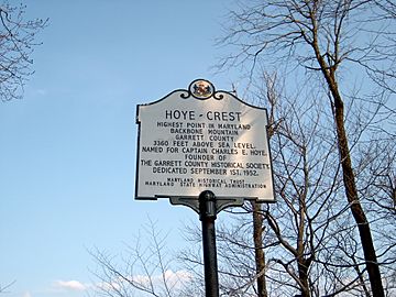
Marker at Hoye-Crest, the high point of Maryland
|
|
| Highest point | |
| Elevation | 3360+ ft (1024+ m) NGVD 29 |
| Prominence | 80 ft (24 m) |
| Parent peak | Backbone Mountain |
| Listing | U.S. state high point 32nd |
| Geography | |
| Parent range | Allegheny Mountains |
| Topo map | USGS Davis |
Hoye-Crest is a special spot in Maryland. It's the highest natural point in the state! This summit is part of Backbone Mountain. It stands tall at about 3,360 feet (1,024 meters) above sea level. You can find it in Garrett County.
This important place is named after Captain Charles E. Hoye (1876-1951). He was the person who started the Garrett County Historical Society. In September 1952, a special historical marker was placed here. This marker helps people remember Captain Hoye and the importance of this peak. From Hoye-Crest, you can see amazing views of the North Branch Potomac River valley.
Visiting Hoye-Crest
You can't drive directly to Hoye-Crest. The best way to reach this high point is by hiking. It's a fun adventure for those who love the outdoors.
The Maryland High Point Trail
The main path to Hoye-Crest is called the Maryland High Point Trail. This trail starts near U.S. Route 219. You'll find the starting point just south of Silver Lake, West Virginia. The trail follows an old logging road. This road is on land that belongs to the Monongahela National Forest.
The hike is about one mile long in each direction. It goes up Backbone Mountain until you reach the border between West Virginia and Maryland. Once you're at the state line, the trail turns north. It then leads you right to the highest point, Hoye-Crest. Even though Hoye-Crest is on private property, visitors are allowed to hike there.
 | Shirley Ann Jackson |
 | Garett Morgan |
 | J. Ernest Wilkins Jr. |
 | Elijah McCoy |


