Backbone Mountain facts for kids
Quick facts for kids Backbone Mountain |
|
|---|---|

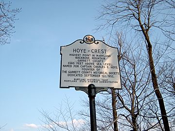
Marker at Hoye Crest, the high point of Maryland
|
|
| Highest point | |
| Peak | 3.92 mi (6.31 km) west of Thomas, West Virginia (Tucker County, West Virginia) |
| Elevation | 3,662 ft (1,116 m) |
| Dimensions | |
| Length | 39 mi (63 km) |
| Geography | |
| Country | United States |
| Parent range | Allegheny Mountains |
Backbone Mountain is a long, narrow mountain ridge. It is part of the Allegheny Mountains, which are themselves a part of the larger Appalachian Mountains in the eastern United States. This mountain sits across the states of West Virginia and Maryland. It also forms a part of the Eastern Continental Divide, which is like an invisible line that separates where water flows. In Maryland, Backbone Mountain reaches 3,360 feet or 1,024 metres high. This makes it the highest point in the entire state of Maryland!
Contents
About Backbone Mountain
Backbone Mountain stretches for about 39 miles (63 km) (63 km). It runs from the southwest to the northeast. Its starting point is near Hambleton in Tucker County, West Virginia. The mountain ends near the Savage River Reservoir in Garrett County, Maryland.
Where Water Flows: The Eastern Continental Divide
A special feature of Backbone Mountain is the Eastern Continental Divide. This divide is an imaginary line. On one side, water flows towards the Atlantic Ocean. On the other side, water flows towards the Gulf of Mexico.
In Maryland, this divide follows part of the mountain. For example, the Youghiogheny River starts northwest of the mountain. Its water eventually flows into the Mississippi River. The North Branch of the Potomac River starts just south of the mountain. Its water flows towards the Atlantic Ocean.
In West Virginia, the divide moves east. Here, both sides of Backbone Mountain drain into the Black Fork. This river then joins the Cheat River.
Crossing the Mountain
Backbone Mountain is crossed by a few important roads. U.S. Route 219 crosses the ridge twice. One crossing is north of Parsons. The other is near Silver Lake.
U.S. Route 50 also crosses the mountain. This crossing is east of Red House, Maryland. You can see a sign from the Maryland State Highway Administration there.
Cool Places to See
Backbone Mountain has some interesting spots to visit. These places offer great views and a look into the area's history.
Hoye-Crest: Maryland's Highest Point
Hoye-Crest is located on Backbone Mountain, just inside Maryland. It is the highest point in the state of Maryland. Hoye-Crest is 3,360 feet (1,020 m) (1,024 m) high.
This spot is named after Captain Charles Hoye. He was the person who started the Garrett County Historical Society. At Hoye-Crest, you can find a special marker. You can also enjoy a view of the North Branch Potomac River valley to the east. You can reach Hoye-Crest by following a path from U.S. Route 219.
Olson Observation Tower: A View from Above
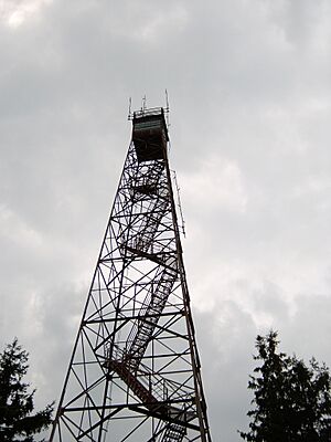
The southern end of Backbone Mountain is home to the Olson Observation Tower. This tower was West Virginia's very first fire tower. The state built the first tower in 1922. Later, it was given to the Monongahela National Forest.
In 1963, a new tower replaced the old one. It was named after Ernest B. Olson. This was to honor his 28 years of work in fire control and conservation. You can climb the 133 steps to the top of the tower. From there, you can see amazing views. These include the Cheat River watershed, Parsons, Blackwater Canyon, Canaan Mountain, and the Otter Creek Wilderness.
Crabtree Woods: An Ancient Forest
On the northwest slopes of Backbone Mountain, you'll find Crabtree Woods. This area is part of the Potomac-Garrett State Forest. It is Maryland's largest remaining old-growth forest. This means the trees here have grown naturally for a very long time.
Crabtree Woods covers over 500 acres (2.0 km2). It is filled with different kinds of Appalachian hardwood trees. You can see sugar maples, red oaks, basswood, and cucumber trees. It's a great place to see nature as it was long ago.
 | Anna J. Cooper |
 | Mary McLeod Bethune |
 | Lillie Mae Bradford |


