Tucker County, West Virginia facts for kids
Quick facts for kids
Tucker County
|
||
|---|---|---|
|
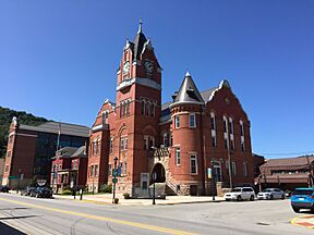
Tucker County Courthouse in Parsons
Fernow Experimental Forest
|
||
|
||
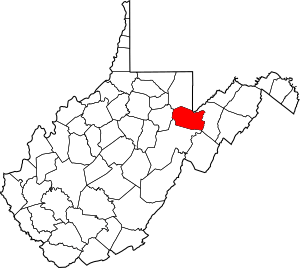
Location of Tucker County in West Virginia
|
||

West Virginia's location within the U.S.
|
||
| Country | ||
| State | ||
| Founded | March 7, 1856 | |
| Named for | Henry St. George Tucker, Sr. | |
| Seat | Parsons | |
| and largest city | ||
| Area | ||
| • Total | 1,090 km2 (421 sq mi) | |
| • Land | 1,090 km2 (419 sq mi) | |
| • Water | 5 km2 (2.1 sq mi) 0.5% | |
| Area rank | 28th | |
| Population
(2020)
|
||
| • Total | 6,762 | |
| • Estimate
(2021)
|
6,672 |
|
| • Rank | 52nd | |
| • Density | 6.201/km2 (16.062/sq mi) | |
| Time zone | UTC−5 (Eastern) | |
| • Summer (DST) | UTC−4 (EDT) | |
| Area code(s) | 304, 681 | |
| Congressional district | 2nd | |
| Senate district | 14th | |
| House of Delegates district | 85th | |
| Website | https://tuckercountycommission.com/ | |
Tucker County is a county located in the state of West Virginia, United States. In 2020, about 6,762 people lived there. This makes it one of the least populated counties in West Virginia.
The main town and government center of Tucker County is Parsons. The county was created in 1856. It was formed from a part of Randolph County, which was then part of Virginia. Later, in 1871, a small piece of Barbour County was added to Tucker County. The county is named after Henry St. George Tucker, Sr.. He was a judge and a member of Congress from Williamsburg, Virginia.
Contents
History of Tucker County
Tucker County was officially created in 1856. At that time, it was part of Virginia. In 1861, a big meeting called the Wheeling Convention took place. Because of this meeting, Tucker County and the rest of West Virginia decided to separate from Virginia. They chose to stay with the Union during the American Civil War.
How Local Government Developed
In 1863, West Virginia divided its counties into smaller areas called civil townships. The idea was to help local governments work better. But this plan was hard to follow in a state with many rural areas. So, in 1872, these townships became "magisterial districts."
Tucker County first had three townships: Black Fork, Hannahsville, and St. George. These became magisterial districts in 1872. Over the next few years, new districts were added. By the 1890s, Tucker County had seven magisterial districts.
The County Seat War
Between 1889 and 1893, there was a disagreement called the Tucker County Seat War. This "war" was between the people of Parsons and the people of St. George. They argued about where the county's main government office, or "county seat," should be located.
No one was killed during this conflict. However, it became very tense when a group of armed men from Parsons marched to St. George. They took the county's official records by force.
Forest Fires and Their Impact
Starting in 1907, the Babcock Lumber Company began cutting down many trees in Tucker County. They used a method called clear cutting, which means cutting down almost all the trees in an area. This left behind a lot of wood scraps, making the land very dry and easy to burn.
By 1910, fires were burning all the time. In some places, fires lasted for years, from spring until the first snow. This left the land with very little soil and mostly bare rock. In 1914, most of the trees were gone, and the ground burned for six months straight.
As a result, the rich topsoil that once supported huge trees washed away. This soil flowed into the narrow valleys and lowlands. These areas were already too small for farming or raising animals. The uncontrolled soil erosion and floods made the region even worse and caused many people to move away. Even today, Tucker County still shows the damage from these massive fires.
Geography of Tucker County
Tucker County covers a total area of about 421 square miles. Most of this area, about 419 square miles, is land. The remaining 2.1 square miles, or 0.5%, is water.
Main Roads in Tucker County
- U.S. Highway 219
- West Virginia Route 32
- West Virginia Route 38
- West Virginia Route 72
- West Virginia Route 90
- West Virginia Route 93
- West Virginia Route 48
Neighboring Counties
Tucker County shares its borders with several other counties:
- Preston County to the north
- Grant County to the east
- Randolph County to the south
- Barbour County to the west
State Parks and Natural Areas
Tucker County is home to beautiful state parks and important natural areas:
Federal Lands
- Canaan Valley National Wildlife Refuge
- Dolly Sods Wilderness
- Fernow Experimental Forest
- Monongahela National Forest
National Natural Landmarks
These are special natural areas recognized for their unique features:
- Big Run Bog
- Canaan Valley
- Fisher Spring Run Bog
Population and People
| Historical population | |||
|---|---|---|---|
| Census | Pop. | %± | |
| 1860 | 1,428 | — | |
| 1870 | 1,907 | 33.5% | |
| 1880 | 3,151 | 65.2% | |
| 1890 | 6,459 | 105.0% | |
| 1900 | 13,433 | 108.0% | |
| 1910 | 18,675 | 39.0% | |
| 1920 | 16,791 | −10.1% | |
| 1930 | 13,374 | −20.4% | |
| 1940 | 13,173 | −1.5% | |
| 1950 | 10,600 | −19.5% | |
| 1960 | 7,750 | −26.9% | |
| 1970 | 7,447 | −3.9% | |
| 1980 | 8,675 | 16.5% | |
| 1990 | 7,728 | −10.9% | |
| 2000 | 7,231 | −6.4% | |
| 2010 | 7,141 | −1.2% | |
| 2020 | 6,762 | −5.3% | |
| 2021 (est.) | 6,672 | −6.6% | |
| U.S. Decennial Census 1790–1960 1900–1990 1990–2000 2010–2020 |
|||
What the 2020 Census Shows
In 2020, the census counted 6,762 people living in Tucker County. There were 2,790 households. Most of the people, about 95.5%, were White. A small number were African American (0.3%), Asian (0.1%), or Native American (0.1%). About 3.7% of people were of two or more races. Hispanic or Latino people made up 0.8% of the population.
Almost half of the households (46.9%) were married couples living together. The average size of a household was 3.09 people. The average age in the county was 51 years old. About 14.9% of the people were under 18 years old. The average income for a household was $49,808. About 9.9% of the population lived below the poverty line.
What the 2010 Census Showed
The 2010 United States census found 7,141 people living in Tucker County. There were 3,057 households. The population density was about 17 people per square mile. Most people (98.7%) were white.
About 25.3% of households had children under 18 living with them. The average household size was 2.29 people. The average age was 46.3 years. The average income for a household was $32,712. About 17.7% of all people in the county lived below the poverty line. This included 20.3% of those under 18 and 20.7% of those 65 or older.
Towns and Communities
Tucker County has several towns and smaller communities.
Cities
Towns
Magisterial Districts
These are local government areas within the county:
- Black Fork
- Clover
- Davis
- Dry Fork
- Fairfax
- Licking
- St. George
Census-Designated Place
- St. George (This is a community that the census bureau tracks)
Smaller Communities (Unincorporated)
Notable People from Tucker County
- Tony Tonelli: He was a famous football player. Tony played for the USC Trojans and was a three-time letterman. In 1939, he helped his team win the Rose Bowl by blocking a punt. He was the first player from USC to be drafted into the NFL. He played one season for the Detroit Lions. Tony earned his nickname, "Two Ton" Tonelli, while growing up in Thomas, West Virginia.
See also
 In Spanish: Condado de Tucker para niños
 | James B. Knighten |
 | Azellia White |
 | Willa Brown |


