Youghiogheny River facts for kids
The Youghiogheny River, often called the Yough (pronounced "Yok"), is a cool river that flows for about 134 miles (216 km). It's like a smaller river that feeds into a bigger one, called the Monongahela River. The Yough flows through three different states in the United States: West Virginia, Maryland, and Pennsylvania.
Quick facts for kids Youghiogheny River |
|
|---|---|

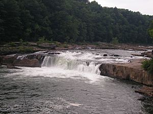
Ohiopyle Falls along the Youghiogheny
|
|

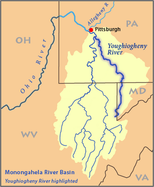
Map of the Monongahela River basin, with the Youghiogheny River highlighted.
|
|
| Country | United States |
| State | Pennsylvania, Maryland, West Virginia |
| Counties | Allegheny, PA, Westmoreland, PA, Fayette, PA, Somerset, PA, Garrett, MD, Preston, WV |
| Cities | McKeesport, PA, Connellsville, PA |
| Physical characteristics | |
| Main source | Backbone Mountain, Preston County, West Virginia 2,688 ft (819 m) 39°14′43″N 79°29′19″W / 39.24528°N 79.48861°W |
| River mouth | Monongahela River McKeesport, Allegheny County, PA 724 ft (221 m) 40°21′19″N 79°52′16″W / 40.35528°N 79.87111°W |
| Length | 132 mi (212 km) |
| Discharge (location 2) |
|
| Basin features | |
| Basin size | 1,715 sq mi (4,440 km2) |
| Tributaries |
|
| Waterbodies | Silver Lake, Youghiogheny River Lake |
Contents
Where the Yough Begins and Ends
The Youghiogheny River starts high up on Backbone Mountain in West Virginia. This is its "source," like the very beginning of its journey. From there, it flows north.
Its journey ends when it joins the Monongahela River in a town called McKeesport, in Allegheny County, Pennsylvania. This meeting point is called the "mouth" of the river.
How Long and Wide is the Yough?
The Youghiogheny River is about 132 miles (212 kilometers) long. That's a pretty long trip for a river! It drains a large area of land, about 1,715 square miles (4,442 square kilometers). This means all the rain and snow that falls in this big area eventually flows into the Yough.
The amount of water flowing in the river changes. Near Sutersville, Pennsylvania, the river usually carries about 3,477 cubic feet (98 cubic meters) of water every second. That's a lot of water moving by!
Fun Things to Do on the Yough
The Youghiogheny River is famous for its beautiful scenery and exciting activities. One of the most well-known spots is Ohiopyle Falls in Pennsylvania. It's a stunning waterfall where the river drops over rocks.
Many people love to go whitewater rafting on the Yough. The "Lower Yough" section is especially popular. It's known as one of the most active whitewater spots east of the Mississippi River. Imagine paddling through exciting rapids!
Lakes and Other Streams
Along its path, the Youghiogheny River has a big lake called Youghiogheny River Lake. This lake was created by a dam and is a great place for boating and fishing.
Many smaller streams, called tributaries, flow into the Youghiogheny River. These include the Casselman River, Indian Creek, and Jacobs Creek. They all add their water to the Yough as it flows towards the Monongahela River.
Cities Along the River
The Youghiogheny River passes through several towns and cities. Some of the main ones include McKeesport and Connellsville in Pennsylvania. These towns have grown up around the river, using its water and enjoying its beauty.
Images for kids
-
View of the Youghiogheny Valley in the Alleghany Mountains, on the Baltimore and Ohio Railroad (1898)
 | Sharif Bey |
 | Hale Woodruff |
 | Richmond Barthé |
 | Purvis Young |


