
Youghiogheny River Lake facts for kids
Quick facts for kids Youghiogheny River Lake |
|
|---|---|

The Yoghiogheny River Lake as viewed from below the Youghiogheny Dam
|
|

Youghiogheny River Lake
Location in Pennsylvania

Youghiogheny River Lake
Location in Maryland

Youghiogheny River Lake
Location in the United States
|
|
| Location | Fayette / Somerset counties, Pennsylvania, and Garrett County, Maryland |
| Coordinates | 39°47′52″N 079°22′09″W / 39.79778°N 79.36917°W |
| Type | reservoir |
| Primary inflows | Youghiogheny River |
| Primary outflows | Youghiogheny River |
| Basin countries | United States |
| Max. length | 16 miles (26 km) |
| Surface elevation | 1,440 feet (440 m) |
The Youghiogheny River Lake is a large lake in southwestern Pennsylvania and western Maryland. It was created to help control floods. This lake is a very popular spot for visitors, attracting over one million people each year.
Contents
Building the Youghiogheny Lake
The Youghiogheny River Lake was made in 1944. It was formed by building a dam across the Youghiogheny River, near a town called Confluence, Pennsylvania.
The Youghiogheny Dam
The Youghiogheny Dam is a huge structure made of earth. It stands about 184 feet (56 m) tall and stretches 1,610 feet (490 m) long at its top. The United States Army Corps of Engineers owns and takes care of the dam. This is a government group that builds and manages many water projects.
The lake's usual surface area is about 4.4 square miles (11 km2). It can hold a lot of water, up to 300,000 acre-feet (370,000,000 m3). Its normal water level is around 149,300 acre-feet (184,200,000 m3).
Why the Dam is Important
The dam helps in several ways:
- Flood Control: It stops the river from overflowing its banks during heavy rains. This protects nearby towns from floods.
- River Flow: It helps keep the river flowing smoothly, even during dry times.
- Hydroelectric Power: The dam also creates electricity. It uses the force of the water flowing through it to make 12 megawatts of clean energy.
Crossing the Lake
U.S. Route 40, a major road, goes right over the lake. It connects Jockey Hollow in Fayette County with Somerfield in Somerset County.
The Lost Town of Somerfield

Before the lake was created, there was a town called Somerfield. It was started around 1816 by Philip D. Smyth, who first called it Smythfield.
When the Youghiogheny River Lake was filled in the 1940s, Somerfield had to be moved. The town was taken apart, and the area was covered by water.
The Great Crossings Bridge
A very old stone bridge, called the Great Crossings Bridge, used to cross the Youghiogheny River at Somerfield. This bridge was part of the National Road, one of America's first major highways.
The bridge was built between 1815 and 1818 by James Kinkead, James Beck, and Evan Evans. Today, you can sometimes see parts of this old stone bridge. It becomes visible when the lake's water levels are extremely low.
Images for kids
-
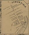
An old map of Somerfield from 1860. North is at the bottom of this map!
