
Confluence, Pennsylvania facts for kids
Quick facts for kids
Confluence, Pennsylvania
|
|
|---|---|
|
Borough
|
|
 |
|

Location of Confluence in Somerset County, Pennsylvania.
|
|

Confluence, Pennsylvania
Location in Pennsylvania
|
|
| Country | United States |
| State | Pennsylvania |
| County | Somerset |
| Settled | 1870 |
| Incorporated | 1873 |
| Government | |
| • Type | Borough Council |
| Area | |
| • Total | 1.68 sq mi (4.35 km2) |
| • Land | 1.60 sq mi (4.14 km2) |
| • Water | 0.08 sq mi (0.21 km2) |
| Population
(2020)
|
|
| • Total | 722 |
| • Density | 451.25/sq mi (174.19/km2) |
| Time zone | UTC-5 (Eastern (EST)) |
| • Summer (DST) | UTC-4 (EDT) |
| Zip code |
15424
|
| Area code(s) | 814 |
| FIPS code | 42-15680 |
Confluence is a small town, called a borough, located in Somerset County, Pennsylvania, United States. It's part of the larger Johnstown, Pennsylvania, area. The town was first settled in 1870 and officially became a borough in 1873. In 2020, about 724 people lived there.
Contents
Exploring Confluence's Location

Confluence is found at a special spot where three rivers meet. This is why it's called "Confluence"! The Casselman River and Laurel Hill Creek flow into the Youghiogheny River here. This meeting point is great for outdoor fun.
Rivers and Parks Around Confluence
The town is located at the southern end of Lower Turkeyfoot Township. Another borough, Ursina, is just to its east.
Because of the rivers, Confluence offers many chances for boating and fishing. You can also enjoy hiking nearby. Mount Davis, the highest point in Pennsylvania, is not far away.
The borough covers about 1.6 square miles (4.35 square kilometers). Most of this area is land, with a small part being water. To the south, you'll find the large Youghiogheny River Lake. To the north is the huge Ohiopyle State Park. Both offer lots of outdoor adventures.
Confluence's Weather
The weather in Confluence is generally mild. It has a climate where temperatures don't change too much between seasons. There is also a good amount of rain throughout the year.
This type of weather is known as a "marine west coast climate." Scientists use the Köppen Climate Classification system to describe it as "Cfb." This means it has warm summers and mild winters.
| Climate data for Confluence 1 SW Dam, Pennsylvania (1991–2020 normals, extremes 1946–present) | |||||||||||||
|---|---|---|---|---|---|---|---|---|---|---|---|---|---|
| Month | Jan | Feb | Mar | Apr | May | Jun | Jul | Aug | Sep | Oct | Nov | Dec | Year |
| Record high °F (°C) | 76 (24) |
78 (26) |
85 (29) |
92 (33) |
93 (34) |
98 (37) |
104 (40) |
101 (38) |
99 (37) |
91 (33) |
80 (27) |
79 (26) |
104 (40) |
| Mean daily maximum °F (°C) | 36.9 (2.7) |
40.5 (4.7) |
49.5 (9.7) |
62.7 (17.1) |
72.1 (22.3) |
79.8 (26.6) |
83.5 (28.6) |
82.2 (27.9) |
76.1 (24.5) |
64.4 (18.0) |
51.8 (11.0) |
41.2 (5.1) |
61.7 (16.5) |
| Daily mean °F (°C) | 27.9 (−2.3) |
30.3 (−0.9) |
38.1 (3.4) |
49.5 (9.7) |
59.6 (15.3) |
67.8 (19.9) |
71.6 (22.0) |
70.4 (21.3) |
63.9 (17.7) |
52.3 (11.3) |
41.0 (5.0) |
32.8 (0.4) |
50.4 (10.2) |
| Mean daily minimum °F (°C) | 18.8 (−7.3) |
20.1 (−6.6) |
26.6 (−3.0) |
36.4 (2.4) |
47.0 (8.3) |
55.7 (13.2) |
59.7 (15.4) |
58.6 (14.8) |
51.7 (10.9) |
40.1 (4.5) |
30.1 (−1.1) |
24.4 (−4.2) |
39.1 (3.9) |
| Record low °F (°C) | −30 (−34) |
−20 (−29) |
−10 (−23) |
12 (−11) |
23 (−5) |
29 (−2) |
36 (2) |
33 (1) |
23 (−5) |
16 (−9) |
4 (−16) |
−18 (−28) |
−30 (−34) |
| Average precipitation inches (mm) | 3.61 (92) |
3.41 (87) |
3.90 (99) |
4.04 (103) |
4.92 (125) |
4.86 (123) |
4.54 (115) |
4.02 (102) |
3.97 (101) |
3.35 (85) |
3.07 (78) |
3.52 (89) |
47.21 (1,199) |
| Average snowfall inches (cm) | 18.3 (46) |
16.9 (43) |
10.3 (26) |
0.9 (2.3) |
0.0 (0.0) |
0.0 (0.0) |
0.0 (0.0) |
0.0 (0.0) |
0.0 (0.0) |
0.2 (0.51) |
3.7 (9.4) |
10.9 (28) |
61.2 (155) |
| Average precipitation days (≥ 0.01 in) | 17.8 | 15.2 | 14.6 | 15.2 | 16.6 | 14.6 | 13.5 | 12.6 | 12.0 | 12.1 | 12.6 | 16.0 | 172.8 |
| Average snowy days (≥ 0.1 in) | 10.2 | 8.7 | 5.1 | 1.0 | 0.0 | 0.0 | 0.0 | 0.0 | 0.0 | 0.1 | 2.2 | 6.7 | 34.0 |
| Source: NOAA | |||||||||||||
Who Lives in Confluence?
| Historical population | |||
|---|---|---|---|
| Census | Pop. | %± | |
| 1880 | 430 | — | |
| 1890 | 444 | 3.3% | |
| 1900 | 871 | 96.2% | |
| 1910 | 890 | 2.2% | |
| 1920 | 1,031 | 15.8% | |
| 1930 | 989 | −4.1% | |
| 1940 | 1,035 | 4.7% | |
| 1950 | 1,037 | 0.2% | |
| 1960 | 938 | −9.5% | |
| 1970 | 954 | 1.7% | |
| 1980 | 968 | 1.5% | |
| 1990 | 873 | −9.8% | |
| 2000 | 834 | −4.5% | |
| 2010 | 780 | −6.5% | |
| 2020 | 724 | −7.2% | |
| 2021 (est.) | 717 | −8.1% | |
| Sources: | |||
In 2000, there were 834 people living in Confluence. These people made up 349 households. About 211 of these households were families.
Most people living in Confluence were White (99.52%). A small number were African American (0.24%) or from two or more races (0.24%).
Families and Age Groups
About 25.8% of households had children under 18 living with them. Nearly half (48.4%) were married couples. About 9.2% of households were led by a single woman.
The population was spread out by age. About 20.3% were under 18 years old. Around 23.3% were 65 years or older. The average age in Confluence was 42 years old.
Income in Confluence
In 2000, the average income for a household was $23,462 per year. For families, the average income was $31,181.
About 15.0% of families and 21.2% of all people lived below the poverty line. This included 28.7% of those under 18 and 20.4% of those 65 or older.
Images for kids
-
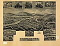
A bird's-eye view of Confluence from 1905.

See also
 In Spanish: Confluence (Pensilvania) para niños
