Ebright Azimuth facts for kids
Quick facts for kids Ebright Azimuth |
|
|---|---|

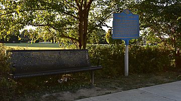
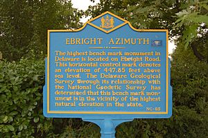
The monument sign for Ebright Azimuth, the highest point in Delaware as of September 2016
|
|
| Highest point | |
| Elevation | 448 ft (137 m) |
| Prominence | 32 ft (9.8 m) |
| Listing | U.S. state high point 49th |
| Geography | |
| Location | New Castle County, Delaware, United States |
The Ebright Azimuth is the highest point in the U.S. state of Delaware. It's not a tall mountain, but a specific spot marked with a special monument. This spot is about 448 feet (136.5 meters) above sea level.
Delaware's high point is quite low compared to other states. In fact, only Britton Hill in Florida is lower. Britton Hill is about 345 feet (105 meters) above sea level.
Contents
What is Ebright Azimuth?
Ebright Azimuth is the highest natural spot in Delaware. It has a special marker called a geodetic benchmark. This marker helps surveyors measure the Earth's surface accurately.
Where is Delaware's Highest Point?
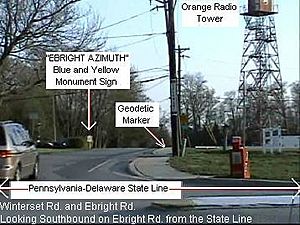
This special spot is located in northern New Castle County, Delaware. It's about 6.5 miles (10.5 kilometers) north of downtown Wilmington, Delaware. The location is very close to the border with Pennsylvania.
You can find it near Concord High School. It's also close to Naamans Road. The exact spot is at the corner of Ebright Road and Ramblewood Drive. This intersection is an entrance to a neighborhood called Dartmouth Woods.
Why is it Called Ebright Azimuth?
The name "Ebright Azimuth" comes from James and Grant Ebright. They used to own the land where the benchmark was placed.
An azimuth is a special term used in measuring. It means an angle or direction in a circular system. So, the name combines the family name with a surveying term.
The monument sign has been moved closer to the marker. The area around the sign has also been tidied up a bit.
The Old Radio Tower Story
Just south of the Ebright Azimuth marker, there's a tall radio tower. This tower was built in 1947 by a company called Western Union.
It was part of a big system that sent radio signals. This system linked New York City and Washington, D.C.. The site was called "Brandywine" after a nearby creek.
Western Union used a strong tower structure. This allowed them to put their radio equipment inside a small room at the top. Large "dish" antennas were aimed at other stations. These stations were in Mount Laurel, New Jersey and Elk Neck near Elkton, Maryland.
Over time, new technology came along. Fiber optic cables became more reliable for sending signals. Because of this, Western Union stopped using the Brandywine radio tower for its original purpose.
Today, the tower is still in use. It now holds different antennas for land mobile radio systems. These are used for things like emergency services or businesses.
 | Madam C. J. Walker |
 | Janet Emerson Bashen |
 | Annie Turnbo Malone |
 | Maggie L. Walker |


