
Hoosier Hill facts for kids
Quick facts for kids Hoosier Hill |
|
|---|---|

The "summit" of Hoosier Hill, the highest point in Indiana, June 2018.
|
|
| Highest point | |
| Elevation | 1,257 ft (383 m) |
| Prominence | 297 ft (91 m) |
| Listing | U.S. state high point 44th |
| Geography | |

Hoosier Hill
Location in Indiana
|
|
| Location | Wayne County, Indiana, United States |
| Topo map | USGS Spartanburg |
| Climbing | |
| Easiest route | Drive |
Hoosier Hill is the highest natural spot in the state of Indiana. It reaches about 1,257 feet (383 meters) above sea level. This special place is in a quiet, country area called Franklin Township in Wayne County. It's northwest of a small town called Bethel. The closest main roads are Elliot Road and County Line Road. The city of Richmond and Interstate 70 are about 11 miles (17.5 km) to the south.
Contents
About Hoosier Hill
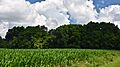
Hoosier Hill is on private land. The highest point is in a wooded area. This area is surrounded by fields used for farming.
In 2005, a young man named Kyle Cummings helped make the spot better. He was an Eagle Scout candidate. With the owner's permission, he built a path, a sign, and a picnic area. This made it easier for visitors to enjoy the highest point.
Geology of the Hill
Hoosier Hill is part of a higher land area called the Dearborn Upland. This area is in southeast Indiana. It sits on top of a large underground rock structure called the Cincinnati Arch.
However, Hoosier Hill is covered by material left behind by glaciers. This area is known as the Tipton Till Plain. Because of this, the "hill" doesn't look like a tall mountain. It's only about 30 feet (9 meters) higher than the land around it. The area looks like gently rolling farmland.
Some people might think Brown County State Park has the highest points. That park has hills that are 400 to 500 feet (120 to 150 meters) tall. But the tops of those hills are actually lower in elevation, ranging from 800 to 1,050 feet (240 to 320 meters).
First Climber
A.H. Marshall was the first person to reach the highest point in every U.S. state. He finished this big goal in 1936. Hoosier Hill was the last high point he visited to complete his journey.
The Changing Sign
For a while, a wooden sign marked "INDIANA'S HIGHEST POINT." But this sign was often stolen. So, in 2016, the local government replaced it. They put in a large rock with the words carved into it. This new sign is much harder to move or steal.
Images for kids
-
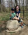
Visitors at Hoosier Hill, the highest point in Indiana
-
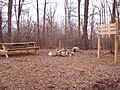
The cairn in the center marks the highpoint.
-
Hoosier Hill, Indiana. The "summit" is in the grove. June 2018


See also
 In Spanish: Hoosier Hill para niños
