
Lastarria facts for kids
Quick facts for kids Lastarria |
|
|---|---|

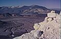
Lastarria seen from Mina La Casualidad
|
|
| Highest point | |
| Elevation | 5,706 m (18,720 ft) |
| Geography | |

Lastarria
Location in Chile
|
|
| Region, Province | Antofagasta Region Salta Province |
| Parent range | Central Andes |
| Geology | |
| Age of rock | Pleistocene-Holocene (900,000 to 2400 years BP) |
| Mountain type | Stratovolcano |
| Volcanic belt | Central Volcanic Zone |
| Last eruption | 2460 ± 50/60 years BP |
Lastarria is a tall stratovolcano that stands on the border between Chile and Argentina. It is about 5,697 metres (18,691 ft) high. This volcano is in a very remote area with no people living nearby. You can reach it by an unpaved road.
Lastarria is part of the Central Volcanic Zone. This is one of four main sections of the volcanic arc in the Andes mountains. Over 1,000 volcanoes are in this long chain, which stretches for more than 1,500 kilometres (930 mi). About 50 of these volcanoes are still active. This chain of volcanoes forms because the Nazca Plate is slowly sliding under the South American Plate.
The volcano has two main parts that form a ridge. It also has a smaller area of lava flows to the southwest. The main part of the volcano has several craters lined up in a row. There are no records of Lastarria erupting recently. However, it has strong fumarolic activity, which means it releases a lot of gas from its northern side and inside its craters.
Lastarria is built on top of older volcanic rocks. It is made of rock types called andesite and dacite. A long time ago, a large part of Lastarria's southeastern side collapsed. This caused a huge volcanic landslide. The landslide left a 1 kilometre (0.62 mi) wide scar and traveled about 8 kilometres (5.0 mi) downhill.
The strong fumarolic activity at Lastarria makes it the biggest source of volcanic gases in its region. These gases have created deposits around the vents. They have also formed flows of melted sulfur. Scientists have noticed that the ground around Lastarria is slowly rising. This might be because magma is moving deep underground.
Contents
Where is Lastarria Located?
Lastarria is in the Central Andes mountains. It is located in the Antofagasta Region of Chile. It also crosses the border into Argentina's Salta Province. The city of Antofagasta is about 250 kilometres (160 mi) northwest of the volcano.
The Central Andes are hard to get to, and their volcanoes are not watched very closely. There are no towns or cities within 150 kilometres (93 mi) of Lastarria. An unpaved road leads to Lastarria from the old Catalina railway station, which is 120 kilometres (75 mi) to the west. Unlike many other volcanoes in this area, no ancient Inka sites have been found on Lastarria. Perhaps the volcano was too active or not important to them long ago.
Lastarria is part of the Andean Central Volcanic Zone. This zone stretches over 1,500 kilometres (930 mi) from Peru to Chile. More than 1,000 volcanoes have been found here. About 50 of them are active or could become active. Many of these volcanoes are taller than 6,000 metres (20,000 ft).
How Lastarria Volcano is Built
Lastarria is made of two volcanoes that have grown together. These are the main cone and an older part called the South Spur (Espolón Sur). They join at about 5,500 metres (18,000 ft) high and form a 10-kilometre (6.2 mi) long ridge.
The main cone has lava domes, lava flows, and pyroclastic flows. It also has scoria, which are small, dark volcanic rocks. The top of the main cone is 5,697 metres (18,691 ft) high. Most of the volcano is covered by pyroclastic material. This material is made of broken rock and ash from eruptions. Some of it reaches the southeastern edge of the Salar de Aguas Calientes.
Lava flows are mostly seen on the northwestern side of the volcano. These flows can be as thick as 40 metres (130 ft). The South Spur has also produced lava flows. The entire volcano covers an area of about 156 square kilometres (60 sq mi).
There are five overlapping craters on Lastarria's main cone. They are lined up from north to south. The volcanic activity has moved north over time. The newest eruption products are found on the northern and western slopes. A lava dome sits on the rim of the northernmost crater. The South Spur has two craters of its own.
The volcano rises from ground that is about 4,200 metres (13,800 ft) high. Its slopes are quite steep. Much of the surface is covered by volcanic ash that fell from the sky. Some parts of the Southern Spur show signs of hydrothermal alteration. This means hot water and steam have changed the rocks. The total size of the volcano is about 10.1 cubic kilometres (2.4 cu mi).
The Negriales del Lastarria (also known as Big Joe) is a complex of lava flows. It is southwest of Lastarria volcano and covers a large area. It is made of several huge flows that came from one vent. The longest flow is 10 kilometres (6.2 mi) long. These are block lavas, which means they are made of rough, broken blocks of lava. This lava field is about 5.4 cubic kilometres (1.3 cu mi) in size. It is often grouped with Lastarria and the South Spur as the Lastarria Volcanic Complex.
Nearby mountains include Chili volcano to the northeast. To the northwest is the 4,709-metre (15,449 ft) high Cerro Bayo. The 5,214-metre (17,106 ft) high Cerro Piramide is near Negriales de Lastarria in the southwest. Almost directly north of Lastarria is the Laguna de la Azufrera. This is a salt pan with water that is almost a lake. Its name refers to the sulfur deposits from Lastarria. The gases from the volcano might flow into this water, leaving sulfur on the southern shore. The lake used to be bigger in the past.
The Huge Landslide Scar
A very large sector collapse happened on Lastarria's southeastern side. This left a clear scarp (a steep slope or cliff) on the volcano. It opens towards the east-southeast. The scarp is up to 120 metres (390 ft) high and forms a half-circle almost 1 kilometre (0.62 mi) wide.
The debris avalanche deposit is 8 kilometres (5.0 mi) long. It is well-preserved with features like lobes, levees, and hummocks. After leaving the collapse scar, it flowed over an older scoria cone before stopping. The slide formed 500-metre (1,600 ft) wide and 40-metre (130 ft) high lobes. These were bordered by levee-like structures up to 20 metres (66 ft) high. Unlike many debris avalanches, Lastarria's avalanche does not have many large blocks. It also has only a few hummocks.
The avalanche moved very fast. It was estimated to be over 84 metres per second (280 ft/s), or even 58–75 metres per second (208–270 km/h). It's possible that air got mixed into the debris. This would have made it act like an ignimbrite, which is a fast-moving cloud of hot gas and volcanic debris. The collapse happened without any warning signs of the volcano becoming unstable.
The avalanche deposit is mostly made of loose material like ash, lapilli (small volcanic rocks), and pumice. It has only a few lithic blocks (pieces of older rock). This loose material might explain why there are no huge blocks. The total volume of the landslide is about 0.091 cubic kilometres (0.022 cu mi). This is less than the landslides from Mount St. Helens or Socompa. It is similar to the landslide caused by the 1970 Ancash earthquake on Huascarán in Peru in 1970. That event killed over 20,000 people. There is also evidence that Lastarria has had other collapses before and that its sides are still unstable.
How Lastarria Formed
Off the western coast of South America, the Nazca Plate is sliding under the South America Plate. This happens at a speed of 7–9 centimetres per year (2.8–3.5 in/year). This process is called subduction. Volcanoes in the Andes form in four different areas. Lastarria is in the Central Volcanic Zone.
The first volcanic activity on the west coast of South America happened a very long time ago, during the Jurassic period. This was when the South Atlantic Ocean started to open. Later, during the late Cenozoic era, a chain of volcanoes formed. These volcanoes were built on top of older rocks. This volcanism began about 25 million years ago. The rocks are mostly acidic rocks.
Lastarria and Cordón del Azufre are a group of volcanoes on the Altiplano. This is a high plateau on the border between Chile and Argentina. These volcanoes were active during the Quaternary period. The Bayo volcano is sometimes considered part of this group too.
Lastarria is built on a base of older volcanic rocks. These rocks are from the Miocene to Pleistocene ages. Below them are even older rocks from the Paleozoic era. A major crack in the Earth's crust, called the Archibarca lineament, crosses the main volcanic chain at Lastarria. Other volcanoes and ore deposits are also found along this line. This crack might be a weak spot that helps magma rise to the surface.
Climate and Plants
Lastarria has a montane climate. This means it is very dry because it is where the summer rain region of the Altiplano meets the Atacama Desert. Temperatures as low as −24 °C (−11 °F) have been recorded. It gets only 20–50 millimetres per year (0.79–1.97 in/year) of rain. Some low bush vegetation grows in the area.
Lastarria's Eruptive History
The South Spur part of Lastarria is the oldest structure. The Negriales lava field formed later. The five craters of Lastarria itself formed in five different stages. Some scientists think Negriales formed even before the South Spur. They also believe the main volcano formed in ten different stages.
Lastarria's activity has included block-and-ash flows, hot avalanches, lava domes, and lava flows. Most of the deposits on the northern slopes came from the last two stages of eruptions. Overall, the more recent activity at Lastarria, especially during the Holocene period, was very explosive. This is different from the earlier eruptions, like the Negriales ones, which were more gentle lava flows.
Scientists have used dating methods to find the ages of Lastarria's rocks. The Negriales lava field is about 400,000 to 116,000 years old. The South Spur is about 150,000 years old. The main part of the volcano started forming about 260,000 years ago. One lava flow is about 51,000 years old. Then, there was a quiet period until the Holocene era.
Three ignimbrites erupted during the Holocene, between 4,850 and 2,460 years ago. These were deposited around the volcano, especially to the north and west. Most of the volcano formed after the last glacial period. The Holocene explosive eruptions happened about every 1,660 to 2,390 years. The large landslide also happened during the Holocene, about 7,430 years ago. The lava dome on the northernmost crater rim is the youngest part of Lastarria. The youngest dated deposit is 2,460 years old, but there might be an even younger pyroclastic flow.
No eruptions have been recorded in history. However, earthquakes have been felt at the volcano. Hot spots can be seen from satellite images, which are linked to the areas where gases are released. Temperatures at these hot spots are around 6 °C (279 K). People realized Lastarria could be a source of geothermal power as early as 1974. It is considered Argentina's 9th most dangerous volcano out of 38.
Fumarolic Activity: Volcano's Breath

Lastarria shows strong fumarolic activity on its summit and down its northwestern slopes. This activity has been seen since Europeans first discovered Lastarria in the late 1800s. Lastarria is the only volcano in this area that still has active fumaroles.
Fumaroles are like small chimneys, cones, or cracks that release gases. They can be 15-centimetre (5.9 in) high chimneys or small cones up to 2 metres (6 ft 7 in) tall. Some are 2.5 metres (8 ft 2 in) wide craters or 100 by 50 centimetres (39 by 20 in) fractures. Gases also escape through cracks in the ground. Individual fumaroles are found in the craters, on their edges, and on the slopes. A crack running northwest–southeast is linked to some of these fumaroles.
Four different areas of fumaroles have been found. One is along this crack on the northwestern slope, between 4,950 to 5,140 metres (16,240 to 16,860 ft) high. Two others are on the rims of the fourth crater. One is in the fifth crater. The crack area is the largest, covering about 0.023 square kilometres (0.0089 sq mi). The other areas can be as small as 0.001 square kilometres (0.00039 sq mi). The way the fumaroles are lined up suggests that the volcano's structure controls where they appear. There is evidence that the gases from the fumaroles have changed over time. This suggests more influence from magma between 2009 and 2012.
The gases from the fumaroles have temperatures from 80 to 408 °C (176 to 766 °F). Carbon dioxide is the main gas besides water vapor. Other gases include hydrogen, hydrogen chloride, hydrogen fluoride, hydrogen sulfide, nitrogen, and sulfur dioxide. The gases also contain small amounts of alkanes, alkenes, argon, carbon monoxide, helium, methane, and oxygen. The makeup of these gases shows that most of them come from deep inside the Earth (magma). Very little comes from the atmosphere. Also, most of the water comes from the magma, not from rain. This is because the area is very dry.
In 2012, scientists studied five volcanoes. Lastarria had the highest rates of gas flow. Here's a table showing some of the gases released:
| Volcano | Carbon dioxide | Hydrogen bromide | Hydrogen chloride | Hydrogen fluoride | Hydrogen sulfide | Sulfur dioxide | Water |
|---|---|---|---|---|---|---|---|
| Lascar | 534 | 0.15 | 199 | 9.4 | 30 | 554 | 5,192 |
| Lastarria | 973 | 0.6 | 385 | 5.8 | 174 | 884 | 11,059 |
| Ollague | 150 | ||||||
| Putana | 68.5 | ||||||
| San Pedro | 161 |
The gases from Lastarria have changed over time. The amount of magmatic gas increased between 2009 and 2012. This could be due to different ways of measuring or actual changes in the volcano's activity. Temperatures have been seen to drop after rainfall.
The gases come from a hot underground system. This system is fed by magma located 7 to 15 kilometres (4.3 to 9.3 mi) deep. As the gases rise, they interact with the surrounding rocks and underground water.
Arsenic is a harmful substance found in high amounts in waters of northern Chile. Gases from Lastarria can contain over 1 gram per kilogram (0.016 oz/lb) of arsenic in the sediments. The volcano is a major source of arsenic in the southern Central Volcanic Zone.
Sulfur Flows at Lastarria
The fumaroles on Lastarria have created large deposits of bright yellow sulfur. This sulfur has also formed flows, like slow-moving rivers of melted sulfur. The two largest flows are 350 metres (1,150 ft) and 250 metres (820 ft) long. The longer flow is partly covered by the shorter one.
Scientists haven't found clear vents where the sulfur flows out. It seems to come from the ground in the fumarole areas. One andesite lava flow has several smaller sulfur flows. These look like pahoehoe flows, which are smooth, ropy lava flows. They are 1 to 2.5 metres (3 ft 3 in to 8 ft 2 in) wide. It is likely that sulfur deposited by the fumaroles melted and formed these flows. Some fumaroles are currently releasing sulfur flows that are a few centimeters long. Sulfur flows are very delicate and can be easily destroyed.
The conditions when the sulfur formed caused it to have many different colors. These include black, brown-orange, orange, red, yellow, and yellow-orange. The colors change along the length of the flows and between different flows. This shows that temperatures varied. Liquid sulfur has different thickness and flow properties at different temperatures.
Sulfur flows like these are rare on Earth. They might be more common on Jupiter's moon Io. On Earth, they have been found at places like Kawah Ijen in Indonesia and Mount Iō (Shiretoko) in Japan. They have also been seen at Mauna Loa in Hawaii, Momotombo in Nicaragua, and Sierra Negra on the Galapagos Islands. The sulfur flows on Lastarria might be at risk from future mining in the area.
Ground Uplift: Rising Earth
Scientists have used satellite images to study the ground around Lastarria. Between 1998 and 2000, they found that the ground was rising. This uplift is centered between Lastarria and Cordón del Azufre. It is known as "Lazufre" and covers an area of 45 by 37 kilometres (28 by 23 mi).
This uplift seems to be caused by magma being injected deep underground. The amount of magma increased between 2003 and 2006. The source of this uplift is thought to be at depths of 9 to 17 kilometres (5.6 to 10.6 mi), or later calculated as 2 to 14 kilometres (1.2 to 8.7 mi). This rising of the ground might have been happening for about 400,000 years. It has even affected where lava flows from Lastarria and other volcanoes ended up.
Ground uplift has also been detected at Lastarria itself. It is rising about 9 millimetres per year (0.35 in/year). This rising area is smaller than Lazufre, about 6 square kilometres (2.3 sq mi) or 6 kilometres (3.7 mi) wide. The uplift at Lastarria started later than the Lazufre uplift and might be affected by it. It's possible that magma entering the Lazufre magma chamber is affecting Lastarria's hydrothermal system. This could explain the changes in gas output from the fumaroles observed between 2006 and 2012. Models suggest the source of this uplift is about 1,000 metres (3,300 ft) deep and shaped like a sphere. Another estimate puts the source inside the volcano itself, about 230 to 360 metres (750 to 1,180 ft) in size. Its volume is increasing by about 8,000 to 18,000 cubic metres per year (280,000 to 640,000 cu ft/a) each year.
The ground is still rising, but it slowed down between 2006 and 2016. At other volcanoes, this kind of uplift has been linked to changes in fumarole activity or even the start of an eruption.
What are the Dangers?
Lastarria volcano is in a remote area. This means it poses little risk to human settlements. The closest small communities are at Mina Vaquillas, Mina El Guanaco, and Campamento Pajonales.
The Chilean SERNAGEOMIN (a government agency for geology and mining) has a volcano alert rating for Lastarria. A permanent seismometer (a device to detect earthquakes) was installed on the volcano in late 2013. Lastarria is considered the 45th most dangerous volcano in Chile.
Images for kids
-
Lastarria seen from Mina La Casualidad
See also
 In Spanish: Volcán Lastarria para niños
- Cerro Escorial
- Corrida de Cori
- List of volcanoes in Chile
- List of volcanoes in Argentina
