
Socompa facts for kids
Quick facts for kids Socompa |
|
|---|---|

Socompa as seen from near the Salar de Imilac.
|
|
| Highest point | |
| Elevation | 6,051 m (19,852 ft) |
| Prominence | 2,015 m (6,611 ft) |
| Parent peak | Ojos del Salado |
| Listing | Ultra, |
| Geography | |

Socompa
Location in Argentina
|
|
| Location | Argentina – Chile |
| Parent range | Andes |
| Geology | |
| Mountain type | Stratovolcano |
| Last eruption | 5250 BCE (?) |
| Climbing | |
| First ascent | 1908 - Friedrich Reichert (Germany) |
| Easiest route | glacier/snow |
Socompa is a huge stratovolcano located right on the border between Argentina and Chile. It stands very tall, reaching 6,051 metres (about 19,852 feet) into the sky. This volcano is part of the Andean Volcanic Belt, which is a long chain of volcanoes in the Andes mountains. This chain starts in Peru and goes through Bolivia, Chile, and Argentina. It has about 44 active volcanoes! Socompa is also near a pass (a low point in the mountains) that shares its name. A railway line, the Salta-Antofagasta railway, crosses the border here.
Socompa is famous for a massive debris avalanche that happened 7,200 years ago. A huge part of its side collapsed and slid down, creating a vast area of rock and debris. Scientists first thought it was a different type of deposit. But after the 1980 eruption of Mount St. Helens (another volcano that had a big collapse), they realized Socompa's feature was also a giant landslide. This collapse is one of the biggest ever known, with a volume of 19.2 cubic kilometres (about 4.6 cubic miles). It covers an area of 490 square kilometres (about 189 square miles). The dry climate has kept its features very well preserved. After this huge landslide, the volcano slowly rebuilt itself with new lava flows, filling in much of the scar.
Socompa is also special because of the unique living things found high up on its slopes. These high-altitude communities live near fumaroles (vents that release gas from the volcano). They grow much higher than other plants in the area. The climate on the mountain is very cold and dry.
Contents
Exploring Socompa's Location and Shape
Socompa sits right on the border between Argentina and Chile, to the east of a place called Monturaqui. The Salta–Antofagasta railway crosses the border just below Socompa. This makes the volcano quite easy to reach, even though it's in a remote area. This same pass was an important route between the two countries for a long time.
Local people consider Socompa an apu, which means a sacred mountain. There are even reports of ancient Inca buildings on its slopes or at its top. The name "Socompa" comes from the Kunza language. It might mean "spring" or "arm of water."
Socompa's Place in the Andes
Socompa is part of the Central Volcanic Zone. This is one of four main volcanic areas in the Andean Volcanic Belt. This zone stretches across Peru, Bolivia, Chile, and Argentina. It has about 44 active volcanoes. Many older, inactive volcanoes are also found here. They are well preserved because the region is very dry. Most of these volcanoes are in faraway places, so they haven't been studied much. They also don't pose a big threat to people. The largest eruption in this zone happened in 1600 in Peru at Huaynaputina. The most active volcano recently has been Lascar in Chile.
What Does Socompa Look Like?
Socompa is a 6,051-metre (19,852 ft) tall composite volcano. It has a main cone and several lava domes. It's one of the largest cone-shaped volcanoes in the Central Volcanic Zone. It rises more than 2 kilometres (1.2 miles) above the land around it.
The top part of the volcano is made of several dacitic lava flows. The newest one comes from a dome at the very top. This summit dome has a summit crater (a bowl-shaped opening) at 5,850 metres (19,193 ft) high. There are four more craters to the northeast of the summit. To the northwest, a lava dome has created a 500-metre (1,640 ft) high slope of loose rocks.
The summit area is surrounded by a steep cliff that opens to the northwest. A large, wedge-shaped scar is visible on the northwestern side. This scar was left by the huge collapse. Some reports even mention a lake inside this scar at 5,300 metres (17,388 ft) elevation.
You can see a pumice deposit on the northeastern side of the volcano. Lava domes are found on the southern and western slopes. Lava flows are mostly on the eastern and northern slopes. The whole volcano is about 16 kilometres (10 miles) wide. It probably started as a mix of lava domes, lava flows, and other volcanic materials.
Socompa volcano sits in a valley that runs northwest. The southern part of this valley now holds Laguna Socompa, a lake at 3,400 metres (11,155 ft) elevation.
The Giant Landslide: Socompa's Sector Collapse
Socompa experienced a huge sector collapse during the Holocene period. This created one of the largest landslide deposits on land. Scientists first saw this deposit in 1978 in aerial photography. But they didn't realize it was a landslide until 1985. At first, they thought it was a different type of rock formation.
The collapse removed about 70 degrees of Socompa's side on its northwestern part. This huge amount of material fell about 3,000 metres (9,843 ft) vertically. It then spread out over 40 kilometres (25 miles) away from the volcano. It moved very fast, around 100 metres per second (224 miles per hour)! As it slid, the landslide gained so much energy that it could even climb over hills, rising about 250 metres (820 ft).
The total amount of material that collapsed was about 19.2 cubic kilometres (4.6 cubic miles). This material expanded as it flowed, ending up as a deposit of 25.7 cubic kilometres (6.2 cubic miles). The landslide mixed everything together as it moved. The top of the volcano was cut by this collapse. Before the collapse, the volcano was about 6,300 metres (20,669 ft) high.
The collapse left a triangle-shaped scar. This scar was partly filled by large blocks left behind. The walls of this scar were about 2,000 metres (6,562 ft) high! After the main collapse, new lava flows and pyroclastic flows (fast-moving currents of hot gas and volcanic debris) filled up the scar.
A similar collapse happened during the 1980 eruption of Mount St. Helens. In fact, that event helped scientists understand what had happened at Socompa. Other volcanoes like Aucanquilcha and Llullaillaco have also had large collapses. For Socompa, the collapse might have been caused by the ground beneath it tilting to the northwest. This made the volcano unstable in that direction.
The collapse happened about 6,180 years ago. It probably only lasted about 12 minutes! After the collapse, the volcano started growing faster. This might be because removing so much weight from the volcano helped the magma system below.
Some evidence suggests that a lava flow was erupting when the landslide happened. This, along with volcanic ash found nearby, means that volcanic activity might have started the collapse. Another idea is that the volcano became unstable because of weak layers of rock deep underground. These layers could have deformed and spread out, causing the volcano to slide.
The collapse released a huge amount of energy. Some signs suggest a powerful blast happened with the collapse. These types of collapses are very dangerous. The debris avalanches can travel very far from the volcano. The way the rocks broke apart into fine material during the landslide might have made it flow even more easily.
What the Landslide Left Behind
.jpg)
The landslide deposit covers an area of 490 square kilometres (189 square miles). It forms a surface called "Negros de Aras" to the northwest of the volcano. It also forms the "El Cenizal" surface to the north. The name "Negros de Aras" was given before people knew it was a landslide.
The thickness of the deposit changes. It's less than 10 metres (33 ft) thick in some parts and up to 90 metres (295 ft) thick in the middle. The deposit spreads out to a maximum width of 20 kilometres (12 miles). It has raised edges, called levees, that are over 40 metres (131 ft) high.
The landslide deposit contains very large blocks of rock called toreva blocks. These blocks were torn from the mountain and stopped without much change. They form ridges up to several hundred metres high. The biggest blocks are 2.5 kilometres (1.6 miles) long and 1 kilometre (0.6 miles) wide. They make up about 11 cubic kilometres (2.6 cubic miles) of the total volume. These blocks form a nearly closed semicircle at the opening of the collapse scar.
Besides these huge blocks, there are also smaller blocks up to 25 metres (82 ft) in size. These form large fields of boulders. The surface of the landslide also has hummock-like hills and small dips. Part of the landslide deposit was later covered by pyroclastic flows. This covered area is known as the Campo Amarillo.
The dry climate has kept this landslide deposit very well preserved. It's one of the best-preserved deposits of its kind in the world. However, because it's so big, scientists only fully understood its structure with the help of remote sensing (like satellite images).
Socompa's Rocks and Minerals

How Volcanoes Form Here
Volcanoes in the Central Volcanic Zone of the Andes form because the Nazca Plate is sliding underneath the South America Plate. This process is called subduction. It happens in the Peru-Chile Trench at a speed of 7-9 centimetres (2.8-3.5 inches) per year. This sliding motion melts rock deep underground, creating magma that rises to form volcanoes.
What Socompa is Made Of
Socompa has erupted two main types of volcanic rock: andesite and dacite. Dacite is the more common type. When you look at the rocks from the landslide, you can find small crystals (called phenocrysts) of minerals like augite, hornblende, and plagioclase. Dacite rocks also contain biotite, while andesite rocks have olivine. At the very top of the volcano, the rocks have been changed by hot water and gases. You can find clay, silt, and sulfur in these rocks.
Climate and Life on Socompa
The climate at Socompa is very windy and dry. The volcano is in a desert area called the Desert Puna. It often has snow cover and tall snow formations called penitentes, but no true glaciers. Because there are few clouds, the sun shines very strongly.
In 1991, weather data showed an average temperature of -5.5 degrees Celsius (22.1 degrees Fahrenheit). There were also big changes in temperature between day and night. Today, the area gets about 400 millimetres (16 inches) of rain per year, though some estimates are even lower.
Amazing Life at High Altitudes
Socompa is home to amazing plant and animal communities that live at very high altitudes. These communities are found near fumaroles (gas vents) and warm spots on the mountain, between 5,750 and 6,050 metres (18,865 and 19,849 ft) high. These are the highest known plant communities in the world! They grow both on the active fumaroles and on "cold fumaroles" (places where gases are released but without much heat).
The plants and animals here are often extremophiles. This means they are special organisms that can live in very harsh environments. The communities also include heterotrophic species, which get their food from other organisms. These include types of fungi like ascomycota and basidiomycota. The basidiomycota here are similar to those found in Antarctic regions.
The fumaroles on Socompa also have patches of bryophytes (like liverworts and mosses), as well as lichens and algae. Even small animals have been found living in these patches. These plant patches are among the highest in the world and cover surprisingly large areas despite the extreme elevation. They are quite far from other plant life in the region. The plants here are very different from the surrounding desert plants. Instead, they look more like plants found in wet, high-altitude grasslands (like the paramo) and cloud forests in South America.
Some sparse plants also grow on the lower slopes of Socompa. Animals like the black-headed lizard and Liolaemus porosus live on its slopes. Mice have even been seen near the summit!
Socompa's Eruptive Past
Socompa's volcanic activity began with the eruption of andesite rocks. Later, it started erupting dacite. Several powerful, explosive eruptions (called Plinian eruptions) have happened at Socompa. Scientists have used different methods to figure out the ages of Socompa's rocks. Some parts of the volcano are millions of years old, while others are much younger. For example, some lava flows on the southern side are between 22,100 and 69,200 years old.
After the huge sector collapse 7,200 years ago, the volcano kept erupting. These new eruptions helped fill in the big scar left by the collapse. The explosion craters at the summit are the youngest features on Socompa. One dome inside the scar is about 5,910 years old. The youngest eruption happened about 5,250 years ago.
Socompa looks like a young volcano, similar to other active volcanoes in the Andes. This suggests it has been active recently.
Is Socompa Still Active?
There are no records of Socompa erupting in recent human history. It is not considered an active volcano right now. However, scientists have seen fumarolic activity (gas coming out of vents) and the release of carbon dioxide (CO2). This fumarolic activity is relatively weak and happens at several spots. People have also reported a smell of sulfur at the summit.
Socompa is ranked as Argentina's 13th most dangerous volcano out of 38. There isn't much nearby that a future eruption could harm, mostly just the Socompa railway station and some mining camps. If a large explosive eruption happened in summer, ash and debris would likely fall to the west of the volcano. In other seasons, it would mostly fall to the east.
The groundwater (water underground) near Socompa is warmer and has more CO2. This suggests that volcanic gases are still coming out of the volcano. It also shows that the volcano affects the underground water systems. There are also hot springs at Laguna Socompa. In 2011, a mining company thought about building a geothermal power plant on Socompa to create energy. In 2018, an Argentine agency started exploring for geothermal power here.
Images for kids
-
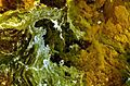
El Negrillar volcano just north of Socompa. The white area to the right is part of the Socompa landslide deposit.
-
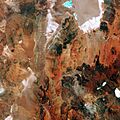
A space image of the region northwest of Socompa. The volcano is in the lower right corner.


See also
 In Spanish: Volcán Socompa para niños
- List of volcanoes in Argentina
- List of volcanoes in Chile
- List of Ultras of South America
