
Aucanquilcha facts for kids
Quick facts for kids Aucanquilcha |
|
|---|---|

View of Aucanquilcha volcano from the northwest
|
|
| Highest point | |
| Elevation | 6,176 m (20,262 ft) |
| Prominence | 2,145 m (7,037 ft) |
| Parent peak | Huascaran |
| Naming | |
| Etymology | Quechua: Auqa/aukka; "cruel"/"enemy", kichka/khiska; "spine"; "cruel spine" |
| Pronunciation | OW-kahn-KEEL-chuh |
| Geography | |

Aucanquilcha
Location in Chile
|
|
| Parent range | Andes |
| Geology | |
| Age of rock | Up to 11 Ma (Late Miocene) |
| Mountain type | Stratovolcano |
| Type of rock | Dacite |
| Volcanic arc/belt | Central Volcanic Zone |
| Last eruption | 240,000 ± 50,000 years ago (Pleistocene) |
Aucanquilcha is a huge stratovolcano in northern Chile. It's located in the Antofagasta Region, close to the border with Bolivia. This volcano is part of the Andes mountains and the Central Volcanic Zone.
Aucanquilcha looks like a long ridge and stands tall at 6,176 metres (20,262 ft) (about 20,262 feet). It's part of a bigger group of volcanoes called the Aucanquilcha cluster. This whole cluster formed over 11 million years! During the ice ages, glaciers covered Aucanquilcha and the other volcanoes, shaping them with moraines (rock piles left by glaciers) and cirques (bowl-shaped hollows).
Today, Aucanquilcha still has some fumarolic activity, which means it releases steam and gases. You can also find sulfur deposits near the top. For many years, there were sulfur mines on the volcano. One mine, at 5,950 metres (19,520 ft) (about 19,521 feet), was the highest in the world. It operated from 1950 to 1992. People even lived permanently at these high altitudes, making them the highest residents on Earth!
Contents
Exploring Aucanquilcha
Where is Aucanquilcha?
Aucanquilcha is a key part of the Central Volcanic Zone (CVZ) in the Andes. This area in South America is known for its many volcanoes. The CVZ has been active for millions of years, creating huge amounts of volcanic rock.
The Aucanquilcha volcano sits on an older platform of rock. It rises more than 1,400 metres (4,600 ft) (about 4,593 feet) above this base. The main volcano is a long chain of stratovolcanoes, stretching about 8 kilometres (5.0 mi) (5 miles) from east to west. It's estimated to contain 37 cubic kilometres (8.9 cu mi) (about 9 cubic miles) of volcanic material.
The wider Aucanquilcha cluster includes about 19 to 20 volcanoes. Over 11 million years, these volcanoes have produced a massive 340 cubic kilometres (82 cu mi) (about 81 cubic miles) of rock. This huge area, covering 700 square kilometres (270 sq mi) (about 270 square miles), is surrounded by salt flats and alluvial deposits (sediment left by rivers).
How the Volcano Formed
The Aucanquilcha cluster formed in four main stages, each creating a group of volcanoes.
Early Volcanoes: Alconcha Group
The first group, called the Alconcha group, formed between 11 and 8 million years ago. It includes seven volcanoes made of different types of lava. Two of the oldest are Alconcha and Volcan Tuco. These volcanoes are now heavily worn down by time.
Middle Volcanoes: Gordo and Polan Groups
After a break, the Gordo group erupted between 6 and 4 million years ago. These volcanoes are found in the southern and western parts of the cluster. Cerro Gordo, for example, has a crater with cracks that show its inner layers.
The Polan group, active from 3.6 to 2.3 million years ago, is the largest group. It includes ten volcanoes spread out, like Miño Volcano and Cerro Tres Monos. The Aucanquilcha platform, which is the base under the main Aucanquilcha volcano, also formed during this time.
The Main Aucanquilcha Volcano
The main Aucanquilcha volcano itself formed in four stages, starting about 1 million years ago.
- Azufrera Stage: This was the biggest stage, forming most of the volcano between 1.04 and 0.92 million years ago. Lava flows from this time were thick and blocky.
- Rodado Stage: This stage happened from 0.95 to 0.85 million years ago, building up the eastern slopes. The lavas were also blocky but often thicker. During this time, a large part of the volcano might have collapsed, possibly due to an earthquake.
- Cumbre Negra Stage: This stage, likely around 0.6 to 0.5 million years ago, created the westernmost peak. It's known for a pyroclastic flow (a fast-moving mix of hot gas and volcanic rock) that happened when a lava dome collapsed.
- Angulo Stage: The youngest stage, from 0.66 to 0.24 million years ago, created the highest part of Aucanquilcha. Lava flows from this stage are less weathered and sometimes cover older glacial deposits.
Even though there's no sign of recent eruptions, Aucanquilcha still has active fumaroles. These are vents that release steam and gases, showing the volcano is still alive deep down.
Glaciers and Water
Today, Aucanquilcha doesn't have glaciers, even though it's very tall. This is because the climate in the area is very dry.
However, in the past, during the Quaternary period, the volcano was covered by glaciers. You can still see signs of these glaciers, like glacial striations (scratches on rocks) and moraines, especially above 4,500 metres (14,800 ft) (about 14,764 feet). Geologists have found evidence of at least two different periods when glaciers covered the volcano.
Water from Aucanquilcha feeds some of the springs that form the Rio Loa. This river drains the western and northwestern sides of the volcano. The eastern side drains into salt flats like the Salar de Ollagüe. Most of the valleys around the volcano only have water flowing through them sometimes, or not at all, because of the dry climate.
People and Mining on the Mountain


Aucanquilcha is famous for its sulfur mines. A well-known mine at 5,950 metres (19,520 ft) (about 19,521 feet) was opened in 1913. This mine produced sulfur that was 30% pure!
At first, llamas were used to carry the sulfur down the mountain. Later, an aerial cableway (like a ski lift for cargo) was built to transport the sulfur to the town of Amincha. From there, trucks took it to other places to be processed or shipped. The mine was very active from 1950 to 1992. The cableway ruins can still be seen today.
The road leading up to the mine was built in 1972, but it's now blocked by rock falls. There are still old roads and ruins of mining stations high up on the mountain.
Living at High Altitudes
The sulfur mine on Aucanquilcha was not only the highest mine in the world but also the highest place where people lived permanently.
In 1986, it was reported that a few men, who were caretakers of the mine, lived in a metal hut at an altitude of 5,900 metres (19,500 ft) (about 5,944 meters). One of them had reportedly lived there for two years! These people are considered the highest human inhabitants on Earth.
Studies on the Aymara miners from Aucanquilcha showed that they were very well-adapted to the high altitude. They had special ways their bodies worked that helped them breathe and live comfortably in such thin air.
Images for kids
-
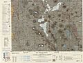
This map shows Aucanquilcha (white area in the upper left) near the Chile-Bolivia border.
-
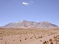
A view of Aucanquilcha volcano.
-
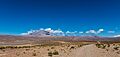
A landscape view of the Aucanquilcha area.


See Also
 In Spanish: Volcán Aucanquilcha para niños
- List of volcanoes in Chile
