
Loa River facts for kids
Quick facts for kids Loa |
|
| River | |
 Loa river in Calama
|
|
| Country | Chile |
|---|---|
| Regions | Antofagasta, Tarapacá |
| Provinces | El Loa, Tocopilla, Tamarugal, Iquique |
| Comunas | Ollagüe, Calama, María Elena, Tocopilla, Pica, Pozo Almonte, Iquique |
| Tributaries | |
| - left | San Pedro de Inacaliri, Salado |
| - right | San Salvador |
| City | Calama |
| Source | near the Miño volcano |
| - location | El Loa, Antofagasta, Chile |
| - elevation | 4,277 m (14,032 ft) |
| - coordinates | 21°04′09″S 68°30′27″W / 21.06917°S 68.50750°W |
| Mouth | Pacific Ocean |
| - location | Tamarugal, Tarapacá, Chile |
| - elevation | 0 m (0 ft) |
| - coordinates | 21°25′48″S 70°03′27″W / 21.43000°S 70.05750°W |
| Length | 440 km (273 mi) |
| Basin | 33,570 km² (12,961 sq mi) |
| Discharge | |
| - average | 2.43 m³/s (86 cu ft/s) |
The Loa River is a very important river in Chile. It has a unique U-shape and flows through the northern Antofagasta area. This river is the longest in Chile and is the main water source in the dry Atacama Desert.
Contents
Exploring the Loa River's Journey
The Loa River stretches for about 440 kilometers (273 miles). Its drainage basin (the area of land where all the water drains into the river) covers a huge space of about 33,570 square kilometers (12,960 square miles).
Where Does the Loa River Start?
The Loa River begins high up in the Andes mountains. Its source is near the Miño volcano, close to the border with Bolivia. The river starts at an elevation of about 4,277 meters (14,032 feet) above sea level. This starting point is in the comuna of Ollagüe, which is part of Calama in the Antofagasta area.
The River's Path Through the Desert
First, the Loa River flows south for about 150 kilometers (93 miles). It passes by the green oasis of San Francisco de Chiu Chiu, often just called Chiu Chiu. Along this part of its journey, two important rivers join the Loa from its left side:
- The San Pedro de Inacaliri river, also known as San Pedro, joins the Loa before it reaches Chiu Chiu.
- The Salado river meets the Loa about 3 kilometers (1.9 miles) south of Chiu Chiu.
After Chiu Chiu, the Loa River turns and flows west. It goes right through the city of Calama. Here, the San Salvador river joins the Loa. This is the only major river that joins the Loa from its right side.
Next, the Loa River turns north again and flows for about 80 kilometers (50 miles). It reaches another oasis called Quillagua. This oasis is in the comuna of María Elena, which is in the Tocopilla province of the Antofagasta. The famous Pan-American Highway crosses the Loa River in this area.
Finally, from Quillagua, the river turns west one last time. It forms the border between the Tarapacá and Antofagasta regions. The Loa River then empties into the vast Pacific Ocean.
Key Rivers Joining the Loa
Since the Loa River flows through a very dry desert, it doesn't have many rivers that join it all year round. However, there are a few important ones:
- Rivers joining from the left:
- The San Pedro de Inacaliri river is about 75 kilometers (47 miles) long.
- The Salado river is about 80 kilometers (50 miles) long.
- River joining from the right:
- The San Salvador river is about 56 kilometers (35 miles) long.
Gallery
-
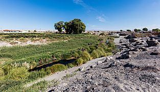
The Loa in Chiu Chiu
-
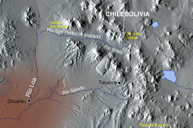
Map showing the Loa river and its left tributaries

.svg)
Related Pages
See also
 In Spanish: Río Loa para niños
