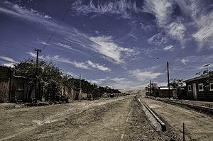
Quillagua facts for kids
Quillagua is a special place called an oasis in northern Chile. It's located in the Tocopilla Province, which is part of the Antofagasta Region. Quillagua is also part of a larger area known as the María Elena commune. The important Loa River flows through this area, and the famous Pan-American Highway crosses it right here.
Quillagua is known for something amazing: it's considered the driest place on Earth! This fact has been confirmed by the Dirección Meteorológica de Chile (Chile's weather service) and even recognized by Guinness World Records. It's even drier than another very dry city in Chile called Arica.
| Climate data for Quillagua (1971-2000) | |||||||||||||
|---|---|---|---|---|---|---|---|---|---|---|---|---|---|
| Month | Jan | Feb | Mar | Apr | May | Jun | Jul | Aug | Sep | Oct | Nov | Dec | Year |
| Mean daily maximum °C (°F) | 26.9 (80.4) |
26.7 (80.1) |
25.3 (77.5) |
23.4 (74.1) |
21.1 (70.0) |
19.1 (66.4) |
18.8 (65.8) |
19.3 (66.7) |
21.4 (70.5) |
22.5 (72.5) |
24.0 (75.2) |
26.0 (78.8) |
22.9 (73.2) |
| Daily mean °C (°F) | 21.9 (71.4) |
21.7 (71.1) |
20.3 (68.5) |
18.4 (65.1) |
16.2 (61.2) |
14.3 (57.7) |
14.0 (57.2) |
14.5 (58.1) |
16.5 (61.7) |
17.6 (63.7) |
19.0 (66.2) |
20.5 (68.9) |
17.9 (64.2) |
| Mean daily minimum °C (°F) | 16.9 (62.4) |
16.8 (62.2) |
15.4 (59.7) |
13.4 (56.1) |
11.3 (52.3) |
9.5 (49.1) |
9.3 (48.7) |
9.8 (49.6) |
11.6 (52.9) |
12.7 (54.9) |
14.0 (57.2) |
15.0 (59.0) |
13.0 (55.3) |
| Average rainfall mm (inches) | 0.05 (0.00) |
0.0 (0.0) |
0.0 (0.0) |
0.0 (0.0) |
0.0 (0.0) |
0.0 (0.0) |
0.0 (0.0) |
0.0 (0.0) |
0.0 (0.0) |
0.0 (0.0) |
0.0 (0.0) |
0.0 (0.0) |
0.05 (0) |
| Source 1: Quillagua climate information | |||||||||||||
| Source 2: Rainfall data | |||||||||||||
What is an Oasis?
An oasis is a fertile spot in a desert where water is found. This water often comes from an underground spring or a river that flows through the dry land, like the Loa River in Quillagua. Oases are very important because they allow plants and animals to live in places that would otherwise be too dry. People also often build towns and villages around oases.
The Loa River and Pan-American Highway
The Loa River is the longest river in Chile. It's a vital water source for the dry northern regions, including Quillagua. The Pan-American Highway is a huge network of roads that connects almost all the countries in the Americas. It's a major route for travel and trade. The fact that this highway crosses the Loa River at Quillagua makes the oasis an important stopping point for travelers.
Why is Quillagua so Dry?
Quillagua is located in the Atacama Desert, which is one of the driest places on Earth. The desert's extreme dryness is due to several factors. One reason is the "rain shadow" effect from the Andes Mountains. These tall mountains block moisture-filled clouds from reaching the desert. Another factor is the cold Humboldt Current in the Pacific Ocean, which cools the air and makes it less likely to form rain clouds.
See also
- 2007 Tocopilla earthquake
- Atacama
 In Spanish: Quillagua para niños
 | Georgia Louise Harris Brown |
 | Julian Abele |
 | Norma Merrick Sklarek |
 | William Sidney Pittman |


