Lascar (volcano) facts for kids
Quick facts for kids Lascar |
|
|---|---|
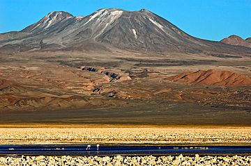
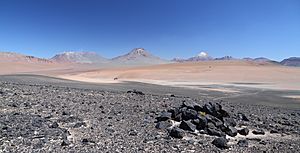
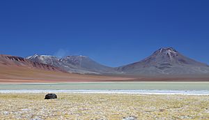
The Lascar volcano, seen from the Chaxas lagoon on the Gran Salar. To the left, in the background, the Aguas Calientes volcano.
|
|
| Highest point | |
| Elevation | 5,592 m (18,346 ft) |
| Geography | |
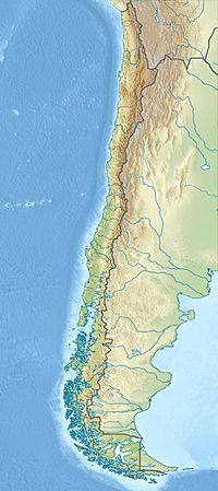
| Location | Northern Chile |
| Parent range | Andes |
| Geology | |
| Mountain type | Stratovolcano |
| Last eruption | December 10, 2022 |
Lascar is a tall, cone-shaped stratovolcano in Chile. It is part of the Andes mountain range. This area is known as the Central Volcanic Zone. Lascar is one of the most active volcanoes in this region. It has been erupting on and off since at least 1848.
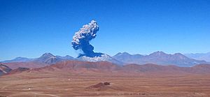
The volcano has two main parts, or cones. Each cone has several openings called craters at the top. The western crater of the eastern cone is currently active. Lascar often releases volcanic gas. Sometimes, it has bigger, explosive eruptions.
Scientists believe Lascar has been active for at least 56,000 years. Some even think it started erupting 220,000 years ago. The first eruptions happened at the eastern cone. They mostly involved slow-moving lava. Later, activity moved to the western cone. Over time, the volcano changed its shape. Today, the eastern cone is the most active part. The hot, melted rock, called magma, comes from deep inside the Earth. It forms when the Nazca Plate slides under the South America Plate. Many other volcanoes are nearby, like Aguas Calientes.
Lascar has had at least three very big eruptions. One was called the Soncor eruption. It happened about 26,450 years ago. Another big eruption was in 7,250 BCE. The most recent large eruption was in April 1993. The 1993 eruption sent ash fall as far as Buenos Aires, Argentina. Because Lascar is in a remote area, scientists mostly watch it from far away. Powerful explosions are the main danger from Lascar.
Contents
What's in a Name?
The name Lascar comes from the Atacameño language. The word láskar or lassi means "tongue". People think this name refers to the volcano's shape. Other names for Lascar include Hlàscar and Toconao.
People and the Volcano
Several towns are located near Lascar. The new town of Talabre is about 17 kilometers (10.5 miles) west of the volcano. In 2012, about 50 people lived there. Toconao is 34 kilometers (21 miles) away. San Pedro de Atacama is about 68 kilometers (42 miles) from Lascar. People in Talabre mostly raise animals and farm. A main road, Chile Route 23, passes about 10 kilometers (6 miles) west of Lascar.
Lascar is a popular place for volcano tourism. However, unlike some other nearby volcanoes, there are no ancient sites found on Lascar. This might be because of its active nature. Some local people, like those in Camar, Chile, see Lascar as a protective mountain spirit. In Susques, Argentina, people believe that if Lascar steams a lot, it will snow. The people of Talabre even give gifts to the volcano. They see it as their source of water.
Where is Lascar Located?
Volcanoes in the Andes
The Andes mountains have four main areas with volcanoes. Lascar is in the Central Volcanic Zone. This zone covers parts of Peru, Bolivia, Argentina, and Chile. These volcanic areas are separated by places where there are no recent volcanoes. This happens when the Earth's plates slide under each other at a shallow angle. This process can stop magma from forming.
The Central Volcanic Zone is the largest of these areas. Volcanoes have been active here for 120 million years. Water from the sliding plate helps create melted rock, or magma. This magma then rises into the Earth's crust.
There are about 122 volcanoes in the Andes that have erupted recently. Many of these volcanoes are covered in snow and ice. Some very large volcanoes, called supervolcanoes, are also found in the Central Volcanic Zone.
Lascar's Neighborhood
Lascar's activity is linked to the Nazca Plate sliding under the South America Plate. The Central Andes has hundreds of volcanoes. Many are over 6,000 meters (19,685 feet) tall. The Earth's crust here is very thick, between 50 and 70 kilometers (31-43 miles).
Lascar is in the Antofagasta Region of Chile. Its height is listed differently by various sources, around 5,592 meters (18,346 feet). The volcano covers an area of 54 square kilometers (21 square miles). It has a volume of about 15 cubic kilometers (3.6 cubic miles).
Lascar is located on the edge of a high plateau called the Altiplano. The Salar de Atacama, a large salt flat, is about 30 kilometers (18.6 miles) to the west. Aguas Calientes volcano is 5 kilometers (3 miles) east of Lascar. It is older than Lascar. They might even share the same magma chamber.
Lascar sits on top of a ridge. This ridge is formed by two lava domes, Cerro Corona and Cerro de Saltar. These domes are about 5 million years old. They are made of volcanic rock called dacite.
Inside Lascar: Geology
Lascar is a steep volcano with two main cones. These cones are shaped a bit unevenly. There are six craters on the volcano. The western cone is no longer active. Its large crater is now filled by another cone. This cone forms the highest point of Lascar.
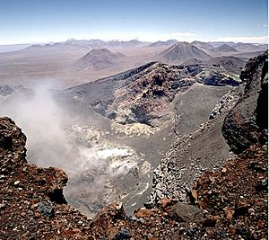
East of the western cone is the active eastern cone. This cone has three distinct craters. The westernmost of these three is the one currently active. It is surrounded by rims up to 150 meters (492 feet) high. In 1985, a hot spot was seen in this crater from space. Inside the active crater, there is an even smaller crater. It is about 310 by 340 meters (1,017 by 1,115 feet) wide. Its depth is about 250 meters (820 feet). The exact shape of the craters changes as the volcano remains active.
Large lava flows can be seen on the sides of the volcano. There are eight main lava flows. None of them seem to come from the currently active crater. One lava flow on the northern side is 6 kilometers (3.7 miles) long. It almost reaches the village of Talabre. This flow is called the Tumbres–Talabre lava flow.
Lascar has also produced pyroclastic flows. These are fast-moving currents of hot gas and volcanic rock. The Soncor flow is found mostly on the western side of Lascar. It was formed by a very large eruption. This flow traveled up to 27 kilometers (16.7 miles) west from the volcano.
The valleys around Lascar were likely shaped by glaciers long ago. These valleys drain water from the volcano's slopes. Traces of ancient glaciers are found on the older parts of Lascar. They are at heights above 4,600 meters (15,090 feet).
What Lascar is Made Of
The rocks from Lascar are mostly andesite and dacite. These are types of volcanic rock. They contain various minerals like plagioclase. The magma that erupts from Lascar seems to be a mix of different types of melted rock. Hotter, more basic magma mixes with older, more developed magma. This mixing happens deep inside the Earth.
Scientists believe Lascar's magma chamber is about 10 to 17 kilometers (6-10.5 miles) deep. However, some signs suggest it might be even deeper. The temperature of the magma chamber is very hot, around 890 to 970 degrees Celsius (1,634 to 1,778 degrees Fahrenheit).
Gases from Lascar
Lascar constantly releases plumes of gas. These plumes often look like white clouds of water vapor. Most of these gases come from hundreds of small vents called fumaroles. These are mainly located in the active crater. The temperature of these vents can range from 40 to over 295 degrees Celsius (104 to 563 degrees Fahrenheit). These vents stay active for years.
Lascar releases a lot of sulfur dioxide gas. This is a common volcanic gas. Lascar is one of the biggest sources of volcanic sulfur dioxide in the world. It releases between 200 and 2,300 tons (440,000 to 5,070,000 pounds) of sulfur per day. This is about 1% of all volcanic sulfur emissions globally. It's similar to the amounts released by volcanoes like Kilauea.
The volcano also releases large amounts of hydrogen chloride and hydrogen fluoride. These are also gases. Lascar is a significant source of these gases globally. It also produces tiny dust particles called sulfate dust.
The gases come from magma deep inside the volcano. The magma interacts with the surrounding rocks. This interaction can change the gases released. The heat from Lascar is very high. It can be between 75 and 765 megawatts during normal activity.
Lascar's Eruptions Over Time
Lascar is one of the three most active volcanoes in the Central Volcanic Zone. It has been erupting steadily for centuries. It usually has a tall plume of water and sulfur dioxide. Most of its activity today is the release of gas. But it also has explosive eruptions every two or three years. These eruptions send columns of ash several kilometers high.
Early Eruptions
The oldest volcanic activity at Lascar happened between 220,000 and 50,000 years ago. The volcano's activity has moved between its eastern and western parts. The eastern part formed first. It erupted lava and pyroclastic flows.
Later, the western part of the volcano became active. It formed a group of lava domes. At one point, an ice cap formed over Lascar. This ice cap fed two glaciers.
The Soncor Eruption
A very large eruption, called the Soncor eruption, happened about 26,450 years ago. It released a huge amount of ash and pyroclastic flows. The eruption column reached 22 to 30 kilometers (13.6 to 18.6 miles) high.
The Soncor pyroclastic flow spread up to 27 kilometers (16.7 miles) west from the volcano. It was very hot, around 800 to 900 degrees Celsius (1,472 to 1,652 degrees Fahrenheit) at the vent. This eruption destroyed the volcano's previous shape.
After Soncor
After the Soncor eruption, a new volcano grew over the old vent. This new volcano was made of lava flows and scoria. This growth happened after a period of erosion. Glaciers in the region were at their largest during this time.
Around 7250 BCE, the Tumbres eruption occurred. It started with ash falling. Then, pyroclastic flows formed. This eruption created a new caldera and two western craters.
Later, activity moved back to the eastern part of the volcano. Around 5150 BCE, the Tumbres-Talabre lava flow erupted. This flow is 8 kilometers (5 miles) long. It was the last time Lascar had a slow lava flow, not counting later lava domes. The three eastern summit craters formed around this time. The deepest of these three is still active today.
Recent Eruptions
Lascar has erupted about thirty times since the 1800s. People have written about its activity since the 1500s. Most recent activity involves gas emissions and occasional explosions. Eruptions happened in 1858, 1875, and 1902. The 1933 eruption was seen from far away.
In 1984, Lascar became more active. Satellites saw hot spots on the volcano. In September 1986, an eruption dropped ash in Salta, Argentina. This explosion was strong enough to wake up sleeping people in Toconao. The eruption cloud reached 9.4 kilometers (5.8 miles) high.
In early 1989, a lava dome formed in the crater. This dome began to shrink. In February 1990, a column of ash rose 8 to 14 kilometers (5 to 8.7 miles) high. Lava bombs, some as big as 1.5 meters (5 feet) wide, were thrown 4 kilometers (2.5 miles) from the crater. Another lava dome formed in 1992. It also shrank and disappeared by March 1993.
Since 1984, Lascar has had a cycle of activity. Gas builds up, then there's an explosion, and then more gas release. This happens because gas can't always escape easily from the magma. Most of the time, many fumaroles in the crater create a plume about 1,000 meters (3,280 feet) high. During smaller eruptions, columns can reach 5,000 meters (16,400 feet).
The 1993 Eruption
A major eruption happened on April 19-20, 1993. It started with smaller explosions on April 18. The main eruption began with two explosions. They formed eruption columns 10 kilometers (6.2 miles) high. The strongest explosion sent a column 23 kilometers (14.3 miles) high. This eruption was similar in size to the 1982 eruption of El Chichon. The lava dome in the crater was destroyed. Lava bombs, some 2 meters (6.5 feet) wide, were thrown 4 kilometers (2.5 miles) away.
The eruption columns collapsed several times. This created pyroclastic flows. These flows reached lengths of 8.5 kilometers (5.3 miles) on the northwest side. They were 5 to 10 meters (16 to 33 feet) thick. The flows moved very fast, up to 700 kilometers per hour (435 mph). They also caused ash surges.
The flows were very powerful. They eroded rocks and material from the ground. It took a long time for these flows to cool down. Ash from the volcano was carried by wind towards Argentina and the Atlantic Ocean. Ash fell in Buenos Aires, 1,500 kilometers (932 miles) away. It also affected air travel.
This 1993 eruption was the biggest at Lascar in 9,000 years. It lasted 32 hours. It changed the volcano's shape. It released about 400,000 tons (880 million pounds) of sulfur dioxide. This was enough to make the atmosphere hazy. The people of Talabre were evacuated. Luckily, no one was hurt. However, the eruption did cause water pollution.
After 1993
After the 1993 eruption, a new lava dome formed. It was larger than previous ones. It started to shrink by May. In December 1993, another explosion created an eruption column 8 to 10 kilometers (5 to 6.2 miles) high. The dome then disappeared.
Explosive eruptions continued in 1994, 1995, and 1996. They sometimes caused ash to fall in Jujuy, Argentina. An eruption in July 2000 was seen from Chuquicamata. The noise was heard 160 kilometers (99 miles) away. It formed a 10 to 11 kilometer (6.2 to 6.8 miles) high eruption column.
More activity happened in May 2005 and April 2006. The 2006 eruption was strong enough to shake windows in Talabre. It was seen from a copper mine 220 kilometers (137 miles) away. It caused ash to fall north of the volcano. The eruption columns reached 10 kilometers (6.2 miles) high.
Weak eruptions with earthquakes and plumes occurred in 2012 and 2013. Glowing was seen at the summit in 2013. The last eruption was on October 30, 2015. It created a 2,500 meter (8,200 feet) high ash column. This caused the volcano alert level to be raised. In December 2022, an explosion generated a 6 kilometer (3.7 miles) high plume. A new lava dome formed inside the active crater in January 2023.
Earthquakes at Lascar
Earthquakes happen at Lascar. Scientists have noticed special patterns. These include "rapid-fire" events and long-period earthquakes. These quakes are linked to strong gas activity, even when there are no big eruptions. Tremors have also been recorded. These might be caused by liquids moving inside the volcano. Except for the 1993 eruption, there haven't been many earthquakes linked to eruptions.
Watching Lascar and Its Dangers
Scientists watch Lascar closely. Because it's so remote, they use remote sensing a lot. This means they use satellites and other tools from far away. Since 2010, a monitoring network has been built around the volcano. This includes gas monitors, seismometers (to detect earthquakes), a weather station, and cameras. They also use drones and occasional flights.
The National Geology and Mining Service of Chile considers Lascar the 14th most dangerous volcano in Chile. They classify it as a "type I" volcano. They also create maps to show where dangers might occur.
Explosive eruptions and ash falls are the biggest threats. Smaller explosions can happen suddenly. This can be dangerous for people on the mountain. Towns like Tumbres and Talabre could be affected by pyroclastic flows. Ash falls could reach San Pedro de Atacama and Toconao. They could also affect roads and observatories. Past eruptions have caused ash to fall in Argentina. This has disrupted air travel.
In 1982, the town of Talabre was moved for safety. This was due to floods and volcanic activity. Large rocks thrown by the volcano are a danger to mountaineers and scientists. Past events like landslides and mudflows have happened. But they are less likely to be a problem today.
Heavy metals from the volcano can be a problem. High levels of arsenic have been found in local crops. Lascar is a major source of arsenic in northern Chile. Thallium and nickel from the volcano can also pollute the area.
Climate and Wildlife
The area around Lascar is one of the driest and highest volcanic places in the world. Lascar gets about 50 to 100 millimeters (2 to 4 inches) of rain each year. Most of this is snow. Snow stays on the western and southern slopes. This snow contributes to the water in the fumaroles. Sometimes, rain can cause steam explosions. Lascar is very close to the Atacama Desert, which is one of the driest deserts on Earth.
During past glacial periods, Lascar likely had small glaciers. The climate became much drier about 8,500 years ago. This caused less erosion.
Temperatures in the region can range from -25 to 40 degrees Celsius (-13 to 104 degrees Fahrenheit). The permanent snowline is now higher than Lascar's summit.
Because of the dry climate, there isn't much plant life on Lascar. Some bunch grass and shrubs grow on its slopes. Deeper valleys have more plants because of groundwater and streams.
Lascar's volcanic activity affects nearby ecosystems. This includes the Aguas Calientes crater lake and Laguna Lejia. Flamingos disappeared from Laguna Lejia after the 1993 eruption. They didn't return until 2007. However, other reports say flamingos stayed. Animals like donkeys and llamas were seen near the volcano even after the eruption.
See also
 In Spanish: Volcán Láscar para niños
- List of volcanoes in Chile
 | Janet Taylor Pickett |
 | Synthia Saint James |
 | Howardena Pindell |
 | Faith Ringgold |


