
Salta Province facts for kids
Quick facts for kids
Salta
|
|||
|---|---|---|---|
|
|||
| Nickname(s):
La Linda (The beautiful)
|
|||

Location of Salta Province within Argentina
|
|||
| Country | Argentina | ||
| Capital | Salta | ||
| Departments | 23 | ||
| Municipalities | 58 | ||
| Area | |||
| • Total | 155,488 km2 (60,034 sq mi) | ||
| Population
(2010)
|
|||
| • Total | 1,214,441 | ||
| • Rank | 8th | ||
| • Density | 7.810513/km2 (20.22914/sq mi) | ||
| Demonym(s) | salteño/a | ||
| Time zone | UTC−3 (ART) | ||
| ISO 3166 code | AR-A | ||
| HDI (2016) | 0.830 Very High (19th) | ||


Salta is a province in Argentina. It is located in the northwest part of the country. It shares borders with other Argentine provinces like Formosa, Chaco, Santiago del Estero, Tucumán, and Catamarca. It completely surrounds Jujuy Province. To the north, Salta borders Bolivia and Paraguay, and to the west, it borders Chile.
Contents
History of Salta Province
Before the Spanish arrived, many native groups lived in the valleys of what is now Salta Province. These included the Diaguitas and Calchaquíes. They formed different tribes, like the Quilmes and Humahuacas, who all spoke the Cacán language. The Atacamas lived in the Puna region, and the Wichís lived in the Chaco area.
Early Explorers and Founding
The first Spanish explorer to visit this area was Diego de Almagro in 1535. He was followed by Diego de Rojas. In 1582, Hernando de Lerma founded a city called San Felipe de Lerma. He did this under orders from the viceroy Francisco de Toledo, Count of Oropesa. The city's name soon changed to "San Felipe de Salta." By 1650, about 500 people lived in the city.
.jpg)
A special administrative area called "Salta del Tucumán" was created within the Viceroyalty of the Río de la Plata. In 1774, the city of San Ramón de La Nueva Orán was founded between Salta and Tarija. Tarija was added to this area later in 1807. In 1783, because Salta was becoming more important, its capital was moved from San Miguel de Tucumán to Salta.
Independence and Border Changes
The Battle of Salta in 1813 helped free the area from Spain. However, attacks from the Viceroyalty of Peru continued until 1826. In 1814, Gervasio de Posadas created the Province of Salta. This province included the current Salta and Jujuy provinces, plus parts of southern Bolivia and northern Chile.
After Argentina gained independence, there were some internal conflicts. Bolivia took advantage of this and annexed Tarija in 1826. In 1834, Jujuy separated from Salta and became its own province. Salta's borders became even smaller in 1900 when Yacuiba was lost to Bolivia.
In 1902, the National Government of Los Andes was formed from part of Salta Province. Its capital was San Antonio de los Cobres. This area was returned to Salta Province in 1943 and became the Department of Los Andes.
A famous painting by Antonio Alice, called La muerte de Güemes, shows the death of a local hero. This painting won a Gold Medal at the Centenary Exposition and is now in the Salta Provincial Government offices.
Geography and Landscape
Salta Province covers about 155,488 square kilometers (59,996 square miles). This makes it the sixth largest province in Argentina. The main rivers in the province are the Pilcomayo, Bermejo, and the Juramento. The Juramento River later becomes the Salado River.

Salta Province is in an area where the Earth's plates are active. Because of this, it sometimes experiences earthquakes. There have been four notable earthquakes in the province:
- In 1692, a strong earthquake registered 7.0 on the Richter scale.
- In 1844, another earthquake registered 6.5 on the Richter scale.
- In 1948, a powerful earthquake registered 7.0 on the Moment magnitude scale.
- In 2010, a more recent earthquake registered 6.1 or 6.3 on the Moment magnitude scale.
The 1692 earthquake inspired Salta's yearly citywide festival. It is held on September 16 to honor El Señor y la Virgen del Milagro.
Climate Zones
Salta Province is in the tropical zone. This means it generally has a warm climate. However, the climate changes a lot due to different altitudes. The way the Andes mountains are shaped also affects where rain falls in the province.
Eastern Plains Climate
The easternmost parts of Salta have a semi-arid climate. This means they have a dry winter. The average yearly temperature is about 20°C (68°F), and it receives about 500 mm (20 inches) of rain. Temperatures can reach up to 47°C (117°F) in summer. In winter, they can drop to -5°C (23°F).
Andean Slopes Climate
The first slopes of the Andes mountains cause moist winds from the east to rise. This creates a lot of clouds and heavy rain. These eastern slopes get between 1,000 to 1,500 mm (39 to 59 inches) of rain each year. Some places get up to 2,500 mm (98 inches) because of mountain-induced rainfall. Most of the rain falls in summer, and winters are dry. The heavy rainfall on these slopes creates a thick jungle. This narrow strip of jungle has many different kinds of plants and animals. Higher up on these slopes, the climate is cooler and more humid. Here, you will find deciduous and pine trees.
Valley Climate
Between the high mountains to the west and the low plains to the east are the valleys. The climate in these valleys is mild. This makes them good places for people to live and for farming. The average yearly rainfall is about 1,000 mm (39 inches), mostly in summer. Average temperatures are above 20°C (68°F) in summer. In winter, they are below 14°C (57°F).
High Plateau Climate
Further west is the Altiplano, a high plateau. It is 3,000 to 4,000 meters (9,800 to 13,100 feet) above sea level. The climate here is dry and cold. High temperatures do not change much, ranging from 14°C to 21°C (57°F to 70°F). Night temperatures go from 6°C (43°F) in midsummer to -8°C (18°F) in midwinter. They can even drop below -15°C (5°F). All the rain falls only in summer, with totals between 200 mm and 400 mm (8 to 16 inches). Several salt flats are found in this area.
Highest Altitudes Climate
At the very highest parts of western Salta, the climate is very dry and cold. There are big temperature changes between day and night.
Economy of Salta
Salta's economy is not as developed as some other parts of Argentina, but it is quite varied.
Manufacturing and Resources
Manufacturing is an important part of Salta's economy, adding 20% to its total output. Natural gas and oil from areas like Tartagal, Aguas Blancas, Madrejones, and Campo Durán are sent through pipes to Buenos Aires and Rosario. There is also an oil refinery at Campo Durán. Mining activities include finding uranium in places like Iruya, La Poma, and San Carlos.
Agriculture and Farming
Farming and related industries are still very important in Salta. They contribute over 10% to the province's production. Tobacco, sugar cane, and wine production are the most important crops. They make up most of the exports from the area. Other crops grown mostly for local use include maize (corn), beans, citrus fruits, bananas, and tomatoes.
Sugar cane is processed in plants in Salta before being sent to other parts of Argentina and other countries. The plant in San Martín de Tabacal is the largest one. The famous wines from the Valles Calchaquíes region, especially near Cafayate, are made in many different vineyards. These wines are mainly Torrontés, Malbec, and Cabernet Sauvignon. American breeds of cattle are raised only in the humid, subtropical east. Some sheep and goats are also raised there.
Tourism in Salta
Salta Province has many interesting natural, social, and historical places to visit.
Salta City Attractions
The city of Salta is known as La Linda (meaning "The beautiful"). It is a major tourist spot and a great starting point for exploring the rest of the province. The city itself has many attractions. These include its old colonial houses and its beautiful cathedral. The Museo de Arqueología de Alta Montaña de Salta (High Mountain Archaeology Museum of Salta) is also there. This museum displays three frozen Inca mummies known as the Children of Llullaillaco. These mummies were found on the Llullaillaco volcano.
Natural Wonders and Adventures
The Tren a las Nubes ("Train to the Clouds") is a famous train ride. It crosses deep canyons and high cliffs. It reaches an altitude of 3,775 meters (12,500 feet) at San Antonio de los Cobres. The red-rock formations of the Valles Calchaquíes and the wine-making town of Cafayate are the second most visited places in the province. Many people also visit the Cachi mountains and the small villages around them, like Payogasta.
National Parks
Salta has three national parks. These are El Rey National Park in the Yungas jungle, Baritú National Park, and Los Cardones National Park. These parks protect the diverse nature and wildlife of the region.

Images for kids
-
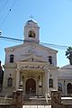
The Antiochian Orthodox Saint George Church.

See also
 In Spanish: Provincia de Salta para niños
