
Tarija facts for kids
Quick facts for kids
Tarija
|
|||
|---|---|---|---|
|
City & Municipality
|
|||
 .jpg)   .jpg)  .jpg) .jpg) From the top, left to right: Casa Dorada, Metropolitan Cathedral of Tarija, Plaza de Armas Luis de Fuentes y Vargas, Paleontology Museum, Vineyards in the Tarija Valley, Traditional adobe structure, Municipal government of Tarija
|
|||
|
|||

Tarija
Location in Bolivia

Tarija
Location in South America
|
|||
| Country | |||
| Department | Tarija | ||
| Province | Cercado | ||
| Founded | July 4, 1574 | ||
| Elevation | 1,854 m (6,083 ft) | ||
| Population
(2012 Census)
|
|||
| • Urban | 268,000 | ||
| • Metro | 330,000 | ||
| Time zone | UTC-4 (BOT) | ||
| Area code(s) | 4 | ||


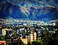
Tarija, also known as San Bernardo de la Frontera de Tarixa, is a lively city in southern Bolivia. It was founded a long time ago, in 1574. Tarija is the biggest city and the capital of the Tarija Department.
The city has its own airport, Capitán Oriel Lea Plaza Airport (TJA). This airport offers regular flights to other major cities in Bolivia. Tarija also has a bus station that connects it to places within Bolivia and other countries.
Tarija has a warm, semi-arid climate. This means it's often sunny and not too cold, unlike the high plains of Altiplano (like La Paz). It's also not as hot and humid as the Amazon Basin (like Santa Cruz de la Sierra). About 234,442 people live in Tarija.
Contents
History of Tarija
How Tarija Got Its Name
The name Tarija might come from a person named Francisco de Tarija or Tarifa. However, historical records show that no one with that name was part of the group that explored the area. There are other similar names for nearby places, such as Tariquia and Taxara. This suggests the name might have an older origin.
Becoming Part of Bolivia
In 1826, the people of Tarija voted to become part of Bolivia. Before this, in 1807, Tarija had been separated from Upper Peru (which later became Bolivia). It was made part of Salta Province in Argentina. But because Tarija had strong connections to Bolivia, it returned to its original area. Later, in 1899, Argentina gave up its claims to Tarija in exchange for another area called Puna de Atacama.
Early Inhabitants of the Valley
The valley where Tarija is located was first home to native groups like the Churumatas. Later, the Inca Empire, led by the Quechua people, took over the land. They moved the Churumatas and other local groups to different parts of the Andes. The Incas called these moved groups Mitimaes.
The Tomatas group is believed to have been brought to the San Juan del Oro River area near Tarija from Norte Chico, Chile. The Tomatas might have named new places in Bolivia after places from their old home in Chile. This could explain why names like Loa, Calama, and Erqui (Elqui) are found in Bolivia. In 1574, a Spanish explorer named Luis de Fuentes settled the Tomatas near the city of Tarija.
When the Spanish first arrived in the Tarija valley, they found old stone roads. These roads were likely built by cultures that lived there before the Incas, such as the Churumatas. However, at that time, not many native people lived in the valley. Some of these old roads and trails are still preserved today. Locals in Tarija, called Tarijeños, use them for walking.
Things to Do and See in Tarija
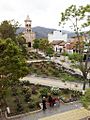
Tarija's main plaza is a popular spot. It's surrounded by many restaurants, shops selling local crafts, and internet cafes. Close by, you can find a public market, a university campus, and several tourist attractions. One popular place is the Paleontology Museum of Tarija City. The city also has fancier restaurants, fast food places, and dance clubs.
Exploring Beyond the City
From Tarija, you can travel in many directions:
- To the east, you can go to Paraguay or the Gran Chaco region, passing through Yacuiba.
- To the south, you can reach Argentina through Bermejo, Yacuiba, or Villazón.
- To the west, you can travel to Tupiza and the famous Salar de Uyuni salt flats, going through Villazón.
- To the north, you can reach the central cities of Bolivia, like Potosí.
Traveling to the high plains and Potosí is now much safer. A new tunnel helps travelers avoid the Sama mountain, which is just west of Tarija.
Natural Attractions
The San Jacinto Dam is located a few kilometers south of Tarija. It's a great place to visit. The Chorros de Jurina falls, a beautiful waterfall, is a few kilometers northwest of the city.
Tarija's land and climate are perfect for growing grapes and making wine. The city even hosts an annual Festival of Wine, celebrating its delicious local wines.
Tarija's Climate
Tarija has a semi-arid climate, which means it's generally dry but can have some rain. It's also close to a subtropical highland climate. Summers in Tarija are warm and often humid. Winters, however, are very dry with almost no rain. During winter, daytime temperatures are warm, but nights can be cooler.
Most of the yearly rainfall happens during the summer months in the Southern Hemisphere. Sometimes, light frosts can occur from May to October. On July 25, 2019, Tarija experienced its heaviest snowfall since 1954, which was a rare event!
| Climate data for Tarija Airport, elevation: 1,875 metres (6,152 ft), 1981–2010 normals, extremes 1962–present) | |||||||||||||
|---|---|---|---|---|---|---|---|---|---|---|---|---|---|
| Month | Jan | Feb | Mar | Apr | May | Jun | Jul | Aug | Sep | Oct | Nov | Dec | Year |
| Record high °C (°F) | 36.5 (97.7) |
37.4 (99.3) |
37.5 (99.5) |
37.3 (99.1) |
36.9 (98.4) |
35.1 (95.2) |
36.0 (96.8) |
37.4 (99.3) |
39.5 (103.1) |
39.7 (103.5) |
37.8 (100.0) |
38.8 (101.8) |
39.7 (103.5) |
| Mean daily maximum °C (°F) | 27.1 (80.8) |
26.6 (79.9) |
26.6 (79.9) |
25.9 (78.6) |
24.8 (76.6) |
24.4 (75.9) |
23.9 (75.0) |
25.6 (78.1) |
26.1 (79.0) |
27.5 (81.5) |
27.4 (81.3) |
27.5 (81.5) |
26.1 (79.0) |
| Daily mean °C (°F) | 20.8 (69.4) |
20.3 (68.5) |
20.2 (68.4) |
18.6 (65.5) |
15.5 (59.9) |
13.6 (56.5) |
13.2 (55.8) |
15.4 (59.7) |
17.0 (62.6) |
19.7 (67.5) |
20.3 (68.5) |
21.0 (69.8) |
18.0 (64.4) |
| Mean daily minimum °C (°F) | 14.7 (58.5) |
14.1 (57.4) |
13.8 (56.8) |
11.3 (52.3) |
6.3 (43.3) |
2.7 (36.9) |
2.5 (36.5) |
5.2 (41.4) |
7.9 (46.2) |
11.9 (53.4) |
13.3 (55.9) |
14.4 (57.9) |
9.8 (49.6) |
| Record low °C (°F) | 6.0 (42.8) |
4.0 (39.2) |
5.0 (41.0) |
−2.0 (28.4) |
−3.0 (26.6) |
−7.7 (18.1) |
−9.2 (15.4) |
−8.0 (17.6) |
−4.2 (24.4) |
0.0 (32.0) |
3.0 (37.4) |
0.0 (32.0) |
−9.2 (15.4) |
| Average precipitation mm (inches) | 130.2 (5.13) |
100.4 (3.95) |
90.3 (3.56) |
16.1 (0.63) |
1.7 (0.07) |
0.2 (0.01) |
0.3 (0.01) |
1.9 (0.07) |
7.0 (0.28) |
37.1 (1.46) |
73.2 (2.88) |
125.9 (4.96) |
584.3 (23.00) |
| Average precipitation days | 14.8 | 12.5 | 11.2 | 4.0 | 1.1 | 0.3 | 0.3 | 0.9 | 2.6 | 6.8 | 10.4 | 12.8 | 77.6 |
| Average relative humidity (%) | 67.1 | 68.9 | 68.6 | 65.6 | 58.9 | 53.0 | 51.9 | 50.0 | 50.8 | 54.6 | 59.6 | 64.1 | 59.2 |
| Source: Servicio Nacional de Meteorología e Hidrología de Bolivia | |||||||||||||
| Climate data for Tarija | |||||||||||||
|---|---|---|---|---|---|---|---|---|---|---|---|---|---|
| Month | Jan | Feb | Mar | Apr | May | Jun | Jul | Aug | Sep | Oct | Nov | Dec | Year |
| Mean daily maximum °C (°F) | 28.5 (83.3) |
27.2 (81.0) |
26.3 (79.3) |
25.5 (77.9) |
24.3 (75.7) |
21.6 (70.9) |
23.3 (73.9) |
24.9 (76.8) |
27.2 (81.0) |
27.8 (82.0) |
27.5 (81.5) |
28.8 (83.8) |
26.1 (78.9) |
| Daily mean °C (°F) | 21.8 (71.2) |
20.7 (69.3) |
19.6 (67.3) |
17.9 (64.2) |
15.4 (59.7) |
12.2 (54.0) |
12.6 (54.7) |
14.5 (58.1) |
17.4 (63.3) |
19.5 (67.1) |
20.0 (68.0) |
21.3 (70.3) |
17.7 (63.9) |
| Mean daily minimum °C (°F) | 15.0 (59.0) |
14.2 (57.6) |
12.9 (55.2) |
10.4 (50.7) |
6.6 (43.9) |
2.8 (37.0) |
2.0 (35.6) |
4.1 (39.4) |
7.7 (45.9) |
11.3 (52.3) |
12.6 (54.7) |
13.8 (56.8) |
9.5 (49.0) |
| Average rainfall mm (inches) | 125 (4.9) |
107 (4.2) |
75 (3.0) |
24 (0.9) |
2 (0.1) |
2 (0.1) |
0 (0) |
3 (0.1) |
6 (0.2) |
34 (1.3) |
65 (2.6) |
113 (4.4) |
556 (21.8) |
| Source: Climate-Data.org | |||||||||||||
Tarija's Culture and People
The "Bolivian Andalusia"
Tarija is often called the "Bolivian Andalusia" by both Bolivians and tourists. This is because it shares some similarities with the Andalusia region in Spain. For example, the Guadalquivir River that flows near the city was named after a famous Spanish river.
Who Are the Chapacos?
People who live in Tarija call themselves Chapacos. This name is used by everyone, no matter their background. The exact origin of the name is not certain. One idea is that it comes from chacapa, which was the name of a native settlement in the area long ago.
Tarijeños and Their Identity
After Bolivia's revolution, the Chapacos chose to be part of Bolivia instead of Argentina. Because of this, people from Tarija are seen as very loyal and patriotic to Bolivia.
However, the culture in modern Tarija is a bit different from other big cities in Bolivia. Many Tarijeños feel a strong connection to Tarija itself, even more than to the rest of Bolivia. Their local pride is shown in a well-known folk song called "Chapaco Soy".
Sports in Tarija
The city's Guadalquivir Coliseum is a major sports venue. It has hosted games for Bolivia's national basketball team. This shows Tarija's role in Bolivian sports.
Sister Cities
Tarija has special connections with other cities around the world. These are called "sister cities" or "twin towns". They often share cultural or historical ties.
 Mejillones, Chile
 Brasschaat, Belgium
- Tournai, Belgium
 Iniesta, Spain
 Salta, Argentina
- Villa Carlos Paz, Argentina
- Mendoza, Argentina
 Asunción, Paraguay
- San Bernardino, Paraguay
Images for kids
-
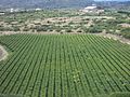
Vineyards in Tarija, Bolivia
-
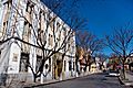
Plaza de Armas, Tarija
-
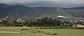
Capitán Oriel Lea Plaza Airport
-
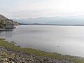
San Jacinto Lake, Tarija
-
Entre Rios Square, Tarija
-
Tarija, Bolivia
-
Tarija, Bolivia

_-_Tarija_-_Bolivia.jpg)


See also
 In Spanish: Tarija para niños
