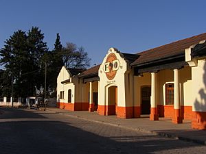
Yacuiba facts for kids
Quick facts for kids
Yacuiba
|
||
|---|---|---|
|
City
|
||
 |
||
|
||
| Country | ||
| Department | Tarija | |
| Province | Gran Chaco | |
| Municipality | Yacuiba Municipality | |
| Canton | Yacuiba Canton | |
| Elevation | 650 m (2,130 ft) | |
| Population
(2012)
|
||
| • Total | 108,578 | |
| Time zone | UTC-4 (BOT) | |
| Website | Official website: http://www.gmyacuiba.gob.bo/ | |
Yacuiba is a city in southern Bolivia. It is the capital of Gran Chaco Province in the Tarija Department. The city is very close to the border with Argentina, only three kilometers away. About 108,578 people lived there in 2012. Yacuiba is located between 620 and 680 meters (about 2,034 to 2,231 feet) above sea level.
Yacuiba is growing fast. This is because of its busy trade and the discovery of natural gas (hydrocarbons) nearby. The city used to be part of Salta Province of Argentina. It became part of Bolivia in 1900.
Because it is on the border, Yacuiba is a big center for trade. Right across the border is Salvador Mazza. These two towns are connected and form one large urban area.
The city has direct roads to Tarija and Santa Cruz. It also has an international airport (BYC). Even though Yacuiba is not a huge city, it has a professional football team called Petrolero in the Bolivian league.
Climate in Yacuiba
Yacuiba has a special kind of weather. It is called a dry-winter humid subtropical climate. This means it has warm, wet summers and mild, dry winters. The city's elevation makes its temperatures a bit cooler than nearby areas.
| Climate data for Yacuiba, elevation 580 m (1,900 ft) | |||||||||||||
|---|---|---|---|---|---|---|---|---|---|---|---|---|---|
| Month | Jan | Feb | Mar | Apr | May | Jun | Jul | Aug | Sep | Oct | Nov | Dec | Year |
| Mean daily maximum °C (°F) | 31.4 (88.5) |
30.4 (86.7) |
28.7 (83.7) |
25.6 (78.1) |
23.1 (73.6) |
21.1 (70.0) |
22.5 (72.5) |
25.6 (78.1) |
27.9 (82.2) |
30.4 (86.7) |
31.0 (87.8) |
31.5 (88.7) |
27.4 (81.4) |
| Daily mean °C (°F) | 25.3 (77.5) |
24.6 (76.3) |
23.4 (74.1) |
20.7 (69.3) |
17.9 (64.2) |
15.5 (59.9) |
15.2 (59.4) |
17.5 (63.5) |
20.2 (68.4) |
23.3 (73.9) |
24.3 (75.7) |
25.2 (77.4) |
21.1 (70.0) |
| Mean daily minimum °C (°F) | 19.3 (66.7) |
18.9 (66.0) |
18.1 (64.6) |
15.7 (60.3) |
12.7 (54.9) |
9.9 (49.8) |
8.0 (46.4) |
9.4 (48.9) |
12.4 (54.3) |
16.2 (61.2) |
17.7 (63.9) |
19 (66) |
14.8 (58.6) |
| Average precipitation mm (inches) | 203.1 (8.00) |
189.3 (7.45) |
192.2 (7.57) |
99.4 (3.91) |
33.9 (1.33) |
18.0 (0.71) |
6.0 (0.24) |
7.4 (0.29) |
10.0 (0.39) |
50.1 (1.97) |
114.7 (4.52) |
173.3 (6.82) |
1,097.4 (43.2) |
| Average precipitation days | 10.5 | 10.1 | 11.0 | 10.1 | 7.2 | 5.4 | 2.8 | 1.5 | 2.2 | 5.3 | 8.1 | 9.6 | 83.8 |
| Average relative humidity (%) | 71.8 | 74.3 | 78.1 | 80.7 | 79.4 | 77.9 | 69.0 | 59.1 | 54.6 | 57.5 | 62.9 | 67.7 | 69.4 |
| Source: Servicio Nacional de Meteorología e Hidrología de Bolivia | |||||||||||||
Meaning of the Name
The name Yacuiba comes from the Guaraní language. It means "fowls' watering hole." This suggests it was a place where birds would come to drink water.
See also
 In Spanish: Yacuiba para niños
 | Kyle Baker |
 | Joseph Yoakum |
 | Laura Wheeler Waring |
 | Henry Ossawa Tanner |


