
Pilcomayo River facts for kids
Quick facts for kids Pilcomayo |
|
|---|---|

Pilcomayo River, seen in Bolivia
|
|

|
|
| Other name(s) | Ysyry Araguay |
| Countries | |
| Physical characteristics | |
| Main source | Most distant source of Pilcomayo-Pilaya-Camblaya-San Juan-Orosmayo-Ajedrez-Porvenir System East slopes of Cerro Sipisami, Jujui Province, Argentina approximately 4800 m approximately 22°51′52″S 66°32′55″W / 22.86444°S 66.54861°W |
| 2nd source | Most distant source of main stem Pilcomayo Municipio Santiago de Huari, Oruro, Bolivia 4820 metres 19°23′36″S 66°25′5″W / 19.39333°S 66.41806°W |
| River mouth | Confluence with Paraguay River Near Asunción, Paraguay 25°16′40″S 57°40′16″W / 25.27778°S 57.67111°W |
| Official name: Rio Pilcomayo | |
| Designated: | 4 May 1992 |
| Reference #: | 557 |
The Pilcomayo River is a long river in central South America. Its name comes from the Quechua language, where Pillkumayu means "red river." It is also known as Ysyry Araguay in the Guarani language.
The Pilcomayo River is about 1,100 kilometers (680 miles) long. This makes it the longest river that flows into the Paraguay River from the west. The area of land that drains into the Pilcomayo River is huge, covering about 270,000 square kilometers (104,000 square miles).
Contents
Where the Pilcomayo River Starts and Flows
The Pilcomayo River begins high up in the Andes mountains. It starts in the Oruro Department of Bolivia, east of Lake Poopó. The Jach'a Juqhu River is thought to be the very beginning of the Pilcomayo. Before it becomes the Pilcomayo, this river has other names like Aguas Calientes and Kachi Mayu.
Journey Through Three Countries
After joining with the Chillawa River, it officially becomes the Pilcomayo. From there, it flows southeast through different parts of Bolivia. These include the Chuquisaca and Tarija departments.
The river then enters Argentina, flowing through the Formosa region. It also crosses the wide, flat Gran Chaco plains in Paraguay. For much of its journey, the Pilcomayo forms a natural border between Argentina and Paraguay. It also forms a small part of the border between Argentina and Bolivia.
Finally, the Pilcomayo River joins the Paraguay River near the city of Asunción. On the Argentine side of the border, you can find the Río Pilcomayo National Park. This park helps protect the natural environment around the river.
River Branches and Silting
As the Pilcomayo flows, it carries a lot of mud and sand. This causes the river to sometimes split into two main parts: a North branch and a South branch. After flowing separately for some distance, these branches often come back together to form the Lower Pilcomayo. This process is called silting up.
People Living Along the River
Many people live in the area around the Pilcomayo River. About 1.5 million people call this river basin home.
- Around 1 million people live in Bolivia.
- About 300,000 people live in Argentina.
- Roughly 200,000 people live in Paraguay.
The Nakotoi Tribe
One of the groups of people living near the Pilcomayo River are the Nakotoi Tribe. They live in the southern part of the river region in central Paraguay. The Nakotoi people are known for their traditional ways of life.
Historically, the Nakotoi Tribe had different relationships with their neighboring tribes, such as the Tobas and Nimká. These interactions sometimes led to conflicts, which meant the Nakotoi had less direct contact with European settlers in the late 1800s.
Nakotoi men are often described as tall and slender, built for hunting and traditional activities. The women are generally shorter. Traditionally, the Nakotoi people wore a rug fastened around their waist.
Images for kids
-
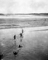
Local fishermen with fishing nets crossing Rio Pilcomayo in 1908.
-
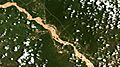
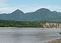
Pilcomayo River as seen through Tarija Department, Bolivia.
-
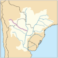
Pilcomayo River highlighted within the Paraná River drainage basin.
-
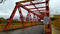
San Ignacio Bridge over Pilcomayo River, between Clorinda (Argentina) and José Falcon (Paraguay).
-
A 19th century footbridge over the Pilcomayo River in Bolivia, on Route 5.
-
Pilcomayo Valley, near Villamontes, Bolivia.
-
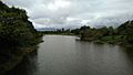
Pilcomayo River, near Asunción.


.jpg)


See also
 In Spanish: Río Pilcomayo para niños
- List of rivers of Argentina
- List of rivers of Paraguay
- List of rivers of Bolivia
- Oroncota, an old settlement and fortress in the Pilcomayo River valley.
- Gran Chaco
Sources
- Kerr, Graham. A Naturalist in the Gran Chaco. Cambridge: Cambridge UP, 1950.
- Pilcomayo River. (2010). In Encyclopædia Britannica. Retrieved January 18, 2010, from Encyclopædia Britannica Online: http://www.britannica.com/EBchecked/topic/460371/Pilcomayo-River
- W. H. Strosnider, F. Llanos, R.W. Nairn: LEGACY OF NEARLY 500 YEARS OF MINING IN POTOSÍ, BOLIVIA: STREAM WATER QUALITY (pdf) - conference paper at the 2008 National Meeting of the American Society of Mining and Reclamation. New Opportunities to Apply Our Science, June 14–19, Richmond, VA.
