Lake Poopó facts for kids
Quick facts for kids Lake Poopó |
|
|---|---|
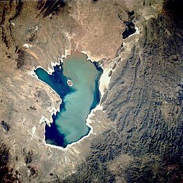
Aerial photograph of the lake in 1991
|
|
| Location | Altiplano |
| Coordinates | 18°33′S 67°05′W / 18.550°S 67.083°W |
| Type | Endorheic salt lake |
| Native name | Lago Poopó (Spanish) |
| Primary inflows | River Desaguadero |
| Primary outflows | evaporation |
| Catchment area | 27,700 km2 (10,700 sq mi) |
| Basin countries | Bolivia |
| Surface area | 1,000 km2 (390 sq mi) |
| Average depth | >1 m (3 ft 3 in) |
| Surface elevation | 3,686 m (12,093 ft) |
| Settlements | Oruro Challapata, Huari |
| Official name: Lagos Poopó y Uru Uru | |
| Designated: | 11 July 2002 |
| Reference #: | 1181 |
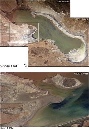
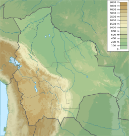
Lake Poopó (in Spanish, Lago Poopó) was a large salt lake in a shallow area of the Altiplano Mountains in Oruro Department, Bolivia. It was located at an elevation of about 3,700 meters (12,100 feet) above sea level. The lake was very long and wide, measuring about 90 by 32 kilometers (56 by 20 miles). It covered the eastern part of the Oruro department, which is known for mining in southwest Bolivia.
The main part of the lake usually covered about 1,000 square kilometers (390 square miles). This made it the second-largest lake in Bolivia. Most of its water came from the Desaguadero River, which flows from Lake Titicaca in the north. Lake Poopó did not have a major river flowing out of it. Its average depth was less than 3 meters (10 feet), so its size changed a lot with the seasons.
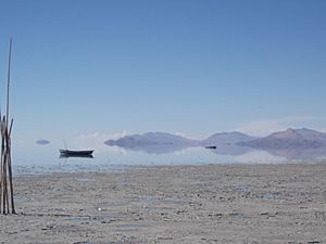
In 2002, Lake Poopó was recognized as an important place for nature conservation under the Ramsar Convention. However, by December 2015, the lake had completely dried up. Only a few marshy areas were left. The lake had dried up completely twice before in history, but this time it seems unlikely to recover. Scientists believe the reasons for its disappearance include melting glaciers in the Andes, long droughts caused by climate change, and too much water being taken for mining and farming.
Ancient Life Around Lake Poopó
Long ago, people lived around Lake Poopó. Studies by the San Andrés University in La Paz, Bolivia, show that the Wankarani culture lived in the Poopó area. They built complex villages and towns that spread into the Poopó basin between 200 BC and 200 AD. This likely happened as farming methods changed.
People who raised llamas and traveled as merchants lived alongside farmers. They worked together, trading goods and services. Later, between 300 and 900 AD, the size of these settled areas grew. People living in the southern part of Poopó developed a special style of pottery with triangular spirals. In the eastern part of the lake, there is evidence of an important Tiwanaku settlement. Their pottery styles show that different groups of people interacted in the area.
How Lake Poopó Worked
Most of Lake Poopó's water (about 92%) came from the Desaguadero River. This river flows south from Lake Titicaca and enters Lake Poopó at its northern end. Many smaller streams also flow into the lake along its eastern side, but most of these are dry for much of the year. When water levels were very high, Lake Poopó would connect to the salt desert called Salar de Coipasa to the west. A small channel also led to Salar de Uyuni further south.
Because the lake had no major river flowing out, it is called an endorheic basin. This means water flows in, but only leaves by evaporating into the air.
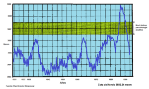
When the water level of Lake Titicaca drops below 3,810 meters (12,500 feet), the Desaguadero River does not bring enough water to Lake Poopó. At this point, the lake starts to shrink because of the huge amount of water lost to evaporation. In 1986, the lake was at its largest, covering 3,500 square kilometers (1,350 square miles). After that, its size steadily decreased until 1994, when it completely disappeared. From 1975 to 1992 was the longest time in recent history that the lake had water all the time. New rainfalls in the mid-1990s brought the lake back to life.
Efforts were made to help the area's environment recover, with money from the European Union. But these efforts could not stop other changes. Since 1995, local temperatures have risen, causing evaporation rates to triple. Also, water was taken for mining and irrigation, making the problems worse. On January 20, 2016, the Bolivian government declared the area a disaster zone.
Why Lake Poopó is Salty
The water in Lake Poopó was very salty. This is because it is an endorheic basin. All the salts and minerals washed into the lake from the surrounding land stay there. The dry climate and high evaporation also made the lake even saltier.
In the northern part of Lake Poopó, the water was less salty because of the fresh water flowing in from the Desaguadero River. The water became saltier as you moved towards the south. The amount of salt changed with the water level. For example, in late 2006, the northern part of the lake was brackish (slightly salty), while the southern part was a very strong brine (extremely salty).
Natural sources of salt, like halite and feldspars, are found in the area around the lake. These also added to the lake's saltiness. The lake sits on top of ancient sediments from huge prehistoric lakes that covered the Altiplano during past ice ages.
Mining and Water Quality
Mining has been a part of the Poopó Basin for a very long time. The Incas mined metals there in the 13th century. After the Spanish arrived in the 16th century, mining grew much larger. This region became one of Bolivia's main mining areas.
The mining areas are located in the mountains along the eastern edge of the Poopó basin. The most important metals mined there are silver and tin.
Studies have shown high levels of heavy metals in the surface and ground waters of the Poopó basin. These metals are naturally found in the rocks, and they are released when the rocks break down. Mining activities make this problem worse. Acid from mines and the process of crushing ore speed up the release of these metals.
Most of the heavy metals that reached Lake Poopó seemed to settle in the bottom mud. However, levels of arsenic, lead, and cadmium in the lake water were higher than the safe limits for drinking water set by Bolivia and the World Health Organization.
Animals and Plants of Lake Poopó
There were only three types of fish found in Lake Poopó: two native species, the pupfish Orestias agassizii and the catfish Trichomycterus rivulatus, and one introduced species, the silverside Odontesthes bonariensis. The lake used to have many fish, but by 2017, pollution and the lake drying up had almost completely destroyed the local fishing industry.
The lake was home to a wide variety of water birds, with 34 different species. The most famous were the three types of flamingos: the Andean, James's, and Chilean flamingos. They mostly lived in the shallow lagoons in the northern and eastern parts of the lake. A bird survey in 2000, done with BirdLife International, found 6 threatened species and other species that were near-threatened. These included the Andean flamingo and the Andean condor.
About 17 types of higher plants and 3 types of algae were found in and around Lake Poopó. Because of the constant drying and flooding, the areas along the shore were often disturbed. This meant there was hardly any plant life growing right on the lake's edges.
Impact of the Lake's Disappearance
The small communities living near Lake Poopó have suffered greatly. Their culture and money depended on fishing in the lake. Also, many bird species, both from Bolivia and those that migrate from other countries, have been affected. They have lost their food sources and an important area where they used to live during their yearly migrations.
See also
 In Spanish: Lago Poopó para niños
 | Toni Morrison |
 | Barack Obama |
 | Martin Luther King Jr. |
 | Ralph Bunche |


