
Tiwanaku facts for kids
.jpg)
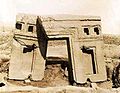
The "Gate of the Sun"
|
|

Location in Bolivia
|
|
| Alternative name | Tiahuanaco, Tiahuanacu |
|---|---|
| Location | Tiwanaku Municipality, Bolivia |
| Coordinates | 16°33′17″S 68°40′24″W / 16.55472°S 68.67333°W |
| Type | Settlement |
| History | |
| Founded | c. 110 AD? |
| Cultures | Tiwanaku empire |
| Site notes | |
| Condition | In ruins |
| Official name | Tiwanaku: Spiritual and Political Centre of the Tiwanaku Culture |
| Type | Cultural |
| Criteria | iii, iv |
| Designated | 2000 (24th session) |
| Reference no. | 567 |
| Region | Latin America and the Caribbean |
Tiwanaku (also called Spanish: Tiahuanaco or Tiahuanacu) is an ancient city site in western Bolivia. It's near Lake Titicaca, about 70 kilometers from La Paz. It is one of the biggest ancient sites in South America.
Today, what's left of the city covers about 4 square kilometers. You can see decorated pottery, huge buildings, and large stone blocks. At its busiest, around the year 800 AD, Tiwanaku likely had between 10,000 and 20,000 people.
The first time Tiwanaku was written about was in 1549. A Spanish explorer named Pedro Cieza de León found it. He was looking for the southern capital of the Inca Empire.
Some historians say Tiwanaku's old name was taypiqala. This word means "stone in the center" in the Aymara language. It suggests people believed Tiwanaku was the center of the world. The original name used by its people might be lost, as they had no written language. Some experts think the Puquina language was spoken there.
Contents
When Did Tiwanaku Begin?
Scientists have learned a lot about the age of Tiwanaku over time. Early ideas from the 1900s suggested it was very old, like 11,000 to 17,000 years old. This was based on geology and looking at how buildings lined up with stars.
Later, in the 1970s, some thought it started around 1580 BC. This date came from early carbon dating. But since the 1980s, most researchers agree it's not that old. They believe it started around 200 or 300 BC.
More recent studies use better carbon dating methods. They suggest the city was founded around 110 AD. This date fits with the types of pottery found, which don't show styles from earlier times.
How Tiwanaku Grew and Ended
Tiwanaku started to grow steadily in the first centuries AD. From about 375 to 700 AD, it became a very important city in the Andes mountains. At its peak, the city covered about 4 square kilometers. It had more than 10,000 people living there.
The city grew because it had a strong economy. People farmed and raised animals, and they traded goods. This helped the city become powerful.
Around 1000 AD, the city seemed to collapse. Why this happened is still debated. Some recent studies show that the area became much drier around that time. A long drought would have hurt farming. This likely played a big part in Tiwanaku's decline.
Tiwanaku's Connections with Other Cultures
The people of Tiwanaku had close ties with the Wari culture. Wari buildings look similar to those found in Tiwanaku. Experts think these two groups either traded a lot or had military connections.
Tiwanaku might have also connected with other groups. Even Inca cities show some building styles like those in Tiwanaku. This suggests the Inca might have learned from Tiwanaku and other early Andean civilizations.
Amazing Buildings of Tiwanaku

Archaeologists have dug up many buildings at Tiwanaku. These include the terraced mounds of Akapana and Pumapunku. There are also temples like Kalasasaya and the Semi-Subterranean Temple. Visitors can explore these impressive sites.
The Akapana Pyramid
The Akapana is a huge, cross-shaped structure. It is about 257 meters wide and 16.5 meters tall. In the middle, there seems to have been a sunken courtyard. This area was badly damaged by people looking for treasures.
Originally, people thought Akapana was a natural hill that was shaped. But newer studies show it's entirely man-made. It's an earth mound covered with large and small stone blocks. The dirt for Akapana likely came from the "moat" around the site.
The biggest stone block in Akapana is made of andesite. It weighs about 65.7 tons! The upper levels have stone heads sticking out, shaped like pumas and humans.
Akapana East
Akapana East was built on the eastern side of early Tiwanaku. Later, it marked the border between the main ceremonial area and the city. It had a thick floor of sand and clay. Several buildings stood on this floor. Yellow and red clay were used, possibly for decoration. This area was kept very clean, showing its great importance.
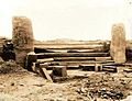
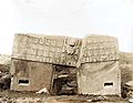
The Pumapunku Platform
The Pumapunku is another man-made platform. It's built on an east-west line, like Akapana. It's a T-shaped mound with terraces, covered in huge stone blocks. It is 167.36 meters wide and 5 meters tall.
A key part of Pumapunku is a large stone terrace called the "Plataforma Lítica". It measures 6.75 by 38.72 meters. This terrace holds the largest stone block found at Tiwanaku. It is estimated to weigh 131 metric tons! The second largest block here weighs about 85 metric tons.
Around Pumapunku, you can see many stones cut with amazing detail. Some people have wondered if aliens helped, because the stonework is so complex. However, many stones are unfinished. They show how the people might have cut them using their own skills.

Kalasasaya and the Sun Gate
The Kalasasaya is a large courtyard, over 300 feet long. It's bordered by a tall gateway. It sits north of Akapana. The famous Gate of the Sun was found inside this courtyard. However, experts now believe this was not its original spot.
Near the courtyard is the Semi-Subterranean Temple. This is a square, sunken courtyard. It's special because it faces north-south, not east-west. Its walls are covered with many different carved stone heads. This suggests the temple was used for different things over time. The largest stone in Kalasasaya weighs about 26.95 metric tons.
Many buildings at Tiwanaku have impressive gateways. The biggest ones are on artificial mounds or in sunken courtyards. Many gateways show images of the Staff God. This image is also on some large pots, showing its importance. The Gate of the Sun has the most of these images.
The Gate of the Sun has unique carvings of animals and other figures. Some believe these symbols show a special calendar system used by the Tiwanaku people. But there is no clear proof for this idea.
The Gate of the Sun and other gateways at Pumapunku are not fully finished. They are missing parts of their frames. These frames usually had holes for clamps to add more pieces. These gateways show how skilled the Tiwanaku stone cutters were. They understood how to plan and measure complex shapes. This suggests they used a system of proportions.
.jpg)
How Tiwanaku Builders Worked
Many ideas explain how Tiwanaku's buildings were made so well. One idea is that they used a standard measurement called a luk’a, which was about 60 centimeters. Another idea is that they used the Pythagorean Ratio. This involves using right triangles with a 5-4-3 ratio to measure all parts of the gateways.
Lastly, some experts believe Tiwanaku had a system for each part of a building. This system changed based on where the part was used. This is seen in similar gateways that range from small to huge. The scaling did not change the overall look. As new parts were added, individual pieces were adjusted to fit perfectly.
Life in Tiwanaku
As the city grew, people started to have special jobs. More artists appeared, working with pottery, jewelry, and cloth. Like the later Inca, the Tiwanaku did not have many markets. Instead, the leaders controlled all the goods. They were expected to give common people what they needed for their jobs. People had jobs like farmers or animal herders. This separation of jobs also meant there were different levels of society.
Some believe that Tiwanaku's leaders lived inside walls surrounded by a moat. This idea is called the "Tiwanaku moat theory." Some think the moat made the area look like a sacred island. Inside the walls were many images about human origins. Only the leaders would see these. Common people might have entered only for special ceremonies. This area was home to the holiest shrines.

Tiwanaku's Spiritual Beliefs
In many Andean cultures, mountains are seen as sacred. The Tiwanaku site is in a valley between two sacred mountains, Pukara and Chuqi Q’awa. In ancient times, ceremonies were held at temples to honor gods and spirits. These places helped unite Andean people through shared beliefs and special journeys.
Tiwanaku became a major center for religious ceremonies. Both common people and leaders took part. For example, some ancient groups offered sacrifices to please gods. At the Akapana temple in Tiwanaku, archaeologists found remains of humans and camelids (like llamas) that were offered.
Experts think the Akapana temple might have also been an observatory. It was built to line up with the peak of Quimsachata. This allowed people to see the Milky Way rotate from the southern sky. Other temples, like Kalasasaya, are placed to give the best views of the sunrise on the Equinox and Solstices. The Tiwanaku people studied the sun, moon, and stars. They used this knowledge in their building designs.
The Center of the Universe
Aymara legends say Tiwanaku is the center of the universe. This is likely because of its important location. The Tiwanaku people knew a lot about their surroundings. They used mountains and their understanding of astronomy to plan their buildings.
The most important natural features for Tiwanaku were the mountains and Lake Titicaca. Today, the lake is 20 kilometers west of Tiwanaku. But in ancient times, it probably reached the city. The lake's location and spiritual meaning made Tiwanaku very important. In the Tiwanaku worldview, Lake Titicaca was the spiritual birthplace of their beliefs.
In Inca stories, Lake Titicaca is where Viracocha was born. Viracocha was believed to create the sun, moon, people, and the universe. In the Kalasasaya temple, a carving on a large stone (the Gate of the Sun) shows a god holding a lightning bolt. Many think this is Viracocha, because the figure wears a sun crown. However, it might also be a god the Aymara call "Tunuupa." Tunuupa is also linked to stories of creation and destruction.
The Aymara people, who may be descendants of the Tiwanaku, have a complex belief system. It's similar to other Andean groups. They believe in three worlds:
- Arajpacha: The upper world, linked to the cosmos and Milky Way, where sky beings live.
- Akapacha: The middle world, where all living things are.
- Manqhaoacha: The lower world, where life is reversed.
Exploring Tiwanaku: Archaeology
.jpg)

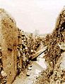
The Tiwanaku site has been damaged over time. People have dug for treasures, and amateur explorers have caused harm. This destruction continued during the Spanish conquest and in later centuries. Stones were also taken for building and railroad construction. Even military training caused damage.
Today, no original buildings stand tall. Only the foundations of public buildings remain, with some poorly rebuilt walls. The stone blocks used in many buildings were made in similar styles. This meant they could be used for different purposes. Over time, some buildings changed their use. This is why different kinds of artifacts are found mixed together today.
Early Studies of Tiwanaku
Detailed study of Tiwanaku began in the mid-1800s. In the 1860s, Ephraim George Squier visited the ruins. He later published maps and drawings. A German geologist, Alphons Stübel, spent nine days there in 1876. He made a map based on careful measurements. He also drew sketches and made copies of carvings.
In 1892, a book with many photos was published by Georg von Grumbkow. With notes from archaeologist Max Uhle, this was the first deep scientific look at the ruins. Von Grumbkow had visited Tiwanaku earlier, in 1876-1877. He took pictures during an expedition, and these early photos still exist.
- Pictures of archaeological excavations in 1903
-
Stairs of Kalasasaya (1903)
-
Semi-Subterranean Temple (1903)
-
Gate of the Sun (1903)
-
Gate of the Sun, Rear View (1903)


_1903-1904.jpg)

Modern Excavation and Restoration

In the 1960s, the Bolivian government tried to restore parts of the site. The walls of the Kalasasaya are mostly rebuilt. The original Kalasasaya stones might have looked more like "Stonehenge," standing straight and spaced out. This rebuilding wasn't always based on enough research. For example, a new wall was built around Kalasasaya. The new stonework isn't as good as the original Tiwanaku work. Also, the Gate of the Sun, now in Kalasasaya, is thought to have been moved from its first spot.
From 1978 to the 1990s, Alan Kolata and Oswaldo Rivera led proper archaeological digs. They rediscovered ancient farming systems called suka kollus. They also accurately dated the civilization's growth. They found evidence that a drought caused Tiwanaku's collapse.
Some archaeologists, like Paul Goldstein, believe the Tiwanaku empire reached beyond the high plains. They think it extended into the Moquegua Valley in Peru. Digs at Omo settlements show similar buildings to Tiwanaku. These include a temple and terraced mound. Evidence of similar head shaping in burials also supports this idea.

Today, Tiwanaku is a UNESCO World Heritage Site. The Bolivian government manages it.
Recently, the Department of Archaeology of Bolivia has been digging at the Akapana mound. The Pumapunku-Akapana Archaeological Project, run by the University of Pennsylvania, has also been working nearby. They use Ground Penetrating Radar to survey the area.
In 2009, restoration work on Akapana was stopped. UNESCO complained because the pyramid was being covered with adobe. Researchers had not confirmed this was the right way to restore it.
In 2013, marine archaeologists explored Lake Titicaca's Khoa reef. They found an ancient ceremonial site underwater. They brought up items like lapis lazuli and ceramic figures, incense burners, and a medallion. These items show how rich the Tiwanaku ceremonies were.
In 2016, a drone was used to create a map of the site. This map showed "a set of structures never seen before." These structures covered over 411 hectares. They included a stone temple and about one hundred round or square buildings. These were possibly homes.
Seeing Tiwanaku from Above
Between 2005 and 2007, UNESCO used different aerial methods to map the site. They used Lidar, aerial photography, drones, and laser scanning. This research created detailed maps. These maps show the main buildings and other structures in the Mollo Kuntu area. Over 300 million data points were collected. This has helped redefine major structures, like Pumapunku, that haven't been fully dug up yet.
Tiwanaku's Impact on the World
Tiwanaku has many beautiful sculptures and buildings. They inspired many other cultures. Since Tiwanaku was one of the earliest known South American civilizations, it influenced later groups like the Inca. Tiwanaku's unique farming system, called flooded raised fields, was a first of its kind. It was later used by many other civilizations.
Today, the city's remains are still important to the Aymara people, who are native to Bolivia. In 2006, Bolivia's 65th president, Evo Morales, became the first indigenous president. He held his inauguration ceremony at the Tiwanaku site.
Important Researchers of Tiwanaku
- Alan Kolata from the University of Chicago studied Tiwanaku in the late 1900s. He wrote about the city's structure and culture in his book The Tiwanaku. Later, he published Valley of The Spirits, which covered Tiwanaku's astrology and myths.
- John Wayne Janusek from Vanderbilt University also spent time at Tiwanaku in the late 1900s. He recorded findings from the digs. In 2008, he published Ancient Tiwanaku. This book described his findings on Tiwanaku's buildings, farming, and daily life.
- Jean-Pierre Protzen was an architecture professor at the University of California at Berkeley. He spent much of his life studying Tiwanaku's architecture. In 2013, he published The Stones of Tiahuanaco. This book gives great descriptions of the buildings and stonework. His work has been very important in creating possible ideas of what many structures, especially Pumapunku, looked like.
See also
 In Spanish: Tiahuanaco para niños
