Iruya facts for kids
Quick facts for kids
Iruya
|
|
|---|---|

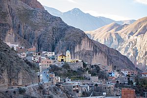
View of Iruya
|
|
| Founded | 1753 |
| Elevation | 2,780 m (9,120 ft) |
| Population
(2010)
|
|
| • Total | 1,523 |
| • Density | 1.66/km2 (4.3/sq mi) |
Iruya is a small, charming town located in the northwestern part of Argentina. About 1,070 people live here. It is found in the Salta Province and is the main town of the Iruya Department.
Exploring Iruya
Iruya is nestled high up in the mountains, about 2,780 meters (9,120 feet) above sea level. It's part of a high plateau region called the altiplano, right by the Iruya River. Imagine a town built right into the side of a mountain!
Getting to Iruya is an adventure. It's over 300 kilometers (186 miles) from Salta, the capital city of the province. There isn't a direct road from Salta Province itself. You have to travel through the neighboring Jujuy province. Part of this road, about 50 kilometers (31 miles), is unpaved, making the journey quite unique.
Even with the tricky roads, many tourists love to visit Iruya. They come for the amazing mountain views, the special way the town is built, and the friendly people who live there.
Close to Iruya, you can find other small villages. San Isidro is about 8 kilometers (5 miles) north. San Juan is 7 kilometers (4 miles) north. And Pueblo Viejo is 6 kilometers (4 miles) south.
The name "Iruya" comes from the Quechua language. It means "abundance of straw," which probably refers to the plants growing in the area.
A Glimpse into Iruya's Past
Iruya was officially started in 1753. However, people began living here much earlier, about 100 years before that. The first people were mostly aboriginals, which means they were the original inhabitants of the land.
Their history goes back to the Ocloyas. These people were part of a larger group called the Kolla. The Kolla people came from a region known as the Kollasuyo, which was one of the four main areas of the ancient Inca empire.
The church in Iruya is very old. It was built way back in 1690, showing how long people have lived and worshipped in this special place.
Iruya's Weather
Iruya has a unique mountain climate. The temperatures are generally mild, but it can get quite cold, especially at night and in the winter months (June, July, August). The warmest months are usually from October to March.
The town doesn't get a lot of rain overall. Most of the rain falls during the summer months, from January to March. The rest of the year, especially from May to September, is very dry. This dry weather is typical for high-altitude regions like the altiplano.
See also
 In Spanish: Iruya para niños
 | Selma Burke |
 | Pauline Powell Burns |
 | Frederick J. Brown |
 | Robert Blackburn |


