
Yungas facts for kids
Quick facts for kids
Yungas
|
|
|---|---|
|
Natural region
|
|

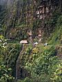
Yungas Road in Bolivia
|
|

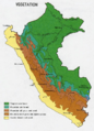
Vegetation of Peru. Mountain rainforest in blue-green.
|
|
| Country | Peru and Bolivia |
The Yungas is a special natural area found along the eastern side of the Andes Mountains. It stretches through Peru, Bolivia, and into northern Argentina. The name "Yungas" comes from words in the Aymara and Quechua languages. These words mean "warm" or "temperate area" on the slopes of the Andes.
This region acts like a bridge between the high, cold Andes mountains and the warmer forests to the east. The climate in the Yungas is usually rainy, humid, and warm. It is part of the Neotropical realm, which is a large area covering much of Central and South America.
Contents
What the Yungas Look Like
The forests in the Yungas are incredibly diverse. They include everything from moist forests in lower areas to evergreen mountain forests and even cloud forests. Cloud forests are special because they are often covered in mist and clouds.
The land here is very rugged, with many valleys, mountain paths, and streams. This varied landscape helps create many different habitats. Because of this, the Yungas is home to a huge variety of plants and animals. Many species found here live nowhere else in the world. Some of these evergreen forests might even be the last ones left from the Ice Ages long ago.
Yungas Ecoregions
The World Wide Fund for Nature (WWF) has identified three main Yungas ecoregions. An ecoregion is a large area of land or water that contains a distinct group of natural communities and species.
- The Peruvian Yungas is the most northern part. It is found entirely within Peru and covers almost the whole length of the country.
- The Bolivian Yungas is located to the south, completely within Bolivia. The Cordillera Apolobamba mountain range separates the Peruvian and Bolivian Yungas.
- The Southern Andean Yungas starts in southern Bolivia and continues into northern Argentina. This area is a humid forest located between the drier Gran Chaco region to the east and the dry, high Puna region to the west.
These Yungas areas are like transition zones. They connect the high Andes mountains with the eastern forests. The forests are very diverse, from moist lowland areas to evergreen mountain and cloud forests. The land is rough and varied, which helps create a rich mix of plants and animals. Many of these forests stay green all year.
Climate of the Yungas
The average temperature in the Yungas is about 72 °F (22 °C). However, the climate can change a lot depending on how high up you are. It ranges from a humid tropical climate in lower areas to very cold conditions in the Andes mountains over 10,000 ft (3,000 m) high.
Peruvian Yungas
In Peru, people sometimes use the words "Yunga" and "Yungas" differently.
- Yunga (singular) refers to a natural region on both sides of the Peruvian Andes. The western side, closer to the coast, is called Sea Yunga. The eastern side, leading into the jungle, is called Fluvial Yunga. Both reach up to 2,300 m in height.
- Yungas (plural) refers to the larger ecoregion of rainforest and mountain forest. This area is found between 1,000 m and 3,500 m high. It is mostly on the eastern side of the Andes. This "Yungas" concept is similar to how the Bolivian Yungas is described. This region in Peru is known for having the most unique biodiversity.
Sadly, a lot of forest has been lost in the Peruvian Yungas. This loss has increased a lot since the early 2000s.
Sea Yunga
Sea Yunga, also known as Maritime Yunga, is found on the western side of the Andes. It is located between 500 and 2,300 meters above sea level. This area has a subtropical desert climate. This means it gets very little rain, especially along the central and southern coast. The average daytime temperature year-round is about 70 °F (21 °C).
In some hilly areas near the Pacific Ocean, up to 1,000 m high, there are special mist-fed ecosystems called Lomas. These areas get their water from fog that rolls in from the ocean.
Plants of Sea Yunga
The plants in the central Sea Yungas region include lucuma and cherimoya trees. You can also find casuarin trees here.
As you go north in the Sea Yunga, the climate becomes more subtropical. Daytime temperatures average between 70 °F (21 °C) and 77 °F (25 °C).
Animals of Sea Yunga
The animals in the northern Sea Yunga are different from the rest of the coast. You might find boa snakes and other large reptiles. A very special bird, the white-winged guan, lives only in this Peruvian ecoregion. Common trees in this northern area include the faique, the sapote, the zapayal, and the barrigon. These are thorny trees typical of dry tropical forests.
Fluvial Yunga
Fluvial Yunga is located on the eastern side of Peru. It is found at altitudes between 1,000 m and 2,300 m. This area has a subtropical climate with plenty of rain during certain seasons. The average temperature here ranges from 68 °F (20 °C) to 77 °F (25 °C), depending on the altitude.
At 1,000 m above sea level, the climate is about 4.9 °C cooler than the lowland tropical rainforest. The subtropical cloud forest (Fluvial Yunga) follows the tropical rainforest. At 2,300 m, the climate changes from subtropical to temperate. This temperate zone is called Quechua. The Tree line, where trees stop growing due to cold, ends at about 3,500 m. The region between the tree line and 4,000 m is called Suni or Jalca. Suni is a dry and cold area with many valleys formed by glaciers. Even with the harsh weather, some crops like quinoa, maca, qañiwa, broad beans, and ulluku are grown here.
Plants and Animals of Fluvial Yunga
The plants in the Fluvial Yunga are mainly subtropical cloud forest species. These include the Peruvian pepper tree, Furcraea, white cabuya (Furcraea andina), pitahaya, and the Peruvian torch cactus (Echinopsis peruviana). The coca leaf plant also grows here, as well as the "cat's claw" plant (Uncaria tomentosa). This warm and refreshing region is famous for its many orchid forests and beautiful valleys. The animals in the Fluvial Yunga include the long-tailed mockingbird, also known as chaucato.
Overview of Andean Regions
Here's a simple way to see how the different regions of the Andes change as you go up in height, from the west side (towards the Pacific Ocean) to the east side (towards the Amazon rainforest):
| Westside | Eastside |
|---|---|
| Chala, dry coast | Lowland tropical rainforest or Selva baja |
| Maritime Yunga | Highland tropical rainforest or Selva alta |
| Maritime Yunga | Subtropical cloud forest or Fluvial Yunga |
| Quechua – Montane valleys | Quechua – Montane valleys |
| Tree line | Tree line – about 3,500 m |
| Suni, scrubs and agriculture | Suni, scrubs and agriculture |
Higher up on the mountains, you find:
- Mountain passes – around 4,100 m
- Puna grassland (with closed or scattered plants)
- Andean-alpine desert
- Snow line – where snow stays all year, about 5,000 m
- Janca – areas of rocks, snow, and ice
- The very top of the mountain, the Peak
Bolivian Yungas
How People Use the Land
In the early 1900s, the Bolivian Yungas was important for producing rubber and quinine (a medicine). Today, important crops grown here include coffee, citrus fruits, and coca leaves. People also grow native plants like the canistel (eggfruit tree), the lúcuma tree, the cherimoya, the guava, and the avocado.
Many people from the Afro Bolivian community live in this region.
The Yungas is also home to a very famous and dangerous road, often called the "camino de la muerte," which means "Highway of Death." It is officially known as the Yungas Road.
Because the land is so mountainous, some clever coca farmers have built networks of zip lines. These zip lines help them travel quickly from one mountain peak to another. They also use them to transport their harvests. Locals sometimes call these farmers "flying men" or "bird men" because of how they use the zip lines.
Argentine Yungas
Images for kids
-
Yungas Road in Bolivia
-
Vegetation of Peru. Mountain rainforest in blue-green.
See also
 In Spanish: Yungas para niños
- Tropical Andes
- Geography of Bolivia
- Yungas Road, North road: 3,600 to 4,650 m (La Cumbre pass, Bolivia), then to 330 m in 61–69 km
- Peruvian Amazon
- Natural regions of Peru
- Climate zones by altitude
- Altitudinal zonation
Other sources
- Endemic Bird Areas for the Bolivian and Peruvian upper yungas and the Bolivian and Peruvian lower yungas. BirdLife International, 2003. BirdLife's online World Bird Database. Version 2.0. Cambridge, UK.
