Tartagal, Salta facts for kids
Quick facts for kids
Tartagal
|
||
|---|---|---|
 |
||
|
||
| Country | ||
| Province | ||
| Department | San Martín | |
| Founded | 1924 | |
| Area | ||
| • Total | 3,015 km2 (1,164 sq mi) | |
| Elevation | 490 m (1,610 ft) | |
| Population
(2010 census)
|
||
| • Total | 63,196 | |
| • Density | 20.961/km2 (54.288/sq mi) | |
| Time zone | UTC-3 (ART) | |
| CPA base |
A4560
|
|
| Dialing code | +54 3875 | |
| Climate | Cwa | |
| Website | Tartagal website | |
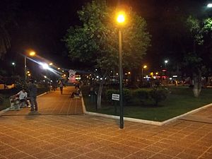
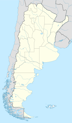
Tartagal is a tropical city in northern Argentina. It is located in the Salta province. The city is in the northeast part of the province, and it is the capital of the General José de San Martín Department.
Tartagal is nestled in the Yungas jungle, with mountains to the west and plains to the east. This special location means it has many different kinds of plants and animals. Eight different native communities live here. The city is also known for its many large trees like mangoes and lapachos. It's one of the few places where the green macaw still lives in the wild.
Tartagal is the third most important city in Salta province, after Orán. Its economy is strong because of oil and gas. It also has important forestry (wood) and farming activities.
The city is about 365 kilometers from Salta, the provincial capital. It's also close to the borders of Bolivia (57 km away) and Paraguay (103 km away). Tartagal is connected to the rest of Argentina by National Route 34 and National Route 86. It also has an airport, General Mosconi airport, but it doesn't have regular passenger flights right now.
Tartagal is a center for learning. It has branches of the National University of Salta and the Catholic University of Salta. There are also learning centers from other universities like Siglo 21 and Blas Pascal.
Contents
History of Tartagal
The name Tartagal comes from the tártago plant, which is a type of spurge. The area was first mentioned with this name in official papers in 1853. At that time, the area was part of Bolivia.
The city of Tartagal was officially founded on June 13, 1924. It became a city on September 22, 1949. The Argentine Army has a special unit, the 17th Jungle Cazadores Company, based in Tartagal.
Oil Discovery and Its Impact
In the early 1900s, large amounts of oil were found in Tartagal. This led to the creation of the state-owned oil company, Yacimientos Petrolíferos Fiscales (YPF), in 1922. YPF was very important for the city. It provided jobs, social security, and education for workers' children. This helped many families and boosted the local economy.
However, in 1992, YPF was sold to a private company. This meant that many workers lost their jobs. This caused social problems in Tartagal and other oil-producing areas.
Rocket Launches and Natural Disasters
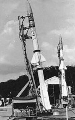
On November 12, 1966, scientists launched several sounding rockets from Tartagal. These rockets were used to study a solar eclipse.
On February 9, 2009, heavy rains caused the Tartagal River to overflow. This flooded much of the city and sadly caused 11 deaths.
People and Cultures in Tartagal
Tartagal is a city with many different cultures. Seven native groups live here:
- Wichís
- Chiriguanos
- Chanés
- Quechuas
- Chorotes
- Chulupíes
- Aymaras
Because Tartagal is so close to Bolivia, many people living here have Bolivian family roots. The city also has people from other countries, including:
- People from the Levant (like Syria and Lebanon)
- Greeks (including people from Cyprus)
- Irish people
- Paraguayans
- Spaniards
Tartagal's Population
According to the 2010 census, Tartagal had 64,530 people living there. This makes it the third most populated city in its province. Only the provincial capital and San Ramón de la Nueva Orán have more people.
Climate in Tartagal
Tartagal has a humid subtropical climate. This means it has hot, wet summers and mild, drier winters.
| Climate data for Tartagal, Salta (1991–2020, extremes 1961–present) | |||||||||||||
|---|---|---|---|---|---|---|---|---|---|---|---|---|---|
| Month | Jan | Feb | Mar | Apr | May | Jun | Jul | Aug | Sep | Oct | Nov | Dec | Year |
| Record high °C (°F) | 43.6 (110.5) |
42.6 (108.7) |
39.6 (103.3) |
37.5 (99.5) |
36.8 (98.2) |
34.7 (94.5) |
37.7 (99.9) |
41.0 (105.8) |
43.0 (109.4) |
44.3 (111.7) |
44.8 (112.6) |
44.2 (111.6) |
44.8 (112.6) |
| Mean daily maximum °C (°F) | 32.3 (90.1) |
31.0 (87.8) |
29.0 (84.2) |
26.1 (79.0) |
23.0 (73.4) |
21.5 (70.7) |
22.1 (71.8) |
26.0 (78.8) |
28.9 (84.0) |
31.4 (88.5) |
31.9 (89.4) |
32.5 (90.5) |
28.0 (82.4) |
| Daily mean °C (°F) | 26.0 (78.8) |
24.9 (76.8) |
23.5 (74.3) |
20.9 (69.6) |
17.7 (63.9) |
15.4 (59.7) |
14.8 (58.6) |
17.9 (64.2) |
21.1 (70.0) |
24.4 (75.9) |
25.2 (77.4) |
26.0 (78.8) |
21.5 (70.7) |
| Mean daily minimum °C (°F) | 20.8 (69.4) |
20.3 (68.5) |
19.5 (67.1) |
17.1 (62.8) |
13.6 (56.5) |
11.1 (52.0) |
9.3 (48.7) |
10.9 (51.6) |
14.1 (57.4) |
18.0 (64.4) |
19.1 (66.4) |
20.4 (68.7) |
16.2 (61.2) |
| Record low °C (°F) | 11.3 (52.3) |
11.2 (52.2) |
8.0 (46.4) |
4.5 (40.1) |
2.0 (35.6) |
−2.6 (27.3) |
−5.9 (21.4) |
−5.4 (22.3) |
0.4 (32.7) |
2.4 (36.3) |
7.8 (46.0) |
10.2 (50.4) |
−5.9 (21.4) |
| Average precipitation mm (inches) | 193.2 (7.61) |
197.8 (7.79) |
164.5 (6.48) |
59.3 (2.33) |
24.4 (0.96) |
8.7 (0.34) |
4.0 (0.16) |
3.8 (0.15) |
17.9 (0.70) |
46.3 (1.82) |
112.2 (4.42) |
165.0 (6.50) |
997.1 (39.26) |
| Average precipitation days (≥ 0.1 mm) | 11.1 | 11.2 | 12.0 | 9.5 | 6.8 | 3.8 | 2.3 | 1.2 | 2.3 | 5.7 | 8.7 | 10.8 | 85.4 |
| Average relative humidity (%) | 73.8 | 78.4 | 82.0 | 82.4 | 81.8 | 78.9 | 69.5 | 56.1 | 50.6 | 57.0 | 63.5 | 69.8 | 70.3 |
| Mean monthly sunshine hours | 201.5 | 169.5 | 148.8 | 126.0 | 114.7 | 114.0 | 161.2 | 198.4 | 168.0 | 164.3 | 177.0 | 182.9 | 1,926.3 |
| Mean daily sunshine hours | 6.5 | 6.0 | 4.8 | 4.2 | 3.7 | 3.8 | 5.2 | 6.4 | 5.6 | 5.3 | 5.9 | 5.9 | 5.3 |
| Source: Servicio Meteorológico Nacional | |||||||||||||
See also
 In Spanish: Tartagal para niños
 | Janet Taylor Pickett |
 | Synthia Saint James |
 | Howardena Pindell |
 | Faith Ringgold |


