Quilotoa facts for kids
Quick facts for kids Quilotoa |
|
|---|---|

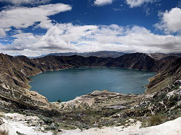
Panorama of the lake-filled Quilotoa caldera.
|
|
| Highest point | |
| Elevation | 3,914 m (12,841 ft) |
| Prominence | 302 m (991 ft) |
| Listing | List of volcanoes in Ecuador |
| Geography | |
| Location | Pujilí Canton, Cotopaxi Province, Ecuador |
| Parent range | Andes |
| Geology | |
| Age of rock | approx. 40,000 years |
| Mountain type | Caldera |
| Last eruption | 1280 |
Quilotoa (pronounced kee-loh-TOH-ah) is a stunning water-filled lake located inside a volcano in the Andes mountains of Ecuador. It's the westernmost volcano in the Ecuadorian Andes. The lake sits within a large bowl-shaped area called a caldera, which is about 3 kilometers (1.9 miles) wide.
This caldera was formed when the volcano collapsed after a huge eruption about 800 years ago. This powerful eruption, known as a Plinian eruption, sent fast-moving clouds of hot gas and ash (called pyroclastic flows) and mudslides (called lahars) all the way to the Pacific Ocean. It also spread volcanic ash across the northern Andes. The lake inside the caldera is now about 250 meters (820 feet) deep. It has a unique greenish color because of the dissolved minerals in the water. You can even find small vents releasing gas (called fumaroles) on the lake floor and hot springs on the volcano's eastern side.
Contents
About Quilotoa Volcano
Quilotoa is a volcano that has been active for a very long time. It is estimated to be around 40,000 years old. The last major eruption happened in the year 1280. Before this, the volcano had been quiet for about 14,000 years.
How the Lake Formed
The huge eruption in 1280 caused the top of the volcano to collapse, creating the large bowl-shaped caldera. Over time, this caldera filled with water, forming the beautiful lake we see today. Scientists believe a lake was already present during some parts of the eruption, as there is evidence of water interacting with the magma.
The Lake's Features
The surface of Quilotoa Lake is located about 3,500 meters (11,480 feet) above sea level. The lake holds a massive amount of water, about 0.35 cubic kilometers. Local people have noticed that the lake's water level has been slowly going down over the last 10 years. You can also see white deposits, called travertine, along the shore. These deposits show where the water level used to be, sometimes as much as 10 meters (33 feet) higher than it was in the year 2000.
Visiting Quilotoa
Quilotoa is becoming a very popular place for tourists. Many people visit to see the stunning lake and enjoy the surrounding nature.
Getting There
The small town of Quilotoa is often reached by bus from Latacunga, which is a common starting point. Another way is to take a hired truck or bus from the town of Zumbahua, which is about 17 kilometers (11 miles) to the south. When you arrive, visitors pay a small fee to enter the area.
Activities at the Crater
There are several simple places to stay, called hostels, near Quilotoa. These hostels often offer services like renting mules or providing guides for your adventures.
One popular activity is hiking around the rim of the caldera. This hike is about 10 kilometers (6.2 miles) long and usually takes four to five hours. The rim of the caldera is not flat; it has high points reaching up to 3,915 meters (12,844 feet) in some areas. The trail can be sandy and steep in places, which can be quite tiring, especially if there is fog.
You can also hike down from the viewpoint to the lake itself. This takes about half an hour to go down. The hike back up is much harder, taking one to two hours because it's a steep climb of about 280 meters (919 feet). There is very basic lodging available at the bottom of the crater. Camping is allowed inside the crater, but there is no drinking water available, except for small bottles sold at the hostel.
The Quilotoa Loop
The village of Quilotoa and its famous crater are also a key part of the "Quilotoa Loop." This is a popular multi-day hiking route that connects several small villages. It's a great way to explore the local culture and beautiful landscapes.
See also
 In Spanish: Quilotoa para niños
- Volcanic crater lake
 | William Lucy |
 | Charles Hayes |
 | Cleveland Robinson |

