
Tronador facts for kids
Quick facts for kids Tronador |
|
|---|---|

View of Tronador mountain from Mascardi Lake, Argentina
|
|
| Highest point | |
| Elevation | 3,491 m (11,453 ft) |
| Prominence | 2,642 m (8,668 ft) |
| Listing | Region high point Province high point Ultra |
| Naming | |
| English translation | thunderer |
| Geography | |

Tronador
Location in Argentina
|
|
| Location | Río Negro, Argentina Los Lagos, Chile |
| Parent range | Andes |
| Geology | |
| Mountain type | Stratovolcano |
| Volcanic arc/belt | South Volcanic Zone |
| Last eruption | Unknown |
| Climbing | |
| First ascent | 1934 by Hermann Claussen |
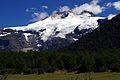
Tronador (which means "Thunderer" in Spanish) is an extinct stratovolcano (a cone-shaped volcano built up by many layers of hardened lava and ash) located in the Andes mountains. It sits right on the border between Argentina and Chile, close to the Argentine city of Bariloche. Locals named it 'Thunderer' because of the loud sounds made by falling seracs (large blocks of ice) from its glaciers.
Standing at about 3,470 meters (11,380 feet) tall, Tronador is much higher than other mountains nearby. This makes it a popular place for mountain climbing. It is found within two national parks: Nahuel Huapi in Argentina and Vicente Pérez Rosales in Chile. Tronador has eight glaciers, but they are shrinking because the air higher up is getting warmer.
Contents
What is Tronador Mountain Like?
Tronador is located in the Wet Andes, an area that gets a lot of snow and rain. This wet, cool climate has helped many glaciers grow there. Most of the rain and snow comes from weather systems moving in from the Pacific Ocean.
Tronador is part of a beautiful mountain landscape. This area includes fjords (long, narrow inlets of the sea), glacial lakes, and U-shaped valleys. This unique landscape was formed during the Quaternary glaciations, which were periods when huge ice sheets covered the entire region.
How Tronador Formed
The volcano grew during the glacial (cold) and interglacial (warm) periods of the Pleistocene era. However, it became mostly inactive about 300,000 years ago. This happened because the active part of the Southern Volcanic Zone, where it belongs, shifted. Since then, glaciers and other natural forces have shaped the mountain. No new lava or tephra (volcanic ash and rock) has come out. Tronador is mostly made of basalt rock. Its activity has decreased as other volcanoes like Osorno and Calbuco have become more active further west.
Tronador's Glaciers


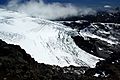
Tronador is famous for the many glaciers that cover its sides. There are eight known glaciers: Alerce, Ventisquero Negro, Casa Pangue, Castaño Overa, Río Blanco, Frías, Peulla, and Manso.
Like most glaciers in the southern Andes, Tronador's glaciers have been shrinking over the last few decades. For example, the Casa Pangue glacier on the northwest side of Tronador became thinner between 1961 and 1998. Its shrinking sped up between 1981 and 1998, losing about 52 meters (170 feet) per year. This shrinking is happening because there is less rain and snow, and the air higher up is getting warmer.
The Alerce Glacier, on the Argentinian side, can be visited from Refugio Otto Meiling. This is a mountain hut located between the Alerce and Castaño Overa Glaciers. The Castaño Overa Glacier, also in Argentina, is smaller and easier to reach by hiking from Pampa Linda. Guided tours allow visitors to walk across Castaño Overa or climb to Tronador's peak.
Ventisquero Negro means "black snowdrift" in Spanish. This unusual glacier is at the base of Tronador in Nahuel Huapi National Park. Its dark brown color comes from dirt and sediment it picks up. This dirt comes from the Río Manso Glacier, which feeds Ventisquero Negro from higher up the mountain. Brown icebergs break off from this glacier and float in a small lake until they melt.
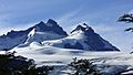
Peaks of Tronador
Tronador has several named peaks and ridges. The highest peaks include Anon or Internacional (3484m), Argentino (3187m), Chileno (3262m), and Torre Ilse (2585m). Some named ridges are Filo Sur (3054m), Filo Blanco (3146m), Filo La Vieja (2715m), and Filo Lamotte (2340m).
Climbing and Visiting Tronador

Tronador was first climbed by Hermann Claussen by himself on January 29, 1934. He had tried to reach the top several times before.
A mountain hut called Refugio Otto Meiling is a popular spot for day hikes on the mountain. It is named after a German mountaineer who climbed Tronador many times and guided people around it for years. The hut is about 1,200 meters (3,900 feet) higher than Pampa Linda, which is at the base of the mountain.
Most summers, the Internacional or Anon peaks (the highest of Tronador's three peaks) can be climbed. However, a very hot summer in January and February 2008 caused dangerous rockfalls. The Argentine side of the mountain might become harder to access in the future. This is because warmer weather in the area is making the glaciers less stable.
See also
 In Spanish: Cerro Tronador para niños
- Cerro Volcánico
- Bariloche
Gallery
-
Seen from Pampa Linda.
-
-
Alerce Glacier, one of Tronador's 7 glaciers.


