
El Alto facts for kids
Quick facts for kids
El Alto
Patamarka
|
||
|---|---|---|
|
City and municipality
|
||
    El Alto City
|
||
|
||
| Motto(s):
Desde la cumbre más alta del mundo levántase la ciudad donde jamás se pondrá el sol de nuestra raza (From the highest summit in the world rises the city where the sun of our race will never set)
|
||

El Alto
Location in Bolivia

El Alto
Location in South America
|
||
| Country | ||
| Department | ||
| Province | Pedro Domingo Murillo | |
| Municipality | El Alto Municipality | |
| Area | ||
| • City and municipality | 363 km2 (140 sq mi) | |
| Elevation | 4,150 m (13,620 ft) | |
| Population
(2020 Census)
|
||
| • Rank | 2nd | |
| • Urban | 943,000 | |
| • Metro | 2,200,000 | |
| Time zone | UTC−4 (BOT) | |
| Website | Official website: http://www.elalto.gob.bo/ | |

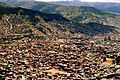
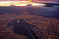
El Alto means "The Heights" in Spanish. It's the second-largest city in Bolivia. It sits right next to La Paz on the high plains called the Altiplano. El Alto is one of Bolivia's fastest-growing cities. In 2020, about 943,558 people lived there. It is also the highest major city in the world. Its average height is about 4,000 meters (13,123 feet) above sea level.
The area around El Alto and La Paz is home to about 2.2 million people. This makes it the most populated urban area in Bolivia. The city is growing quickly. It faces challenges with its buildings and services, especially in newer areas. A cool cable car system now connects El Alto to central La Paz. This has made travel much easier. A unique building style called Neo-Andean architecture has also grown here. It gives the city a special look as it becomes more modern.
Contents
History of El Alto
The flat, cold area above La Paz was empty for a long time. But in 1903, new railways reached the edge of the canyon. This is where the trains to La Paz stopped. Workers built homes and depots there, starting a small town. In 1925, an airfield was built for the new air force. This brought more people to live in the area. El Alto's first elementary school opened in 1939.
The town grew a lot in the 1950s. This happened when it got connected to La Paz's water supply. Before that, water had to be brought in by trucks. Also, land in the canyon became very expensive. In March 1985, El Alto became a separate area from La Paz. This day is now celebrated as the city's "founding day." In 1987, El Alto officially became a city. In 1994, it became the main city for the Roman Catholic Diocese of El Alto.
City Districts
El Alto's local government has divided the city into 14 different districts.
People and Growth
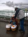
El Alto used to be known as a place where people lived and worked in La Paz. But now, more businesses and factories are growing here. This growth has led to worries about water pollution. Businesses like leather tanneries and slaughterhouses can pollute the water. This affects the city and places downstream. Because the population is growing so fast, the city works hard to provide clean water and sewer services. This is especially true for the new areas of the city.
Geography and Climate

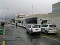
El Alto International Airport is located in the city. El Alto is one of the highest major cities in the world. It sits up to 4,300 meters (13,615 feet) above sea level. The climate is cold. The warmest average high temperature is about 17°C (63°F) in November. El Alto is one of Bolivia's fastest-growing cities. Many people move here from rural areas of Bolivia. This started after a land reform in 1952 and has increased recently. Some people say they moved because it was hard to grow crops in the countryside.
El Alto's Weather
El Alto has a rare type of cold-summer subtropical highland climate. This means temperatures are usually cool during the day. Nights are crisp all year round. Snow can fall at any time of the year.
The city's water supply has been affected by dry weather. This is because glaciers are shrinking. In 2016, the three main dams that supply water to El Alto were almost empty. This was due to a lack of water from melting glaciers.
| Climate data for El Alto, Bolivia (El Alto International Airport, elevation 4,058 m) | |||||||||||||
|---|---|---|---|---|---|---|---|---|---|---|---|---|---|
| Month | Jan | Feb | Mar | Apr | May | Jun | Jul | Aug | Sep | Oct | Nov | Dec | Year |
| Record high °C (°F) | 25.4 (77.7) |
22.8 (73.0) |
25.1 (77.2) |
22.9 (73.2) |
24.0 (75.2) |
20.0 (68.0) |
23.0 (73.4) |
21.0 (69.8) |
23.0 (73.4) |
23.0 (73.4) |
24.2 (75.6) |
22.0 (71.6) |
25.4 (77.7) |
| Mean daily maximum °C (°F) | 14.3 (57.7) |
14.3 (57.7) |
14.2 (57.6) |
14.4 (57.9) |
14.4 (57.9) |
14.0 (57.2) |
13.5 (56.3) |
13.7 (56.7) |
15.3 (59.5) |
15.3 (59.5) |
17.0 (62.6) |
15.7 (60.3) |
15.0 (59.0) |
| Daily mean °C (°F) | 9.3 (48.7) |
9.0 (48.2) |
8.9 (48.0) |
8.8 (47.8) |
8.2 (46.8) |
7.3 (45.1) |
6.8 (44.2) |
8.2 (46.8) |
8.7 (47.7) |
10.0 (50.0) |
10.5 (50.9) |
9.7 (49.5) |
8.8 (47.8) |
| Mean daily minimum °C (°F) | 4.4 (39.9) |
4.4 (39.9) |
3.6 (38.5) |
1.0 (33.8) |
−1.9 (28.6) |
−4.3 (24.3) |
−4.4 (24.1) |
−3 (27) |
−1.0 (30.2) |
1.5 (34.7) |
2.1 (35.8) |
3.6 (38.5) |
0.5 (32.9) |
| Record low °C (°F) | −3.3 (26.1) |
−3.3 (26.1) |
−2.7 (27.1) |
−4.7 (23.5) |
−10.3 (13.5) |
−12.4 (9.7) |
−11.9 (10.6) |
−10 (14) |
−10 (14) |
−5.4 (22.3) |
−5 (23) |
−2.8 (27.0) |
−12.4 (9.7) |
| Average precipitation mm (inches) | 133.7 (5.26) |
104.7 (4.12) |
71.7 (2.82) |
31.7 (1.25) |
14.3 (0.56) |
5.1 (0.20) |
7.1 (0.28) |
15.2 (0.60) |
35.5 (1.40) |
38.1 (1.50) |
50.5 (1.99) |
94.9 (3.74) |
602.5 (23.72) |
| Average precipitation days (≥ 0.1 mm) | 20.7 | 15.8 | 14.2 | 9.8 | 3.6 | 2.8 | 2.8 | 5.1 | 8.2 | 10.4 | 11.5 | 15.5 | 120.3 |
| Average snowy days | 0.07 | 0.0 | 0.0 | 0.03 | 0.0 | 0.03 | 0.13 | 0.67 | 0.37 | 0.17 | 0.17 | 0.03 | 1.67 |
| Average relative humidity (%) | 66 | 72 | 67 | 59 | 48 | 42 | 43 | 42 | 48 | 49 | 51 | 60 | 54 |
| Source 1: Deutscher Wetterdienst, Servicio Nacional de Meteorología e Hidrología de Bolivia (snowy days 1981–2010) | |||||||||||||
| Source 2: Meteo Climat (extremes 1942–present) | |||||||||||||
Things to See and Do
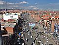
The Museo de Arte Antonio Paredes Candia is an art museum that opened in 2002. El Alto is famous for its Neo-Andean architecture. These unique buildings have been built since the mid-2000s. The city also has a very large open-air market.
City Government
El Alto is a municipality within the Murillo province. The city's government has two main parts:
- The executive branch is led by the mayor. The mayor is chosen by the people in an election every five years.
- The legislative branch is the municipal council. This council has 11 members. They choose a president, vice president, and secretary from their group.
The current mayor is Monica Eva Copa. She won against another candidate in March 2021. The city government works to provide public services and safety. It also works with local community groups, like the successful Fejuve movement.
Getting Around
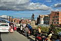
El Alto is connected to La Paz by three lines of the Mi Teleférico system. This is a network of cable cars. The city also has El Alto International Airport. This airport connects El Alto to other cities in Bolivia and around the world.
Images for kids
-
El Alto, Bolivia
-

University in El Alto (Universidad Franz Tamayo)
-
El Alto Airport
-
El Alto, La Paz Department
-
El Alto, Bolivia
-
Winter morning in El Alto
-
El Alto, Bolivia


.jpg)
_on_the_right_-_LPB_airport_(in_El_Alto)_at_4160m_-_(24720405392).jpg)
See also
 In Spanish: El Alto para niños
- List of highest large cities in the world
