Dry Andes facts for kids
Quick facts for kids Dry Andes |
|
|---|---|

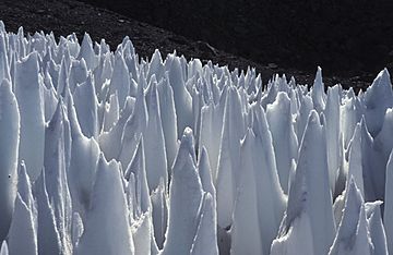
Field of penitentes on the upper Río Blanco, Central Andes of Argentina
|
|
| Highest point | |
| Peak | Aconcagua |
| Elevation | 6,961 m (22,838 ft) |
| Dimensions | |
| Length | 1,200 km (750 mi) |
| Geography | |
| Country | Chile, Northwest Argentina, Bolivia |
| Parent range | Andes |

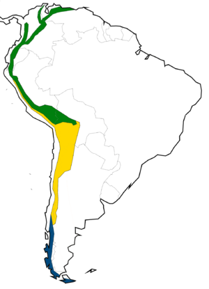
The Dry Andes (in Spanish: Andes áridos) is a special part of the Andes mountains. It's known for its dry climate and unique ice formations. This area is one of two main parts of the Andes in Argentina and Chile.
The Dry Andes stretch from the Atacama Desert in northern Chile and Northwest Argentina. They go south to about 35°S latitude in Chile. In Argentina, they reach even further south, to 40°S. This happens because the Andes block the wind and moisture.
One way to spot the Dry Andes is by looking for "penitentes." These are tall, thin blades of hardened snow or ice. They look like people kneeling in prayer. The southernmost place where you can find many well-formed penitentes is on Lanín Volcano.
You can also find "rock glaciers" in the Dry Andes. These are like slow-moving rivers of rock and ice. They are not found in the more southern Wet Andes. In the Dry Andes, regular glaciers usually form higher up than rock glaciers. Near Aconcagua, rock glaciers can be found as low as 900 meters (about 2,950 feet) above sea level.
The main mountain range near Santiago, Chile, might have had large glaciers a million years ago. This is shown by the shapes of the valleys there.
Ancient Times and Glaciers
Even though it snows more higher up, the nearly 7,000-meter (23,000-foot) tall mountains of the Dry Andes are quite dry. This dry climate is like a subtropic steppe, especially between 32-34°S latitude. Only small shrubs grow in the valley bottoms.
Today, the largest glaciers, like the Plomo glacier, are not very long. Their ice is not very thick either. However, about 20,000 years ago, during the Ice Age, these glaciers were much bigger. They were more than ten times longer!
On the eastern side of the Mendoza Andes, glaciers flowed down to 2,060 meters (6,760 feet). On the western side, they reached about 1,220 meters (4,000 feet). Huge mountains like Cerro Aconcagua (6,962 m or 22,841 ft), Cerro Tupungato (6,550 m or 21,490 ft), and Nevado Juncal (6,110 m or 20,050 ft) were connected by a network of ice streams.
These ice streams were like branches of a giant glacier. They could be up to 112.5 kilometers (70 miles) long. They were also over 1,250 meters (4,100 feet) thick. These massive ice flows covered a vertical distance of 5,150 meters (16,900 feet). The snowline, where glaciers start to form, was much lower back then. It dropped from today's 4,600 meters (15,100 feet) to 3,200 meters (10,500 feet) during the Ice Age.
See also
 In Spanish: Andes áridos para niños
 | Lonnie Johnson |
 | Granville Woods |
 | Lewis Howard Latimer |
 | James West |

