Uturuncu facts for kids
Quick facts for kids Uturuncu |
|
|---|---|

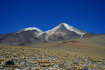
Uturuncu seen from the northwest
|
|
| Highest point | |
| Elevation | 6,008 metres (19,711 ft) |
| Parent peak | Acamarachi |
| Listing | List of mountains in Bolivia |
| Naming | |
| English translation | Jaguar |
| Language of name | Quechua |
| Geography | |
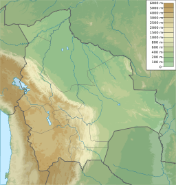
| Location | San Pablo de Lípez Municipality, Sur Lípez Province, Potosí Department, Bolivia |
| Parent range | Cordillera de Lípez |
| Geology | |
| Age of rock | Pleistocene |
| Mountain type | Stratovolcano |
| Volcanic field | Altiplano–Puna volcanic complex |
| Last eruption | 250,000 years ago. |
| Climbing | |
| First ascent | 1955 by Friedrich Adolf Ernest Ahlfeld |
Uturuncu is a huge, inactive volcano in Bolivia. It stands tall at 6,008 metres (19,711 ft) (about 19,711 feet). The volcano has two main peaks at its top. It is made up of many lava domes and lava flows.
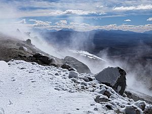
Long ago, glaciers covered parts of Uturuncu. Today, it has no glaciers. The last time Uturuncu erupted was about 250,000 years ago. Even though it hasn't erupted recently, hot gases called fumaroles still escape near its top.
Uturuncu is part of a bigger area called the Altiplano–Puna volcanic complex. This area has many large volcanoes. Scientists have noticed that the ground around Uturuncu has been rising since 1992. This might mean that new magma (molten rock) is moving under the volcano. This could lead to future volcanic activity. Some even wonder if it could become a "supervolcano" again.
Contents
Exploring Uturuncu's Landscape
Uturuncu is located in southern Bolivia. It is found in a very quiet area with few people. For a long time, not many knew about this volcano. But in the early 2000s, scientists found out the ground was moving. This made Uturuncu a very interesting place for research.
The name Uturuncu means 'jaguar' in the Quechua language. Today, people visit Uturuncu to see its amazing views.
First Climbers and Old Mines
The first person to climb Uturuncu was Friedrich Adolf Ernest Ahlfeld in 1955. But it's likely that local miners and people living nearby had climbed it before.
There used to be a sulfur mine near the top of the mountain. It was one of the highest mines in the world! A winding road that miners used still goes up the mountain. Other roads also pass around the base of Uturuncu.
How Tall is Uturuncu?
Uturuncu is the highest mountain in southwestern Bolivia. It rises about 1,510–1,670 metres (4,950–5,480 ft) (around 4,954-5,479 feet) above the land around it. From its top, you can see many other mountains.
The volcano has two peaks. One is 5,930 metres (19,460 ft) (19,455 feet) high, and the other is 6,008 metres (19,711 ft) (19,711 feet) high. They are about 1 kilometre (0.62 mi) (0.6 miles) apart. A lower area called a saddle separates them.
Uturuncu is a type of volcano called a stratovolcano. It has old craters and is made of many lava domes and lava flows. These came out from different openings in the middle of the volcano.
About 105 lava flows spread out from the center of the volcano. Some are as long as 15 kilometres (9.3 mi) (9 miles). The volcano's base covers about 400 square kilometres (150 sq mi) (154 square miles). It seems to be made only of lava flows and domes. Scientists have not found signs of big explosive eruptions.
Water Around the Volcano
Several lakes are found near Uturuncu. Mama Khumu is on its eastern side. Laguna Celeste is to the northeast. Chojllas is southeast, and Loromayu is to the south. The first two lakes get their water from Uturuncu.
You can see old shorelines around these lakes. The Rio Grande de Lípez river flows along the western side of the volcano. This river eventually flows into the Salar de Uyuni, a huge salt flat. These rivers and wetlands are used to raise llamas and sheep.
Uturuncu's Deep History
How Volcanoes Form Here
Uturuncu is part of the Central Volcanic Zone in the Andes mountains. This area has many volcanoes. They form because the Nazca Plate (a large piece of Earth's crust) is slowly sliding under the South American Plate. This process is called subduction.
This region is also home to the Altiplano, a high plateau. It is one of the largest high plateaus in the world, second only to Tibet.
The Giant Magma Body Below
Deep under the ground, about 20 kilometres (12 mi) (12 miles) down, there's a huge area of partially melted rock. This is called the Altiplano–Puna Magma Body. It's like a giant underground lake of magma. It covers an area of 50,000 square kilometres (19,000 sq mi) (19,300 square miles). Scientists think it's the largest magma reservoir in Earth's continental crust.
This magma body is the source of the molten rock for many volcanoes in the area, including Uturuncu. The magma here has a lot of water in it.
Ice and Climate of Uturuncu
Past Glaciers
Today, Uturuncu doesn't have any glaciers. But in the past, it did! Scientists have found signs of old glaciers on its slopes. These signs include scratches on rocks and piles of rock left by glaciers.
During the Pleistocene Ice Age, the snow line was much lower than it is today. This means more snow and ice covered the mountain.
Weather and Plants
There isn't much rain around Uturuncu. Most of the rain falls in December, January, and February. Even though it's cold at the top, there isn't enough snow to form permanent glaciers. However, the summit does get covered in snow sometimes.
The plants are sparse at high elevations. But you can find Polylepis trees on the lower slopes. These trees can grow up to 4 metres (13 ft) (13 feet) tall and form small forests.
When Did Uturuncu Erupt?
Uturuncu was active during the Pleistocene epoch. The oldest lava flows are about 1,050,000 years old. The youngest lava flow found is about 250,000 years old. So, Uturuncu was active for about 800,000 years.
Its eruptions were mostly slow flows of lava. There is no sign of huge explosive eruptions. The volcano is now considered dormant, meaning it's not active but could become active again.
Hot Vents at the Top
Even though Uturuncu hasn't erupted in a long time, there are active fumaroles near its summit. These are vents that release hot gases and steam. You can see the vapor from a distance. The gases contain things like carbon dioxide and hydrogen sulfide. These fumaroles have also left behind a lot of sulfur.
Scientists have used satellites to find hot spots on Uturuncu. These hot spots are caused by the fumaroles. There is also a warm spring on the side of the volcano. These signs suggest there might be a hydrothermal system (underground hot water) deep inside the volcano. There might even be a shallow magma chamber (a pocket of molten rock) about 1–3 kilometres (0.62–1.86 mi) (0.6-1.9 miles) below the surface.
Uturuncu's Recent Changes
Ground Uplift
Since 1992, satellites have shown that a large area around Uturuncu is rising. This uplift has been about 1–2 centimetres (0.39–0.79 in) (0.4-0.8 inches) per year. This movement is likely caused by magma pushing up from deep inside the Earth.
This rising ground is surrounded by an area that is slowly sinking. This pattern is sometimes called a "sombrero pattern." It suggests that magma is moving around under the volcano.
This kind of ground movement is unusual because it has lasted for so long and covers such a large area. It shows that the huge magma body deep below is still active. Scientists have called volcanoes like Uturuncu "zombie volcanoes." This means they have been inactive for a long time but are still showing signs of life, like ground movement.
Earthquakes at the Volcano
Uturuncu also has small earthquakes happening every day. Sometimes, there are bursts of many earthquakes, called seismic swarms. These earthquakes are usually small, but they show that the ground is moving.
Most of these earthquakes happen deep below the volcano. They might be caused by the rising magma putting pressure on cracks in the rocks.
Looking Inside the Volcano
Scientists use special tools to "see" inside the volcano. They use a method called magnetotelluric imaging. This has shown areas of high electrical conductivity deep under Uturuncu. These areas might be where molten rock and salty water are located.
Another method, seismic tomography, has found a tooth-shaped area deep inside. This structure might be where magma is located. Earthquakes tend to happen at the top of this area.
What are the Risks?
Scientists are still studying whether the ground movement at Uturuncu means a new eruption is coming. It's an open question. A very large eruption, like a "caldera-forming eruption," could have huge effects around the world. We've seen this with past eruptions like Mount Tambora in 1815.
However, there is no clear sign that a "super-eruption" is likely to happen soon. There is also no sign of an eruption happening in the near future. But there is a chance for a smaller eruption. Scientists continue to watch Uturuncu closely to understand its activity.
See also
 In Spanish: Uturuncu para niños
- Geology of Bolivia
- List of volcanoes in Bolivia
- Mount Nelly
 | Delilah Pierce |
 | Gordon Parks |
 | Augusta Savage |
 | Charles Ethan Porter |


