
Cordillera de Lípez facts for kids
The Cordillera de Lípez is a large mountain range in South America. It is found in the northern part of the Potosí region in Bolivia. It also stretches into northern Argentina. This mountain range is part of the much larger Andes mountain system, which runs along the western side of South America.
The Cordillera de Lípez covers a huge area, about 23,404 square kilometers (9,036 square miles). It runs from the northeast to the southwest. This range also helps to form part of the border between Bolivia and Argentina. It sits between two other big mountain chains, the Cordillera Oriental and the Cordillera Occidental. Because of its position, the Cordillera de Lípez forms the southern edge of the Bolivian Altiplano, which is a high plateau.
Tallest Peaks and Mountains
The Cordillera de Lípez is home to some very tall mountains. The highest point in the range is a mountain called Uturunku. It stands at an impressive 6,008 meters (19,711 feet) above sea level.
Other Important Mountains
Besides Uturunku, there are other significant peaks in the Cordillera de Lípez:
- Cerro Lípez: This mountain is 5,929 meters (19,452 feet) tall. Sometimes, people mistakenly call it Nuevo Mundo volcano.
- Soniquera: This peak reaches 5,899 meters (19,354 feet). Its name is sometimes spelled Soreguera.
- Tinte: Standing at 5,849 meters (19,190 feet), this mountain is special because it sits right on the border between Bolivia and Argentina.
Even though these mountains are very high, you won't find any large, active glaciers here today. However, there are some areas with snow that stays on the ground for most of the year, called semi-permanent snow fields.
Images for kids
-
Cerro Lípez, 5,929 meters (19,452 ft)
-
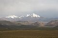
A part of the Cordillera de Lípez in southern Bolivia, near the border with Argentina.


See also
- Cordillera de Lípez para niños (in Spanish)
