Tacora facts for kids
Quick facts for kids Tacora |
|
|---|---|

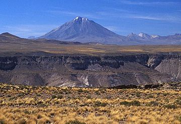
Tacora in 2004
|
|
| Highest point | |
| Elevation | 5,980 m (19,620 ft) |
| Prominence | 1,721 m (5,646 ft) |
| Parent peak | Nevado Sajama |
| Listing | Ultra |
| Geography | |
| Parent range | Andes |
| Geology | |
| Mountain type | Stratovolcano |
| Volcanic arc/belt | Central Volcanic Zone |
| Last eruption | Unknown |
Tacora is a large, cone-shaped volcano in the Andes mountains of Chile. It's located in the Arica y Parinacota Region, very close to the border with Peru. Tacora is one of the northernmost volcanoes in Chile.
This volcano is part of a group called the Central Volcanic Zone. This zone is one of four main areas where volcanoes are found in the Andes. The Central Volcanic Zone is famous for having some of the tallest volcanoes in the world. Tacora itself is a stratovolcano, which means it's built up from many layers of hardened lava and ash. It has a large bowl-shaped hollow at its top called a caldera, and a smaller crater inside. Scientists believe the volcano is at least 50,000 years old. Over time, glaciers have worn down its slopes.
The volcanoes in the Central Volcanic Zone form because the Nazca Plate (a huge piece of the Earth's crust) is slowly sliding under the South American Plate. Tacora sits on a high flat area called the "Arica Altiplano." It's lined up with other volcanoes running from north to south. While there are no confirmed eruptions in recent history, Tacora still has active fumaroles. These are vents that release steam and gases.
The gases from the fumaroles have created large amounts of sulfur on the mountain. People have known about these sulfur deposits for centuries. In the late 1800s, people started mining the sulfur. They built a lot of special equipment and buildings on the mountain to help with the mining.
Contents
Where is Tacora?
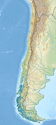
Tacora is located in the Arica y Parinacota Region of Chile. It's about 100 kilometers (62 miles) northeast of the city of Arica. It is one of the volcanoes farthest north in Chile.
Tacora is part of the Central Volcanic Zone. This zone is a major area for volcanoes around the world. It has many volcanoes, and some are very tall. Other volcanoes in this zone include Sabancaya and El Misti in Peru. In Chile, Bolivia, and Argentina, you can find volcanoes like Isluga and Lascar. Lascar is known for being very active, with a big eruption in 1993. Besides volcanoes, the Central Volcanic Zone also has hot springs, like El Tatio.
What Tacora Looks Like
Tacora is a tall, cone-shaped mountain, reaching 5,980 meters (19,620 feet) high. At its top, there's a large caldera that opens towards the northwest. Inside the caldera, there's a 500-meter (1,640-foot) wide crater. The volcano is mostly made of steep lava flows, along with lava domes and rocky material from eruptions. It rises about 1.7 kilometers (1.1 miles) above the land around it.
The volcano has been worn down a lot over time, but it still keeps its round shape. There are signs that a part of the volcano once collapsed. This caused a large landslide on its southeastern side.
Glaciers and Water
Some reports say there are still glaciers inside the caldera of Tacora, high up at 5,500 meters (18,045 feet). However, other reports say there is no permanent snow on the mountain. But there are clear signs that glaciers used to cover the mountain. You can see glacial valleys and piles of rock left by glaciers on the eastern, southeastern, and southern slopes. Bowl-shaped hollows called cirques are found at 5,000 meters (16,400 feet) high.
These landforms show that the mountain was once covered in ice. Scientists have found different sets of moraines (piles of rock left by glaciers). Some of these moraines are very old. There are also some rock glaciers still present. Unlike other glaciers in Chile, these rock glaciers on Tacora are not shrinking.
Tacora is an important source of water for the area. The Lluta River starts on Tacora. Its water is quite salty because it comes from the volcano. Other rivers and canals also flow near Tacora, providing water to the region.
Hot Springs and Geothermal Energy
On the western and northwestern sides of Tacora, there are solfataras. These are places where steam and gases come out of the ground. The Aguas Calientes de Tacora hot springs are located about 2 kilometers (1.2 miles) southwest of the volcano. There are also cone-shaped rocks that show geysers used to be active here.
Scientists have used special tools to study the hot water systems and magma (molten rock) deep inside the volcano. Tacora has been explored for its potential to produce geothermal power. This means using the Earth's heat to make electricity. In 2009, the Chilean government asked for proposals to develop geothermal energy at Tacora. One plan was approved in 2010.
Fumaroles and Gases
The gases coming out of the fumaroles are mostly water vapour. They also contain other gases like carbon dioxide, hydrogen sulfide (which smells like rotten eggs), and sulfur dioxide. Small amounts of hydrogen and methane are also present. The temperatures of these fumaroles range from 82 to 93 degrees Celsius (180 to 199 degrees Fahrenheit).
Scientists believe these gases come from water that has evaporated after being heated by the volcano. This heated water also creates acid hot springs. There seems to be a hot water system deep under the volcano, with temperatures between 270 and 310 degrees Celsius (518 and 590 degrees Fahrenheit). There is also a magma system about 2 kilometers (1.2 miles) below the surface. The gases from the fumaroles pass through these systems before reaching the surface.
How Tacora Formed
The volcanism in the Andes is caused by the Nazca Plate sliding under the South America Plate. This process is called subduction. This volcanic activity doesn't happen along the entire length of the Andes. Instead, it occurs in specific areas called volcanic belts. Tacora is in the Central Volcanic Zone.
Volcanoes in this part of the Andes are usually between 1,500 and 3,000 meters (4,900 and 9,800 feet) tall above the ground they sit on. They are made of lava flows and pyroclastic rocks (broken rock fragments from eruptions).
The land beneath Tacora is called the Arica Altiplano. It's a high plateau about 4,200 meters (13,780 feet) high. This area is made of different types of sedimentary and volcanic rocks. Tacora, along with a few other volcanoes, forms a 10-kilometer (6.2-mile) long line of volcanoes that stretches into Peru.
What Tacora is Made Of
Tacora is mainly made of a type of volcanic rock called dacite, with smaller amounts of andesite. These rocks form the lava flows and pyroclastic material. The rocks contain minerals like biotite, hornblende, and plagioclase.
Tacora's Eruptive History
Tacora was active during the Pleistocene and Holocene epochs, which means it erupted less than 700,000 years ago. One rock sample from the volcano was dated to be about 490,000 years old. Another sample from the upper western side is about 50,000 years old. The crater and lava flows on the southern side are likely the most recent signs of volcanic activity.
There are old stories that Tacora "collapsed" during a big earthquake in 1877. There are also single reports of activity in 1830, 1930, 1937, 1939, and 1950. However, scientists generally believe Tacora has not had any confirmed eruptions in recorded history. The only ongoing activity is the release of gases from fumaroles and small earthquakes. If Tacora were to become active again, the southern, eastern, and western slopes would likely be most affected. The nearby town of Tacora could be in danger. Volcanic ash could also reach towns farther away, like Visviri.
Sulfur Mining on Tacora
Large amounts of sulfur are found between Tacora and another mountain called Chupiquiña. This sulfur has been mined on the northwestern side of Tacora. The sulfur deposits on Tacora are among the biggest in Chile. Thick layers of sulfur cover areas of 0.2 to 0.3 square kilometers (0.077 to 0.116 square miles) in the crater and on the northern and eastern slopes. The active fumaroles are still creating new sulfur deposits today.
Sulfur deposits are common on volcanoes in northern Chile. The sulfur forms mainly from hydrogen sulfide gas in steam. This gas turns into solid sulfur in rock cavities. These sulfur deposits often come with discolored rocks, as the process changes the rock formations. These colors can be seen from far away. Besides sulfur, these deposits often contain other elements like antimony and arsenic. Acidic water from the mines has caused pollution in the Azufre River, which flows into the Lluta River.
The earliest records of sulfur on Tacora date back to 1637. Sulfur mining in Chile began in the late 1800s. This happened because the world needed more sulfur for the chemical industry and other uses. In the early 1900s, sulfur mining was very important in northern Chile. Many pure sulfur deposits were found from the Peruvian border down to the Puna de Atacama region.
Several companies mined sulfur on Tacora volcano. Much of the mining equipment and buildings were on the upper northwestern slopes. This included cableways, offices, workers' camps, and processing plants. In 1952, it was estimated that Tacora had at least 2,000,000 tons of sulfur ore. In 1922, Tacora was considered the most important sulfur deposit in the Andes.
The sulfur was transported using a special railroad down to Villa Industrial. From there, it was moved to Arica using the Arica-La Paz railway. From Arica, the sulfur was shipped all over South America. This railway, opened in 1913, made it possible to fully use Tacora's sulfur deposits. It's interesting to note that the 1929 border agreement between Peru and Chile specifically placed Tacora's sulfur deposits entirely within Chilean territory.
Most of the workers in the Tacora mines were local indigenous people. They were used to the harsh climate conditions on the high slopes of Tacora. The mining operations also showed how a new, modern culture was brought into the region.
Mythology
In the Central Andes, it's common for people to worship mountains. In local stories, Tacora and Sajama were two mountains that competed for two women (the Nevados de Payachata). In some versions of the myth, the two women drove Tacora away and removed the top of the mountain. In other versions, Sajama did it and hurt Tacora. Tacora then ran away, leaving behind blood and a piece of its heart.
Plants on Tacora
The plant species Astragalus tacorensis is named after the volcano. This is because the first time this plant was officially described, it was found on Tacora. Another flowering plant, Pycnophyllum macropetalum, also has its main discovery location at Tacora.
See also
 In Spanish: Volcán Tacora para niños
- List of volcanoes in Chile
- List of Ultras of South America
 | Audre Lorde |
 | John Berry Meachum |
 | Ferdinand Lee Barnett |


