
Los Ríos Region facts for kids
Quick facts for kids Los Ríos Region (XIV Región de Los Ríos) |
|||
| Region of Chile | |||
|
|||
| Country | |||
|---|---|---|---|
| Provinces | Valdivia, El Ranco | ||
| Capital | Valdivia | ||
| - coordinates | 39°48′30″S 73°14′30″W / 39.80833°S 73.24167°W | ||
| Highest point | Villarrica | ||
| - elevation | 2,860 m (9,383 ft) | ||
| Lowest point | Pacific Ocean | ||
| - elevation | 0 m (0 ft) | ||
| Area | 18,429.5 km² (7,116 sq mi) | ||
| Population | 407,300 (2016) | ||
| Density | 22 /km² (57 /sq mi) | ||
| Intendant | Ricardo Millán | ||
| ISO 3166-2 | CL-LR | ||


The Los Ríos Region (which means Region of the Rivers in Spanish) is one of Chile's 16 main administrative divisions. It's known as the XIV (14th) region. Its capital and largest city is Valdivia.
This region started operating in 2007. It was created by splitting off a part of the Los Lagos Region in southern Chile. Los Ríos is made up of two provinces: Valdivia and the newer El Ranco province. El Ranco used to be part of Valdivia province.
Contents
Exploring the Los Ríos Region's Geography
The Los Ríos region covers an area of about 18,429.5 km2 (7,115.7 sq mi). That's roughly the size of a small country!
It shares borders with different areas:
- To the north, it meets the La Araucanía region.
- To the east, it borders Argentina.
- To the south, you'll find the Los Lagos region.
- To the west, it touches the vast Pacific Ocean.
Rivers and Mountains in Los Ríos
Two important rivers flow through this region. The Valdivia River is in the northern part, and the Bueno River is in the southern part.
The highest point in the region is the Villarrica volcano. It's a tall mountain, about 2,860 m (9,380 ft) high. This volcano is located close to the border with Argentina.
Population and Main Cities
In 2002, the Los Ríos region had a population of 356,396 people. This means there were about 19.3 people living in each square kilometer.
The biggest city in the region is its capital, Valdivia. In 2002, Valdivia had 127,750 residents. The capital of the other province, La Unión, had 25,615 residents.
How Los Ríos is Governed
The Los Ríos region is divided into two main parts called provinces. These are Valdivia and El Ranco.
Each province is then divided into smaller areas called comunas (communes). There are 12 communes in total across the two provinces.

Gallery


Related pages
| Regions of Chile | |
|---|---|
| Arica y Parinacota | Tarapacá | Antofagasta | Atacama | Coquimbo | Valparaíso | O'Higgins | Maule | Bío Bío | La Araucanía | Los Ríos | Los Lagos | Aysén | Magallanes y la Antártica Chilena | RM Santiago | |
Images for kids
-
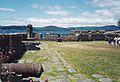
Valdivian Fort System founded by the Spaniards in Corral.
-
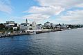
Valdivia.
-
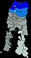
Map of the Los Ríos Region and the remaining Los Lagos Region (Grey).
-
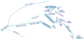
Map of the drainage network of Valdivia River. Valdivia River empties into Corral Bay in the Pacific Ocean. View of Panguipulli Lake.

.jpg)


See also
 In Spanish: Región de Los Ríos para niños
