Valdivia River facts for kids
Quick facts for kids Valdivia River (Río Valdivia) |
|
|---|---|

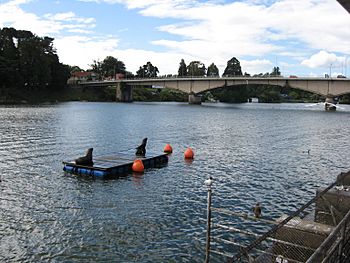
View of the upper course of Valdivia River. Pedro de Valdivia Bridge is seen in the background.
|
|

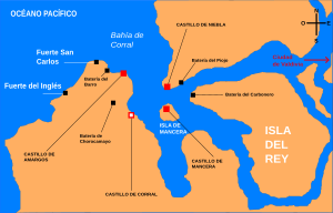
Map of the mouth of the Valdivia
|
|
| Country | Chile |
| Physical characteristics | |
| Main source | Calle-Calle River, Caucau River |
| River mouth | Corral Bay, Pacific Ocean 0 m (0 ft) 39°52′37″S 73°22′56″W / 39.87694°S 73.38222°W |
| Length | 15 km (9.3 mi) |
| Basin features | |
| Basin size | 10,275 km2 (3,967 sq mi) |
| Basin population | 168,489 |
The Valdivia River, also known as Río Valdivia, is an important river in southern Chile. It starts where the Calle-Calle River and the Cau-Cau River meet. This meeting point is in the city of Valdivia.
The Valdivia River flows into Corral Bay. This bay is part of the huge Pacific Ocean.
About the Valdivia River
The Valdivia River is not very long, only about 15 kilometers (9 miles). But it is a very wide and deep river. It carries a lot of water from its many smaller rivers.
Where Does It Flow?
The Valdivia River is formed by two rivers coming together. These are the Calle-Calle River and the Cau-Cau River. They meet right in the city of Valdivia.
Other rivers also join the Valdivia River. These are the Cruces River, the Tornagaleones River, and the Futa River. All these rivers add their water to the Valdivia.
The river then flows west towards the coast. It finally empties into Corral Bay. This bay is a part of the Pacific Ocean.
Important Bridges
One famous bridge crosses the Valdivia River. It is called the Pedro de Valdivia Bridge. This bridge is located right in the center of Valdivia city. It helps people and cars cross the river easily.
See also
 In Spanish: Río Valdivia para niños
 | James B. Knighten |
 | Azellia White |
 | Willa Brown |

