Corral, Chile facts for kids
Quick facts for kids
Corral
|
||||||
|---|---|---|---|---|---|---|
|
Town and Commune
|
||||||

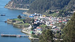
View of Corral from the hills
|
||||||
|
||||||
| Country | Chile | |||||
| Region | Los Ríos | |||||
| Province | Valdivia | |||||
| Founded | 1894 | |||||
| Government | ||||||
| • Type | Municipality | |||||
| Area | ||||||
| • Total | 766.7 km2 (296.0 sq mi) | |||||
| Elevation | 61 m (200 ft) | |||||
| Population
(2012 census)
|
||||||
| • Total | 5,084 | |||||
| • Density | 6.6310/km2 (17.1743/sq mi) | |||||
| • Urban | 3,670 | |||||
| • Rural | 1,793 | |||||
| Demonym(s) | Corraleño | |||||
| Sex | ||||||
| • Men | 2,864 | |||||
| • Women | 2,599 | |||||
| Time zone | UTC−04:00 (CLT) | |||||
| • Summer (DST) | UTC−03:00 (CLST) | |||||
| Area code(s) | 56 + 63 | |||||
| Climate | Cfb | |||||
| Website | Municipality of Corral | |||||
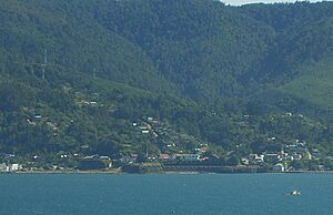
Corral is a town, a commune, and a sea port in Valdivia Province, Los Ríos Region, Chile. It is located on the southern side of Corral Bay. Long ago, during the time when Spain ruled Chile, Corral was the main base for the Valdivian Fort System. This system of forts was built to protect the important city of Valdivia from attacks.
Today, the people of Corral work in different areas. These include forestry (working with forests and wood), aquaculture (farming fish or shellfish), fishing, and providing services for ships at the port. Many people also work in tourism, helping visitors explore the town's history and natural beauty. You can reach Corral by road from Valdivia and Caleta Chaihuín. There is also a ferry that connects it to Niebla.
Contents
History of Corral

The town of Corral started as the main base for the Valdivian Fort System. This system was built in 1645 to protect the city of Valdivia. At first, Spanish ships would sail up the Valdivia River to reach Valdivia. But soon, Corral became the main place where large ships would arrive.
The fort in Corral had only a few cannons until 1749. Later, between 1767 and 1773, the fort was made much stronger. This was done to improve the defense of Valdivia. The modern town of Corral grew around the fort, which was called Castillo de Corral. By 1798, about 49 people lived outside the fort walls.
Corral During Chile's Independence
During the Chilean Independence War, Corral and Valdivia were important places for those who wanted to stay loyal to the Spanish king. In 1820, a brave commander named Thomas Cochrane led the new Chilean Navy. He launched a surprise attack by sea and land, capturing both Corral and Valdivia.
In the early 1900s, Corral was a very busy port. Ships from all over the world would stop there. This was because Chilean ports were open to ships from any country. In 1847–1848, sawmills that used water power were built in Corral.
Why Corral Changed
Corral's economy faced many challenges in the 20th century. New train routes connected Valdivia and other cities to central Chile. Also, the opening of the Panama Canal meant ships no longer needed to sail around South America. This caused Corral to lose most of its shipping traffic.
In 1910, a large steel mill opened in Corral. It was the biggest in South America at the time. However, it was expensive to run and needed many workers. The steel mill eventually closed in 1958 because it was not making enough money.
For a time, Corral was also an important port for whaling (hunting whales). The whaling industry stopped during the First World War because it was hard to get supplies. It started again after the war, but then slowly declined in the 1960s. Whaling completely ended in Chile in 1983. You can still see parts of the old whaling buildings on land.
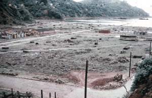
The biggest challenge for Corral happened in 1960. The Great Chilean Earthquake struck, which was the largest earthquake ever recorded. It destroyed many houses, roads, and port buildings. A huge tsunami followed, wiping out the neighborhood of Corral Bajo. About 30% of nearby Corral Alto was also destroyed. Many families moved to a new neighborhood called La Aguada after the earthquake. As of 2015, only one pier remains, used by a company to ship wood chips.
Corral's Population
According to a census from 2002, Corral covers an area of 766.7 square kilometers. It had 5,463 people living there at that time. Out of these, 2,864 were men and 2,599 were women. Most people (67.2%) lived in urban areas, while 32.8% lived in rural areas. The population of Corral decreased by 5.2% between 1992 and 2002.
How Corral is Governed
Corral is a commune, which is a local administrative area in Chile. It is managed by a municipal council. The head of the council is an alcalde (mayor), who is chosen by the people every four years.
Corral is part of the 53rd electoral district for the Chamber of Deputies. This means its citizens vote for representatives who also represent Valdivia, Lanco, Mariquina, and Máfil. For the Senate, Corral is part of the 16th senatorial constituency, which covers the entire Los Ríos Region.
 |
Valdivia |  |
||
| Pacific Ocean | Paillaco | |||
| La Unión |
See also
 In Spanish: Corral (Chile) para niños
 | John T. Biggers |
 | Thomas Blackshear |
 | Mark Bradford |
 | Beverly Buchanan |


