La Unión, Chile facts for kids
Quick facts for kids
La Unión
|
||||||
|---|---|---|---|---|---|---|

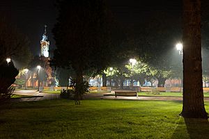
Plaza de la Concordia, La Unión
|
||||||
|
||||||
| Country | Chile | |||||
| Region | Los Ríos | |||||
| Province | Ranco | |||||
| Founded as | Villa de San José de La Unión | |||||
| Founded | 13 February 1821 | |||||
| Government | ||||||
| • Type | Municipality | |||||
| Area | ||||||
| • Total | 2,136.7 km2 (825.0 sq mi) | |||||
| Elevation | 28 m (92 ft) | |||||
| Population
(2012 census)
|
||||||
| • Total | 36,447 | |||||
| • Density | 17.0576/km2 (44.1790/sq mi) | |||||
| • Urban | 25,615 | |||||
| • Rural | 13,832 | |||||
| Demonym(s) | unionino | |||||
| Sex | ||||||
| • Men | 20,125 | |||||
| • Women | 19,322 | |||||
| Time zone | UTC−4 (CLT) | |||||
| • Summer (DST) | UTC−3 (CLST) | |||||
| Area code(s) | 56 + 63 | |||||
| Climate | Cfb | |||||
| Website | Official website: http://www.munilaunion.cl/ | |||||
La Unión is a city and a commune (like a local area) in the Ranco Province of the Los Ríos Region in Chile. It's about 40 kilometers north of Osorno and 80 kilometers southeast of Valdivia.
The city covers an area of 2,136.7 square kilometers. In 2012, about 36,447 people lived there, with most (25,615) living in the city itself. Its name, La Unión, comes from where the Llollelhue and Radimadi rivers meet.
La Unión was founded in 1821 by Bernardo O'Higgins. This was done to make sure Chile controlled the southern part of the Central Valley near Valdivia. Today, La Unión is a big center for producing milk. A company called COLUN is the main producer of milk and dairy products in the area.
To the west of the city, you'll find many forests. The eastern part of the commune has a lot of farms, part of an area called Los Llanos. The Alerce Costero National Park is located in the mountains to the west. Until 2001, many people who worked in the coal mines of Catamutún lived in La Unión.
Population and Area of La Unión
According to the 2002 census by the National Statistics Institute, La Unión covers an area of 2,136.7 square kilometers. It had 39,447 people living there at that time. This included 20,125 men and 19,322 women.
Most of the people (25,615, or about 65%) lived in the city areas. The rest (13,832, or about 35%) lived in the countryside. Between 1992 and 2002, the population grew by 1.8%, which means 707 more people.
How La Unión is Governed
La Unión is a commune, which is a local administrative area in Chile. It is managed by a municipal council. The council is led by an alcalde (mayor), who is chosen directly by the people every four years. From 2012 to 2016, the mayor was María Angelica Astudillo Mautz.
La Unión is part of the 54th electoral district for the Chamber of Deputies. This means its people help choose representatives like Mr. Enrique Jaramillo and Mr. Gastón Von Mühlenbrock. This district also includes other towns like Panguipulli, Los Lagos, Futrono, Lago Ranco, Río Bueno, and Paillaco.
The commune is also part of the 16th senatorial constituency (Los Ríos Region) for the Senate during the 2014–2022 period by Alfonso de Urresti (PS) and Ena von Baer (UDI).
 |
Corral | Paillaco |  |
|
| Pacific Ocean | Futrono Lago Ranco |
|||
| San Juan de la Costa San Pablo |
Río Bueno |
Education in La Unión
The Deutsche Schule La Unión (German School of La Unión) was once recognized as an overseas German school. This recognition came from the West German government.
See also
 In Spanish: La Unión (Chile) para niños
 | Shirley Ann Jackson |
 | Garett Morgan |
 | J. Ernest Wilkins Jr. |
 | Elijah McCoy |


