
Alerce Costero National Park facts for kids
Quick facts for kids Alerce Costero National Park |
|
|---|---|
|
IUCN Category III (Natural Monument)
|
|
 |
|

Alerce Costero National Park
Location in Chile
|
|
| Location | La Unión, Chile commune, Los Ríos Region, Chile |
| Nearest city | La Unión, Chile |
| Area | 139.75 km2 (53.96 sq mi) |
| Established | 1987 National Reserve, 2010 National Park |
| Governing body | Corporación Nacional Forestal |
Alerce Costero National Park (which means Coastal Fitzroya National Park in Spanish) is a special protected area in Chile. It's located in the Cordillera Pelada mountains. This park is about 137 kilometers (85 miles) from Valdivia and 49 kilometers (30 miles) from La Unión.
The park gets its name from the amazing Fitzroya trees that grow there. These trees are also called Alerce in Spanish. The park helps protect these ancient trees and the unique nature around them.
Contents
History of Alerce Costero National Park
Alerce Costero National Park started as a smaller protected area. It was first called the Alerce Costero National Monument. The Chilean government created it on January 3, 1987.
Later, in 2010, this area became a full national park. It was then renamed Alerce Costero National Park. This new park was created thanks to a team effort. The government joined its Alerce Costero National Monument and Valdivia National Reserve with land given by The Nature Conservancy. This made the park much bigger and more protected.
About the Park
The CONAF manages Alerce Costero National Park. CONAF is like the park service in Chile. The park covers a total area of 137 square kilometers (53 square miles). Its highest point is about 1,048 meters (3,438 feet) above sea level.
The park's special geography is perfect for many unique animals and plants. These species need very specific places to live.
Why the Park is Important
One main goal of the park is to protect the Valdivian temperate rain forest. This is a type of forest that gets a lot of rain all year. The park also helps keep the Chaihuín river basin healthy. This river is very important for the region and for the Chaihuín community that lives nearby.
The southern Chilean Coast Range and its Valdivian temperate rain forest are very special. This area is a top priority for protecting different kinds of plants and animals. The mountains here helped protect life during the last ice age. They also offered safety from volcanoes. However, human activities have caused some damage, and the area is now considered threatened.
Fires in the Past
From about 1750 to 1943, many fires happened in the Fitzroya forests of Cordillera Pelada. These fires were started by people as the land was settled. Even before that, from 1397 to 1750, Fitzroya forests also had fires. These earlier fires were caused by lightning or by local people.
Climate in the Park
The area around Valdivia and the Los Ríos Region has a rainy, mild climate. This means it rains throughout the whole year.
Alerce Costero National Park is a bit warmer than other parts of the region. The average temperature for the year is 12° Celsius (54° Fahrenheit). In January, the warmest month, temperatures are around 17.2° Celsius (63° Fahrenheit). In July, the coldest month, temperatures are about 7.6° Celsius (46° Fahrenheit).
How to Get There

Alerce Costero National Park is part of the Valdivian temperate rain forest. It is located in the Coastal Range. The park is in the areas of Corral and La Unión. Roads to the park are getting better, but it's still a good idea to use a four-wheel drive vehicle.
Access from Corral
The main way to get to the park from Corral is by route T-80. This road goes to the seaside village of Hueicolla. Part of the road is gravel, and part is dirt. It's best for off-road vehicles or mountain bikes. There's another route for regular cars through La Unión and Santa Elisa.
Other ways to reach the park from Corral (for four-wheel drives and mountain bikes only) include:
- West Entrance: From the town of Chaihuín, heading towards the Catrileufu area.
- North Entrance (Route T-470): To the Quitaluto-Catrilelfu zone.
- North Entrance (Morro Gonzalo): From the town of Morro Gonzalo.
- Route T-60 Entrance: From the Valdivia – La Union Highway (Route T-640) in the Tres Chiflones zone, towards La Romaza.
Access from La Unión
- South Entrance (Santa Elisa): From the town of Santa Elisa in La Unión to the La Romaza area. This road is in good condition for all vehicles.
- Route T-80 Entrance: From La Unión to the Alto Mirador area. This gravel road is also good for all vehicles.
You can also get to the park by boat on the Chaihuín river. There's also a 60-kilometer (37-mile) four-wheel drive route from the coast.
Main Features and Activities
It's free to enter Alerce Costero National Park. The park is open every day from 9:00 AM to 8:00 PM.
As the name suggests, the most amazing part of the park is its ancient Fitzroya trees. Some of these trees are thousands of years old! You can find many of them in the southern part of the park.
The park's evergreen forest has some areas that look burnt. These are places where forest fires left their mark. This is why the area is sometimes called "Cordillera Pelada," meaning "Bald Mountains."
The park is a great place for hiking and horseback riding. There are many spots to see the plants, animals, and beautiful views. It's also very popular for mountain biking.
In the northern part of the park (Catrilelfu, Las Romazas), you'll find a CONAF office. Park rangers are there to help with information and safety tips. You can also find toilets and trash cans around the park.
The park has two main official walking trails in the southern area. More than 100 kilometers (62 miles) of new trails are being explored for visitors.
- Alerce Milenario (Ancient Fitzroya) Route: This 1,800-meter (5,900-foot) trail leads to a 3,000-year-old Fitzroya tree. This tree is about 4.5 meters (15 feet) wide!
- Piedra del Indio (Indian Stone) Route: This trail takes you to a spot with great views of the mountains and river. Here you can see "Ciprés de las Guaitecas" trees, also known as (Pilgerodendron).
There is also a camping area with tables, a wooden shelter, and information for campers.
Flora and Fauna
Alerce Costero National Park is home to many different kinds of plants and animals.
- Flora (Plants)
- Alerce (Fitzroya) - The famous ancient trees
- Canelo (Drimys winteri)
- Ciprés de las Guaitecas (Pilgerodendron)
- Tineo (Weinmannia trichosperma)
- Coigüe de Chiloé (Nothofagus nitida)
- Two types of carnivorous plants: "rocio del sol" (Drosera uniflora) and "violeta del pantano" (Pinguicula chilensis)
- Fauna (Animals)
- Güiña (kodkod) - A small wild cat
- Puma (Felis concolor or cougar) - A large wild cat
- Quique (lesser grison) - A type of weasel
- Pudú - One of the smallest deer in the world
- Carpintero negro (Magellanic woodpecker) - A large black woodpecker
Images for kids
-
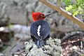
Black or Magellanic woodpecker

.jpg)
See Also
 In Spanish: Parque nacional Alerce Costero para niños
- List of national parks of Chile
