
Atacama Region facts for kids
- This article is about the Atacama Region; for the desert, see Atacama Desert.
Quick facts for kids Atacama Region (III Región de Atacama) |
|||
| Region of Chile | |||
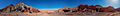
 Laguna Santa Rosa, Atacama
|
|||
|
|||
| Country | |||
|---|---|---|---|
| Provinces | Chañaral, Copiapó, Huasco | ||
| Capital | Copiapó | ||
| - coordinates | 27°22′34″S 70°19′24″W / 27.37611°S 70.32333°W | ||
| Highest point | Nevado Ojos del Salado | ||
| - elevation | 6,893 m (22,615 ft) | ||
| - coordinates | 27°06′S 68°32′W / 27.100°S 68.533°W | ||
| Lowest point | Sea level | ||
| - elevation | 0 m (0 ft) | ||
| Area | 75,176.2 km² (29,026 sq mi) | ||
| Population | 312,486 (2015) | ||
| Density | 4 /km² (10 /sq mi) | ||
| Intendant | Miguel Vargas Correa | ||
| ISO 3166-2 | CL-AT | ||


The Atacama Region (also known as III Región de Atacama in Spanish) is one of Chile's 15 main administrative areas. Think of it like a large state or province. A big part of the famous Atacama Desert is found here. The rest of this desert stretches into other regions further north.
The main city and capital of the Atacama Region is Copiapó. It is about 806 kilometers (500 miles) north of Santiago, which is Chile's capital city.
Contents
History of the Atacama Region
The Atacama area has been important in Chile for a long time. From 1843, it was known as a province. Later, in 1974, Chile changed its system of how it organized its land. That's when the Atacama area officially became one of the country's regions.
Geography of the Atacama Region
The Atacama Region is located in a very interesting part of South America.
 |
Tarapacá region | Catamarca province (Argentina) | |
|
| Pacific Ocean | La Rioja province (Argentina) | |||
| Coquimbo region | San Juan province (Argentina) |
To the north, it shares a border with the Tarapacá Region. To the east, it meets Argentina, touching its Catamarca, La Rioja, and San Juan provinces. The Coquimbo Region is to its south. On the west side, the region has a long coastline along the Pacific Ocean.
Mountains in Atacama
The Atacama Region is home to some very tall mountains. The highest one is Nevados Ojos del Salado. It stands at an amazing 6,893 meters (22,615 feet) high. Another tall peak is Nevado Tres Cruces, which is 6,748 meters (22,139 feet) high. These mountains are part of the Andes mountain range. They are located right on the border with Argentina.
Population of Atacama
In 2015, it was estimated that about 312,486 people lived in the Atacama Region. This means that for every square kilometer of land, there were about 4.2 people living there. This is called the population density.
The biggest city in the region is its capital, Copiapó. In 2002, about 125,983 people lived in Copiapó.
Administration of Atacama
The Atacama Region is divided into three smaller areas called provinces. These provinces are Chañaral, Copiapó, and Huasco. Each province has its own capital city and smaller towns called comunas.

| Provinces | Capital | Code | Comunas | Area (km²) |
Population 2002 |
|---|---|---|---|---|---|
| Copiapó (031) |
Copiapó | 03101 | 4 Copiapó | 16,681.3 | 129,091 |
| 03102 | 3 Caldera | 4,666.6 | 13,734 | ||
| 03103 | 5 Tierra Amarilla | 11,190.6 | 12,888 | ||
| Total for Copiapó Province | 32,538.5 | 155,713 | |||
| Chañaral (032) |
Chañaral | 03201 | 1 Chañaral | 5,772.4 | 13,543 |
| 03202 | 2 Diego de Almagro | 18,663.8 | 18,589 | ||
| Total for Chañaral Province | 24,436.2 | 32,132 | |||
| Huasco (033) |
Vallenar | 03301 | 9 Vallenar | 7,083.7 | 48,040 |
| 03302 | 6 Alto del Carmen | 5,938.7 | 4,840 | ||
| 03303 | 7 Freirina | 3,577.7 | 5,666 | ||
| 03304 | 8 Huasco | 1,601.4 | 7,945 | ||
| Total for Huasco Province | 18,201.5 | 66,491 | |||
| Total for the Region | 75,176.2 | 254,336 | |||
Related pages
| Regions of Chile | |
|---|---|
| Arica y Parinacota | Tarapacá | Antofagasta | Atacama | Coquimbo | Valparaíso | O'Higgins | Maule | Bío Bío | La Araucanía | Los Ríos | Los Lagos | Aysén | Magallanes y la Antártica Chilena | RM Santiago | |
Images for kids
-
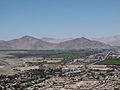
Irrigated fields in the outskirts of Copiapó.
-
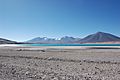
Laguna Verde, a beautiful green lake.
-
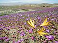
The desert in bloom after rare rains.
-
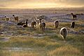
Llamas enjoying the sunset in the desert.
-
Rainbow Valley, known for its colorful hills.


See also
 In Spanish: Región de Atacama para niños
