
Santiago Metropolitan Region facts for kids
Quick facts for kids
Santiago Metropolitan Region
Región Metropolitana de Santiago
|
|||
|---|---|---|---|
.png)
Montage of Santiago Metropolitan Region
|
|||
|
|||

Map of Santiago Metropolitan Region
|
|||
| Country | |||
| Capital | Santiago | ||
| Provinces | Santiago, Chacabuco, Cordillera, Maipo, Melipilla, Talagante | ||
| Area | |||
| • Total | 15,403.2 km2 (5,947.2 sq mi) | ||
| Area rank | 15 | ||
| Highest elevation | 6,570 m (21,560 ft) | ||
| Population
(2017)
|
|||
| • Total | 7,036,792 | ||
| • Rank | 1 | ||
| • Density | 456.8396/km2 (1,183.209/sq mi) | ||
| ISO 3166 code | CL-RM | ||
| HDI (2019) | 0.883 very high |
||
| Website | Gobierno Regional Metropolitano de Santiago | ||


The Santiago Metropolitan Region (or Región Metropolitana de Santiago in Spanish) is one of Chile's 16 main regions. It's the only region in Chile that doesn't touch the ocean, and it's home to Chile's capital city, Santiago.
This region is where most of Chile's businesses and government offices are found. It also has Chile's biggest international airport, Arturo Merino Benítez International Airport.
It covers about 15,403 square kilometers (5,947 square miles) and has over 7 million people. This makes it Chile's most populated region and the most crowded.
Contents
History of the Santiago Metropolitan Region
The history of European influence in this region began in 1542. This was just a few days after the city of Santiago was founded.
When the Santiago cabildo (a type of city council) was built, it was meant to oversee the entire area. Later, as new cities like La Serena and Concepción were created with their own councils, the Santiago council's area of control became smaller.
On August 30, 1826, Chile created 8 provinces. The Santiago Province was one of them. However, the Santiago Metropolitan Region as we know it today wasn't officially created until 1980.
Geography and Natural Features
The Santiago Metropolitan Region is unique because it's the only region in Chile that is completely surrounded by land. It sits in a valley called the Intermediate Depression. This valley is located between two mountain ranges: the Chilean Coast Range and the mighty Andes mountains.
Mountains and Rivers

Cerro San Cristóbal is a famous hill that stands tall over Santiago. It is about 880 meters (2,887 feet) above sea level. You can see city neighborhoods steadily climbing the foothills of the Andes to the east.
On the border with Argentina, you'll find the Tupungato volcano. This huge volcano is about 6,570 meters (21,555 feet) high. It is one of the tallest peaks in South America.
The main river system in the region is the Maipo River. Its most important smaller rivers are the Mapocho, Yeso, and Colorado rivers.
Climate and Environment
The climate in the Metropolitan Region is a type of cold Mediterranean climate. This means it has clear seasons. Most of the rain falls during the winter months. This rain often turns into snow above 900 meters (2,953 feet) above sea level. In very cold years, it can even snow in the city of Santiago.
Winters are usually cold, with many frosty days when temperatures drop below 0°C (32°F). Summers are typically dry and hot. The Cordillera de la Costa (Coast Range) acts like a shield. It blocks some of the ocean's influence, making the climate more "continental." This is why Santiago gets less rain (360 mm) than a coastal city like Valparaíso (460 mm).
The average yearly rainfall is about 367 mm (14.4 inches). The average yearly temperature is around 13.5°C (56.3°F). In city areas, the average high is 21°C (70°F) and the average low is 6°C (43°F). Rural areas can be colder, with temperatures dropping to -10°C (14°F) in the coldest months (July and August).
Most of the region is a very fertile, flat plain. Locals call this area la Depresión intermedia (the Intermediate Depression). This land is known for being low in elevation. It is surrounded by hills and also has "island hills" that rise up from the flat land. Examples include Santa Lucía (an old volcano), Blanco, and Renca, which are now part of the city of Santiago.
You can find the endangered Chilean Wine Palm, Jubaea chilensis, in Santiago Province. This special tree used to cover a much larger area. However, much of its habitat was lost as the human population grew.
Economy and Culture
The main industries in the Santiago Metropolitan Region include making things (manufacturing), providing services, selling goods (retail), and financial services.

Santiago, the capital, is the center for government, industry, business, finance, and culture in Chile. It produces about 41.5% of Chile's total economic output.
The Plaza de Armas is the main square in downtown Santiago. It is home to the city's cathedral and city hall. Around the presidential palace, La Moneda, you'll find most government ministries, services, and banks.
Areas like Vitacura and El Golf have many tall buildings. They are also home to the Latin American offices for several United Nations organizations.
Even though Santiago has grown a lot, causing newer vineyards to move to the countryside, many of the country's oldest wineries still have their cellars in the valley. These wineries were built in the 1800s.
Government and Administration
The Santiago Metropolitan Region is divided into 6 provinces. These provinces are then divided into 52 smaller areas called communes.
The region is led by an intendant, who is chosen by the president. The current intendant is Felipe Guevara.
This table shows the provinces, their capitals, and the communes within them:
| Provincia | Capital | Comuna |
|---|---|---|
| Chacabuco | Colina | 1 Colina |
| 2 Lampa | ||
| 3 Til-Til | ||
| Cordillera | Puente Alto | 4 Pirque |
| 5 Puente Alto | ||
| 6 San José de Maipo | ||
| Maipo | San Bernardo | 7 Buin |
| 8 Calera de Tango | ||
| 9 Paine | ||
| 10 San Bernardo | ||
| Melipilla | Melipilla | 11 Alhué |
| 12 Curacaví | ||
| 13 María Pinto | ||
| 14 Melipilla | ||
| 15 San Pedro | ||
| Santiago | Santiago | 16 Cerrillos |
| 17 Cerro Navia | ||
| 18 Conchalí | ||
| 19 El Bosque | ||
| 20 Estación Central | ||
| 21 Huechuraba | ||
| 22 Independencia | ||
| 23 La Cisterna | ||
| 24 La Granja | ||
| 25 La Florida | ||
| 26 La Pintana | ||
| 27 La Reina | ||
| 28 Las Condes | ||
| 29 Lo Barnechea | ||
| 30 Lo Espejo | ||
| 31 Lo Prado | ||
| 32 Macul | ||
| 33 Maipú | ||
| 34 Ñuñoa | ||
| 35 Pedro Aguirre Cerda | ||
| 36 Peñalolén | ||
| 37 Providencia | ||
| 38 Pudahuel | ||
| 39 Quilicura | ||
| 40 Quinta Normal | ||
| 41 Recoleta | ||
| 42 Renca | ||
| 43 San Miguel | ||
| 44 San Joaquín | ||
| 45 San Ramón | ||
| 46 Santiago | ||
| 47 Vitacura | ||
| Talagante | Talagante | 48 El Monte |
| 49 Isla de Maipo | ||
| 50 Padre Hurtado | ||
| 51 Peñaflor | ||
| 52 Talagante |
Regional Representatives
The region's representatives in the Senate (part of Chile's government) are:
- West Santiago: Guido Girardi and Andrés Allamand.
- East Santiago: Carlos Montes and Manuel José Ossandón.
Images for kids
-
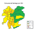
Metropolitan communes by Human Development Index
-
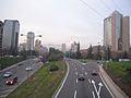
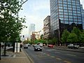
Kennedy Avenue, East Santiago with the Hyatt at the far right.
-
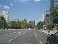
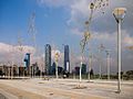
Isidora Goyenechea Avenue, Santiago financial district.
-
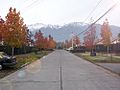
Typical middle-class neighbourhood
-
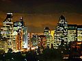
Santiago at night
-
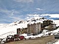
One of the region's ski centers
-
Sanhattan, Santiago's financial district with the Great Tower of Santiago.
-

Santiago's Financial District with the Great Tower on the right and the Titanium on the left.
-
Apoquindo Avenue, the main avenue leading to the financial district.
-
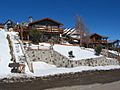
House in one of the region's ski centers.


See also
 In Spanish: Región Metropolitana de Santiago para niños
