
Santiago Province, Chile facts for kids
Quick facts for kids
Santiago Province
Provincia de Santiago
|
|
|---|---|

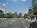
Alameda del Libertador Bernardo O'Higgins, a large boulevard in downtown Santiago.
|
|

Location in the Santiago Metropolitan Region
|
|

Santiago Province
Location in Chile
|
|
| Country | Chile |
| Region | Santiago Metropolitan |
| Capital | Maipú |
| Communes | List of 32 |
| Area | |
| • Total | 2,030.3 km2 (783.9 sq mi) |
| Area rank | 4 |
| Population
(2012 Census)
|
|
| • Total | 4,997,637 |
| • Rank | 1 |
| • Density | 2,461.53/km2 (6,375.32/sq mi) |
| Time zone | UTC−4 (CLT) |
| • Summer (DST) | UTC−3 (CLST) |
| Area code | 56 + 2 |
The Santiago Province (called Provincia de Santiago in Spanish) is one of the six provinces in the Santiago Metropolitan Region of central Chile. It is home to most of the people in that region. This includes 31 out of the 36 communities that make up Greater Santiago. The province covers an area of about 2,030 square kilometers (784 square miles).
Contents
How Santiago Province is Governed
Santiago Province is a second-level administrative division in Chile. This means it's a major area within the country. Since its capital city is also the capital of the larger region, the person in charge of the province is actually the regional delegate. This person is chosen by the country's president.
Communities of Santiago Province
The province is divided into 32 smaller areas called comunas (communities). Each comuna is managed by a local government. This government includes an alcalde (mayor) and a municipal council (a group of elected officials).
| Commune | Area (km2) | 2002 population |
Pop. density (km2) | Municipality website |
|---|---|---|---|---|
| Santiago (Capital) | 22.4 | 200,792 | 8,963.9 | link |
| Vitacura | 28.3 | 81,499 | 2,879.8 | link |
| San Ramón | 6.5 | 94,906 | 14,600.9 | link |
| San Miguel | 9.5 | 78,872 | 8,302.3 | link |
| San Joaquín | 9.7 | 97,625 | 10,064.4 | link |
| Renca | 24.2 | 133,518 | 5,517.3 | link |
| Recoleta | 16.2 | 148,220 | 9,149.4 | link |
| Quinta Normal | 12.4 | 104,012 | 8,388.1 | link |
| Quilicura | 57.5 | 126,518 | 2,200.3 | link |
| Pudahuel | 197.4 | 195,653 | 991.1 | link |
| Providencia | 14.4 | 120,874 | 8,394.0 | link |
| Peñalolén | 54.2 | 216,060 | 3,986.3 | link |
| Pedro Aguirre Cerda | 9.7 | 114,560 | 11,810.3 | link |
| Ñuñoa | 16.9 | 163,511 | 9,675.2 | link |
| Maipú | 133.0 | 468,390 | 3,521.7 | link |
| Macul | 12.9 | 112,535 | 8,723.6 | link |
| Lo Prado | 6.7 | 104,316 | 15,569.6 | link |
| Lo Espejo | 7.2 | 112,800 | 15,666.7 | link |
| Lo Barnechea | 1,023.7 | 74,749 | 73.0 | link |
| Las Condes | 99.4 | 249,893 | 2,514.0 | link |
| La Reina | 23.4 | 96,762 | 4,135.1 | link |
| La Pintana | 30.6 | 190,085 | 6,211.9 | link |
| La Granja | 10.1 | 132,520 | 13,120.8 | link |
| La Florida | 70.8 | 365,674 | 5,164.9 | link |
| La Cisterna | 10.0 | 85,118 | 8,511.8 | link |
| Independencia | 7.4 | 65,479 | 8,848.5 | link |
| Huechuraba | 44.8 | 74,070 | 1,653.3 | link |
| Estación Central | 14.1 | 130,394 | 9,247.8 | link |
| El Bosque | 14.1 | 175,594 | 12,453.5 | link |
| Conchalí | 70.7 | 133,256 | 1,884.8 | link |
| Cerro Navia | 11.1 | 148,312 | 13,361.4 | link |
| Cerrillos | 21.0 | 71,906 | 3,424.1 | link |
Climate and Natural Features

The climate in Santiago Province is a type of temperate Mediterranean climate. This means it has warm, dry summers and cool, wet winters. Rain usually falls in the winter months. Sometimes, snow can fall in the city of Santiago during colder winters, especially in areas higher than 1,000 meters (about 3,280 feet) above sea level. Winters are often cold with many frosts, where temperatures drop below 0°C (32°F).
The Coast Mountains act like a shield. They block some of the ocean's influence, making the climate more "continental." This is why Santiago gets less rain (360 mm) than a coastal city like Valparaíso (460 mm).
On average, Santiago Province receives about 367 mm (14.4 inches) of rain each year. The average yearly temperature is 13.5°C (56.3°F). The average high temperature is 21°C (69.8°F), and the average low is 6°C (42.8°F).
Most of the province is a very fertile, flat plain. Locals call this area la Depresión intermedia (the Intermediate Depression). This land is known for being low compared to sea level. It is surrounded by hills and has some "island hills" sticking up, like Santa Lucía (an old volcano) and Renca. These hills are now part of the city of Santiago.
You can also find the endangered Chilean Wine Palm (Jubaea chilensis) in Santiago Province. This special tree used to cover a much larger area in central Chile. However, its habitat has shrunk a lot because of the growing human population.
People and History

A Look at History
Before the Spanish arrived, the central part of Chile was home to a small number of native people called Picunches. They were a northern group of the Mapuche people. When Europeans took over, it greatly changed the native population and their way of life. Their culture quickly broke apart. One big reason was that the Spanish Crown gave land to its settlers. Also, a system called encomiendas was put in place. This system, which ended in the late 1700s, had lasting effects. It meant that native lands were taken, and groups of native people had to pay tribute to the Spanish. Over time, the culture in the province, and in all of Chile, became mostly European. There were only small hints of native culture left. This led to the population becoming more similar in culture.
Population Facts
Based on the 2002 census, Santiago Province had 4,668,473 residents. Of these, 2,244,497 were male and 2,423,976 were female. This means there were about 92.6 males for every 100 females. The population density here is the highest in Chile, with about 2,999 people per square kilometer. The most crowded comuna is Lo Prado, and the one with the most people is La Florida.
In 2002, almost all residents (99.79%) lived in urban areas (cities and towns). Only 9,786 people lived in rural areas (the countryside). The population grew by about 0.9% each year around 2005. The average life expectancy in Santiago Province is 80 years. This is the same as the national average for Chile, which is the highest in Latin America. Women live about 82 years, and men about 78 years. The average household income in the area was about $29,062 in PPP US dollars in 2000.
The government encourages people to live in city centers in tall buildings. This helps keep the population spread out between the city heart and the suburbs. It also helps prevent the city of Greater Santiago from spreading out too much.
Economy

Santiago Province's economy creates about 30% of Chile's total income. This is a high number because the country's capital city is located here. Also, its central location helps a lot. The "primary" sector, which includes farming, makes up less than 3.5% of the economic activity. This number has stayed about the same in the early 2000s.
The "secondary" sector, which is industry, adds 21% to the region's GDP (Gross Domestic Product). The "tertiary" or service sector makes up about 76% of the regional GDP. This province is known for its strong industry and, even more so, for its service sector. Industry here is very diverse. Along with the Valparaíso and Biobío regions, Santiago is one of Chile's three main industrial areas. Important industries in Santiago Province include machinery, electronic equipment, leather goods, food processing, chemicals, and metalworking.
The service sector is very large because of many different businesses. These include electricity, gas, water, construction, shops, transportation, communication, financial services, housing, education, health, and public administration.
Transportation and Communication
Since Santiago Province includes the city of Santiago, its road network is very important for getting around. The main roads that go from north to south are:
- Route 5 (Autopista Central)
This highway is part of the Panamerican Highway in Chile. Its "Kilometer Zero" (the starting point for measuring distances) is in Santiago Province. It's located where it crosses the Alameda del Libertador Bernardo O'Higgins. This highway is also called "Norte-Sur" (North-South). It has good pavement and two or three lanes in each direction.
- Route 68
This road connects Santiago with Valparaíso, Viña del Mar, and beach towns in the Valparaíso region. It also links to the towns of Casablanca and Curacaví. This toll highway is 115 kilometers (about 71 miles) long. It has two or three lanes and is well-maintained.
- Route 78 (Autopista del Sol)
The "Highway of the Sun" is a toll road. It connects Santiago with San Antonio. From there, it links to other coastal towns like Llolleo, Cartagena, El Quisco, and Algarrobo. It also connects to inland towns such as Melipilla, Talagante, El Monte, Padre Hurtado, and Peñaflor. Route 78 is 110 kilometers (about 68 miles) long.
- Route G-21
This 40-kilometer (about 25-mile) road connects Santiago with the winter ski resorts of Farellones and Valle Nevado.
- Route G-25
This route connects Santiago and the area of Puente Alto with Cajón del Maipo. It goes for about 70 kilometers (43 miles) until it reaches the town of El Volcán.
Roads and Railways
Other important highways in Santiago province are its network of Autopistas Urbanas (urban highways). Santiago's first toll roads started working in late 2004. To pay for these tolls, vehicles need a special electronic payment system called Televía or TAG. Cars must have these TAG devices to use the highways.
The main urban highways in Santiago province are:
- Autopista Central
- Autopista Costanera Norte
- Autopista Vespucio Norte Express
- Autopista Vespucio Sur
The province's railroads are a very important way for people to travel every day. They are run by a state company called EFE. This company provides a continuous train line between Valparaíso and Puerto Montt. The Metrotrén trains connect the outer suburbs with the capital city.
Another key way to get around the city is the Santiago Metro, which is a subway system. Its five train lines carry about one million people daily. This makes the metro one of the most important ways to travel in the whole country. In one year, the metro serves over 360 million people. Both the metro and the railroad system are considered the most modern in Latin America. The Transantiago bus system is also a major part of transportation.
Images for kids
-
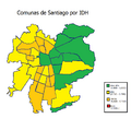
Metropolitan communes by Human Development Index
-
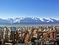
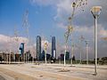
Santiago de Chile
-
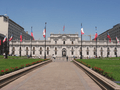
View of Palacio de La Moneda
-
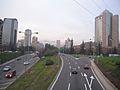
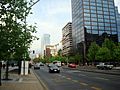
East Santiago
-
East Santiago
-
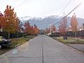
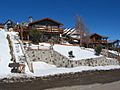
Typical middle-class neighbourhood
-
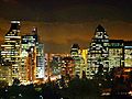
Santiago at night
-
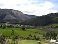
View of the region's rural part
-
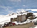
One of the region's ski centres
-
-

-
-
-

Polo national team with ex-president Michelle Bachelet after winning Polo's World Cup


See also
 In Spanish: Provincia de Santiago para niños
