
Curacaví facts for kids
Quick facts for kids
Curacaví
|
||||
|---|---|---|---|---|
 |
||||
|
||||
| Country | Chile | |||
| Region | Santiago Metropolitan Region | |||
| Province | Melipilla Province | |||
| Government | ||||
| • Type | Municipality | |||
| Area | ||||
| • Total | 693.2 km2 (267.6 sq mi) | |||
| Population
(2017 Census)
|
||||
| • Total | 34,337 | |||
| • Density | 49.534/km2 (128.293/sq mi) | |||
| • Urban | 20,360 | |||
| • Rural | 12,219 | |||
| Sex | ||||
| • Men | 18,620 | |||
| • Women | 18,859 | |||
| Time zone | UTC-4 (CLT) | |||
| • Summer (DST) | UTC-3 (CLST) | |||
| Area code(s) | 56 + | |||
| Website | [1] | |||


Curacaví is a city and a commune (a type of local government area) in central Chile. It's part of the Melipilla Province within the Santiago Metropolitan Region. The weather here is like the Mediterranean, with long, dry summers and warm temperatures, and cooler winters.
Curacaví is located along Ruta 68, a main road that connects the coastal cities of Viña del Mar and Valparaíso with Santiago. This location has made it a popular place for people who work in Santiago but want to live somewhere quieter.
The commune of Curacaví is nestled among the hills of the coastal mountain range. It covers an area of 693 square kilometers. It shares borders with several other communes, including Casablanca, Quilpué, Lampa, Pudahuel, Maipú, Padre Hurtado, Melipilla, and Maria Pinto.
Curacaví is part of a larger group of communes that form the 31st Electoral District in Chile. It also belongs to the 7th Chilean Senate District. The commune itself is divided into five smaller areas: Curacaví, Bustamante, Lo Prado, Zapata, and Caren.
Contents
Growing Communities in Curacaví
Curacaví has seen a lot of growth, especially with new gated communities called condominios. These are large, fancy developments where each property can be very big. The building of these communities started in the 1990s and has really sped up recently.
Many wealthy people from Santiago, both Chileans and foreigners, are choosing to live here. They enjoy the faster travel times to Santiago and a better quality of life, away from Santiago's pollution. Thanks to Ruta 68 and the Lo Prado tunnel, it takes only about 35 minutes to get to Santiago.
Curacaví's Geography and Climate
Curacaví is surrounded by the hills of the coastal mountain range. It covers about 693.2 square kilometers. Its neighbors include Casablanca, Quilpué, Lampa, Pudahuel, Maipú, Padre Hurtado, Melipilla, and María Pinto.
The climate is a mild Mediterranean type. This means it has a long dry season with high temperatures in the summer and lower temperatures in the winter.
| Climate data for Curacaví | |||||||||||||
|---|---|---|---|---|---|---|---|---|---|---|---|---|---|
| Month | Jan | Feb | Mar | Apr | May | Jun | Jul | Aug | Sep | Oct | Nov | Dec | Year |
| Mean daily maximum °C (°F) | 29.0 (84.2) |
28.4 (83.1) |
26.3 (79.3) |
22.8 (73.0) |
18.9 (66.0) |
15.8 (60.4) |
16.0 (60.8) |
17.3 (63.1) |
19.6 (67.3) |
22.4 (72.3) |
25.6 (78.1) |
27.9 (82.2) |
22.5 (72.5) |
| Daily mean °C (°F) | 21.5 (70.7) |
21.0 (69.8) |
19.0 (66.2) |
16.0 (60.8) |
13.4 (56.1) |
11.0 (51.8) |
10.9 (51.6) |
11.8 (53.2) |
13.8 (56.8) |
16.1 (61.0) |
18.6 (65.5) |
20.6 (69.1) |
16.1 (61.1) |
| Mean daily minimum °C (°F) | 14.1 (57.4) |
13.7 (56.7) |
11.8 (53.2) |
9.3 (48.7) |
8.0 (46.4) |
6.3 (43.3) |
5.8 (42.4) |
6.3 (43.3) |
8.0 (46.4) |
9.8 (49.6) |
11.7 (53.1) |
13.3 (55.9) |
9.8 (49.7) |
| Average precipitation mm (inches) | 1 (0.0) |
7 (0.3) |
5 (0.2) |
12 (0.5) |
78 (3.1) |
111 (4.4) |
84 (3.3) |
72 (2.8) |
22 (0.9) |
15 (0.6) |
7 (0.3) |
3 (0.1) |
417 (16.5) |
| Source: Climate-Data.org | |||||||||||||
Population and People
According to the 2002 census (a count of the population), Curacaví had 24,298 people living there. This included 12,351 men and 11,947 women. Most of the people (64.4%) lived in urban areas (cities and towns), while 35.6% lived in rural areas (the countryside). Between 1992 and 2002, the population grew by 27.5%. Curacaví is also home to a quickly growing community of people from other countries.
Famous People from Curacaví
- Juan Williams Rebolledo – He was the leader of the Chilean Navy when the War of the Pacific began.
- Rosamel del Valle – An Avant-garde poet, known for his unique and experimental writing style.
How Curacaví is Governed
As a commune, Curacaví is managed by a municipal council. This council is led by an alcalde (mayor), who is chosen by the people every four years. The alcalde from 2012 to 2016 was Juan Pablo Barros Basso. The council members help make decisions for the commune.
Curacaví is part of the 31st electoral district for the Chamber of Deputies (one part of Chile's parliament). It is also part of the 7th senatorial constituency for the Senate.
Curacaví Airport

Curacaví has a small airport located right next to the Ruta 68 motorway.
Chicha Production
Curacaví is well-known in Chile for making chicha, a traditional alcoholic drink. There's even a popular Chilean folk song called cueca titled "Chicha de Curacaví"!
Historic Road to Valparaíso
Curacaví is located on a very old horse trail that connected Valparaíso and Santiago. This path was used even during the Inca period. By 1553, it was known as the "royal highway." The original royal highway was built between 1792 and 1797. However, Ambrosio O'Higgins later changed the route to what is now the Lo Prado road.
Mercedes Canal
The Mercedes Canal (in Spanish, Canal de las Mercedes) helps water the entire valley of Curacaví. It was built by Jose Manuel Balmaceda before he became president of Chile. The canal project started in 1854 and took 30 years to finish. It is 120 kilometers long and can carry a lot of water.
Parish School
The first Parish School in Curacaví was built in 1885 by a priest named Don Eduardo Miles. This school is still open today and has been educating many local children for a very long time.
Images for kids
-
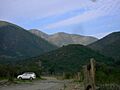
Ford of the Puangue River at Alhué near Curacaví.
-
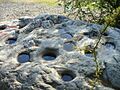
"Tacitas" (cupules) on a boulder at the banks of the Puangue River.
-
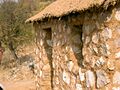
A house at the museum Museo de la Vivienda Tradicional Rural Unifamiliar Chilena.


See also
 In Spanish: Curacaví para niños
