Villarrica (volcano) facts for kids
Quick facts for kids Villarrica Volcano |
|
|---|---|

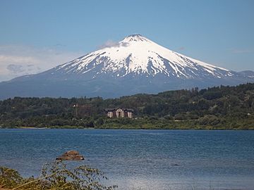
View of Villarrica Lake and the volcano
|
|
| Highest point | |
| Elevation | 2,860 m (9,380 ft) |
| Prominence | 1,575 m (5,167 ft) |
| Naming | |
| English translation | Place of Wealth |
| Language of name | Spanish |
Villarrica is one of Chile's most active volcanoes. It stands tall over Villarrica Lake and the town of Villarrica. This volcano is about 750 km (466 mi) south of Santiago, Chile's capital city.
People also call it Rucapillán. This name comes from the Mapuche language. It means "great spirit's house". Villarrica is part of a group of three large stratovolcanoes. These volcanoes are protected inside Villarrica National Park. Many people enjoy guided climbs to the top during the summer.
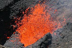
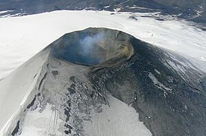
Villarrica is special because it has an active lava lake inside its crater. This lava lake sometimes glows brightly. The volcano often has small eruptions called strombolian eruptions. These eruptions throw out hot rocks and lava. When it rains or snow melts, it can mix with ash. This creates huge mudflows called lahars. This happened during eruptions in 1964 and 1971.
Villarrica is one of nine volcanoes watched by the Deep Earth Carbon Degassing Project. This project collects information. It measures how much carbon dioxide and sulphur dioxide gas volcanoes release.
Contents
Exploring Villarrica's Geography
Villarrica volcano is located just east of the Chilean Central Valley. It is the most western volcano in a line of three large stratovolcanoes. Scientists believe this line of volcanoes formed because of an old crack in the Earth's crust. This crack is called the Mocha-Villarrica Fault Zone. The other volcanoes in this line are Quetrupillán and Lanín. They are not as active as Villarrica. This line of volcanoes is unusual. It crosses another fault line called the Liquiñe-Ofqui Fault. Many active volcanoes are found along that fault.
Villarrica covers a large area of about 400 square kilometers. Its total volume is estimated to be 250 cubic kilometers. The volcano has many interesting features. It contains volcanic caves and about 26 small scoria cones. The constant release of gas from the lava lake makes the lava thicker. This can make its eruptions more explosive. There are also two large layers of volcanic rock called ignimbrites. These are the Licán Ignimbrite and the Pucón Ignimbrite.
Villarrica's Glaciers and Ice
The top part of Villarrica volcano is always covered in snow. It also has about 40 square kilometers of glaciers. The biggest glacier is the Pichillancahue-Turbio Glacier. It is on the volcano's southeastern side. Ash from eruptions can make snow and ice melt faster. This happens because the ash absorbs sunlight. However, if the ash layer is thicker than 5 centimeters, it can actually protect the glacier. It acts like an insulating blanket, slowing down the melting. Between 1961 and 2003, Villarrica lost a quarter of its glaciated area. The glaciers shrunk by about 0.4 square kilometers each year.
Fun Activities and Tourism
Villarrica is a very popular place for climbing. Many people take guided trips to the crater from the town of Pucón. However, these trips might be stopped if the weather is bad or if the volcano is too active. Since 2007, you can even take helicopter rides over the volcano! In the winter, from July to September, there is a ski resort on the northern slopes.
The youngest person to reach the summit was Christopher Heussner. He was a child from Texas. He climbed to the top in 1999 when he was just 9 years old. The Chilean government recognized his achievement.
Villarrica's Eruptive History
Villarrica is one of Chile's most active volcanoes. People have recorded its eruptions since the conquest of Chile. The city of Villarrica was founded in 1552. It was first built near where Pucón is today. The volcano had many small eruptions in the late 1500s. The biggest eruptions happened in 1558 and 1562. The 1562 eruption spread thin layers of ash up to 200 km (124 mi) away.
In its early years, the city of Villarrica was important for gold and silver mining. But mining slowly decreased. It is thought that mudflows from the mid-1500s eruptions covered the gold deposits. This might have made settlers move the city westward. They moved it to its current location, which was safer from volcanic dangers. It is hard to know about eruptions in the early 1600s. This was because of the Mapuche and Huilliche uprising. Many Spanish settlements were abandoned during this time.
Eruptions of 1963 and 1964
The volcano became active again on March 8, 1963. On March 12, lava started flowing from a new opening on the side of the volcano. This opening was about 250 meters (820 ft) below the top. The lava flow was 1000 meters (3280 ft) long and 150 meters (492 ft) wide. It stopped flowing by March 19. At the same time, the main crater continued its small eruptions. More explosive eruptions began on May 2, 1963. The eruption became a steady flow of lava by May 21. The last effects of this eruption cycle were mudflows. These mudflows ran down the volcano on May 24.
In late February 1964, Villarrica had small, strong lava flows and tremors. On March 2, at 2:45 am, it started a strombolian eruption. People in Coñaripe, a town that cut wood, ran to the nearby hills.
Later, the people of Coñaripe decided to go back to their homes. They wanted to find shelter from heavy rain. At midnight, a new lava flow moved downhill. It melted snow and ice. This caused five mudflows. The melting snow and ice from the Pichillancahue-Turbio Glacier mixed with heavy rain. This created several large mudflows.
One of these mudflows surprised the people of Coñaripe. It swept over the town and sadly killed 27 people. The small village of Chaillupén was also destroyed by a mudflow. Thirty houses were lost there, but no one died. Other mudflows flowed north. They destroyed several bridges between Villarrica and Pucón. Then they flowed into Villarrica Lake. The sudden rush of mudflows into the lake made the water level rise. This flooded some low-lying fields.
Some Mapuche people blamed settlers for the disaster. They believed the settlers had cursed Coñaripe. This idea showed their belief that nature was "allied with the Indians."
1971–1972 Eruption
On October 29, 1971, at 3:00 am, there were several explosions in the crater. A column of white, then black, smoke appeared. One month later, on November 29, Villarrica started a new eruption cycle. Hot rocks were thrown out. The snow around the crater melted. After a short stop, lava poured from a new opening on the northeast side. This melted a lot of water. It caused more mudflows. These mudflows affected several places. These included Pichaye, El Turbio, Collentañe, Minetué, Molco, Voipir, and Curarrehue. All these places are in the Trancura River basin. Dangerous sulphurous gases made the air hard to breathe in Villarrica and Pucón. At least 15 deaths were reported there.
2015 Eruption
On February 7, 2015, Villarrica caused a yellow alert. This alert was issued by both Servicio Nacional de Geología y Minería and Onemi. Small explosions and low amounts of ash were seen. Ten days later, another eruption happened. The National Service of Geology and Mining (Sernageomin) declared a yellow alert again. This was because volcanic and earthquake activity increased. The National Emergency Office (ONEMI) kept the yellow alert.
Around 3:01 AM on March 3, 2015, the volcano erupted. The alert level was raised to red for areas up to 10 kilometers (6.2 mi) around the volcano. The eruption was taller than the volcano itself. It caused a loud explosion that woke people nearby. About 3,385 people in nearby towns had to leave their homes.
The Southern Andean Volcano Observatory (OVDAS) said that a new eruption would continue. This was expected until 12:30 PM on March 19, 2015. The eruption was still going on in July 2015. Scientists measure the gases coming from this volcano. They use a special system called a Multi-Component Gas Analyzer System. This helps them detect gases released before an eruption. This helps them better predict volcanic activity.
See also
In Spanish: Volcán Villarrica para niños
 | Georgia Louise Harris Brown |
 | Julian Abele |
 | Norma Merrick Sklarek |
 | William Sidney Pittman |


