Curarrehue facts for kids
Quick facts for kids
Curarrehue
|
||||
|---|---|---|---|---|
|
Town and commune
|
||||

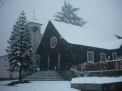
View of Curarrehue's church a winter day
|
||||
|
||||
| Country | Chile | |||
| Region | Araucanía | |||
| Province | Cautín | |||
| Founded | 1981 | |||
| Government | ||||
| • Type | Municipality | |||
| Area | ||||
| • Total | 1,170.7 km2 (452.0 sq mi) | |||
| Elevation | 406 m (1,332 ft) | |||
| Population
(2012 census)
|
||||
| • Total | 6,624 | |||
| • Density | 5.6582/km2 (14.6545/sq mi) | |||
| • Urban | 1,862 | |||
| • Rural | 4,922 | |||
| Sex | ||||
| • Men | 3,586 | |||
| • Women | 3,198 | |||
| Area code(s) | (+56) 45 | |||
Curarrehue (pronounced ku-ra-RE-we) is a small town and commune located in the Cautín Province of the Araucanía Region in Chile. It's a place with a rich history, especially connected to the Mapuches, who are the native people of this area.
The town of Curarrehue began to form in the late 1800s. During that time, the Mapuches were moving into this valley. They settled here after being pushed through the Mamuil Malal Pass by armies from Argentina and Chile.
Besides the main town, the Curarrehue commune also includes the village of Catripulli. In 2017, about 424 people lived in Catripulli. The town of Curarrehue is built on a geological feature called the Reigolil-Pirihueico Fault.
Contents
People and Population
Curarrehue is home to many people. According to a census taken in 2002, the area of Curarrehue covers about 1,170.7 square kilometers (about 452 square miles). At that time, 6,784 people lived there.
- Out of these, 3,586 were men and 3,198 were women.
- About 1,862 people (27.4%) lived in the main town area.
- The majority, 4,922 people (72.6%), lived in the surrounding rural areas.
Between 1992 and 2002, the population of Curarrehue grew by 13.5%, which means 806 more people came to live there.
How the Town is Run
Curarrehue is a commune, which is like a local government area in Chile. It's managed by a municipal council. The leader of this council is called an alcalde, who is similar to a mayor. The alcalde is chosen directly by the people in an election every four years.
The alcalde for the 2008-2012 period was Héctor Carrasco Ruiz. The current alcalde is Abel Painefilo Barriga.
Representing Curarrehue
Curarrehue is part of larger areas for voting in Chile.
- For the Chamber of Deputies, which is like one part of the country's parliament, Curarrehue is in the 52nd electoral district. This district also includes towns like Cunco, Pucón, and Villarrica.
- For the Senate, which is the other part of the parliament, Curarrehue is in the 15th senatorial area, known as Araucanía-South.
Weather and Nature
Curarrehue has a cool and wet oceanic climate. This means it gets a lot of rain, especially in winter. The average rainfall each year is about 2,134 millimeters (84 inches).
- Summers are mild during the day and cool at night.
- Winters are chilly and much wetter, and it often snows.
This type of weather is known as a Cfb climate according to the Köppen climate classification system.
| Climate data for Curarrehue | |||||||||||||
|---|---|---|---|---|---|---|---|---|---|---|---|---|---|
| Month | Jan | Feb | Mar | Apr | May | Jun | Jul | Aug | Sep | Oct | Nov | Dec | Year |
| Mean daily maximum °C (°F) | 20.6 (69.1) |
20.9 (69.6) |
18.0 (64.4) |
13.4 (56.1) |
9.6 (49.3) |
5.5 (41.9) |
4.5 (40.1) |
5.4 (41.7) |
8.1 (46.6) |
11.3 (52.3) |
14.8 (58.6) |
17.8 (64.0) |
12.5 (54.5) |
| Daily mean °C (°F) | 14.8 (58.6) |
14.9 (58.8) |
12.3 (54.1) |
8.6 (47.5) |
5.5 (41.9) |
2.4 (36.3) |
1.3 (34.3) |
2.0 (35.6) |
3.6 (38.5) |
6.3 (43.3) |
9.5 (49.1) |
12.3 (54.1) |
7.8 (46.0) |
| Mean daily minimum °C (°F) | 9.3 (48.7) |
9.6 (49.3) |
7.6 (45.7) |
4.7 (40.5) |
2.5 (36.5) |
0.1 (32.2) |
−1.1 (30.0) |
−0.6 (30.9) |
0.1 (32.2) |
2.0 (35.6) |
4.7 (40.5) |
7.2 (45.0) |
3.8 (38.9) |
| Average precipitation mm (inches) | 61 (2.4) |
59 (2.3) |
81 (3.2) |
153 (6.0) |
249 (9.8) |
380 (15.0) |
311 (12.2) |
292 (11.5) |
176 (6.9) |
154 (6.1) |
117 (4.6) |
101 (4.0) |
2,134 (84) |
| Source: Climate-data.org | |||||||||||||
See also
 In Spanish: Curarrehue para niños
 | Jessica Watkins |
 | Robert Henry Lawrence Jr. |
 | Mae Jemison |
 | Sian Proctor |
 | Guion Bluford |


