King Edward Cove facts for kids
Quick facts for kids King Edward Cove |
|
|---|---|

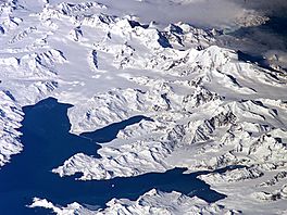
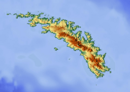
Central South Georgia: Cumberland Bay; Thatcher Peninsula with King Edward Cove (Grytviken); Allardyce Range with the summit Mount Paget (NASA imagery).
|
|
| Coordinates | 54°17′S 36°30′W / 54.283°S 36.500°W |
King Edward Cove (which is Caleta Capitán Vago in Spanish) is a safe, quiet bay. It is located on the west side of Cumberland East Bay in South Georgia.
Long ago, seal hunters often visited this area. The Swedish Antarctic Expedition, from 1901 to 1904, mapped this cove. The expedition was led by Otto Nordenskiöld. They named it Grytviken, which means 'Pot Bay'. This name was later used for the whaling station and settlement built there in 1904. Around 1906, the cove was renamed King Edward Cove. This was in honor of King Edward VII of the United Kingdom.
Today, the British Antarctic Survey has a research station called King Edward Point. It is on Hope Point, which is the northernmost tip of the cove. The old whaling station, Grytviken, is on the western shore of the cove.
Contents
Exploring King Edward Cove
This section tells you about some important places around King Edward Cove.
Hope Point
Hope Point is a rocky cliff that is about 20 meters (66 feet) high. It forms the northern side of the entrance to King Edward Cove. People from the Swedish Antarctic Expedition named it. They named it after H.W.W. Hope. He led a survey of King Edward Cove in 1920. This survey was done by people on the ship HMS Dartmouth. Hope Point also has a monument. It remembers Sir Ernest Shackleton, a famous explorer.
Nearby Mountains and Lakes
King Edward Cove is located southwest of a place called Mount Duse. It is also southeast of Mount Hodges. Both of these are part of the Thatcher Peninsula. Close to the southwest shore of the cove, you can find Gull Lake.
Hobart Rock and Susa Point
Hobart Rock is a low rock found at the southern side of the cove's entrance. Its name appeared on a map made in 1906. This map was based on a survey by people on the ship HMS Sappho.
Just a short distance, about 0.4 kilometers (0.25 miles), south of King Edward Cove is Susa Point. This is a low, rocky area. It marks the end of a small ridge that separates two flat, grassy areas. The Swedish Antarctic Expedition first surveyed Susa Point. Later, in 1951, the Falkland Islands Dependencies Survey (FIDS) named it. The name Susa comes from a group of names in the area. These names are related to the chemical fixatives used by FIDS for their biological research.
See also
 In Spanish: Caleta Vago para niños
 | Emma Amos |
 | Edward Mitchell Bannister |
 | Larry D. Alexander |
 | Ernie Barnes |


