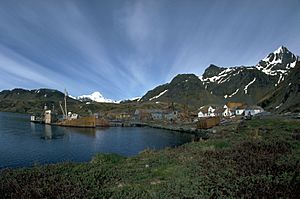
Cumberland East Bay facts for kids
Cumberland East Bay is a large bay located on the island of South Georgia. It's like an arm stretching out from the bigger Cumberland Bay. This bay is found between two points of land: Sappho Point and Barff Point. It's about 3 miles (4.8 km) wide and reaches about 8 miles (12.9 km) into the land towards the southeast.
Contents
Exploring the History of Cumberland East Bay
This section tells you how Cumberland East Bay got its name and about an important event that happened there.
How Cumberland East Bay Got Its Name
The bay was first explored and mapped by the Swedish Antarctic Expedition between 1901 and 1904. They originally called it "South Bay." Later, from 1926 to 1929, a group called Discovery Investigations re-mapped the area. They decided to rename it "East Cumberland Bay" because it better described its location. Sometimes, people just called it "East Bay."
After the South Georgia Survey in 1951–52, the UK Antarctic Place-Names Committee suggested changing the name again to "Cumberland East Bay." This new name helps keep all information about the larger Cumberland Bay together. It also prevents confusion with another place called East Bay in Prince Olav Harbour, which is also on South Georgia.
A Difficult Journey During the Falklands War
In 1982, a conflict known as the Falklands War took place. From April 22 to April 24, a special British military team called the Special Boat Service tried to cross Cumberland East Bay. They had landed in Hound Bay and traveled through the Sörling Valley. However, they faced very harsh weather with lots of ice and snow. Because of these difficult conditions, they couldn't reach their goal of attacking certain positions.
Important Places in Cumberland East Bay
Many parts of Cumberland East Bay have been mapped and named by different groups exploring the Antarctic.
Western Coast Features
The western side of the bay starts with Sappho Point. Moving south along this coast, you'll find King Edward Cove, which is about 2.5 miles (4 km) southwest. Further south, a flat area of land called Hestesletten stretches from inland all the way to the coast. Moraine Fjord is at the very end of the western part of the bay, separated by Greene Peninsula. The Nordenskjöld Glacier also flows into the main part of Cumberland East Bay.
Eastern Coast Features
The eastern side of the bay is formed by Barff Peninsula, ending at Barff Point in the north. Along this coast, there's a small inlet called Sandebugten. This cove is at the western end of Reindeer Valley. The name "Sandebugten" was first seen on a British map from 1929. It was likely given by Norwegian whalers who used to work in South Georgia.
See also
 In Spanish: Bahía Cumberland Este para niños
 | Calvin Brent |
 | Walter T. Bailey |
 | Martha Cassell Thompson |
 | Alberta Jeannette Cassell |


