Mount Roots facts for kids
| Mount Roots | |
|---|---|
| Elevation: | 2,270 metres (7,447 feet) |
| Coordinates: | 54°28′S 36°24′W / 54.467°S 36.400°W |
| Location: | South Georgia |
| Range: | Allardyce Range |
| First ascent: | January 2001 |
| Easiest route: | snow/ice climb |
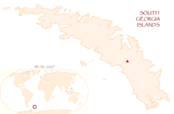
Mount Roots is a tall mountain covered mostly in snow. It's located on South Georgia, which is a remote island in the southern Atlantic Ocean. This mountain stands close to the start of the Nordenskjöld Glacier, about 6 kilometers (3.7 miles) southeast of Mount Paget.
Mount Roots has two main peaks. Its western peak reaches a height of 2,158 meters (7,080 feet), while its eastern peak is even taller at 2,270 meters (7,447 feet). This makes it the fifth-highest mountain on the island. It's a very noticeable landmark, and people like whalers and sealers probably knew about it a long time ago.
Exploring and Naming Mount Roots
Scientists and explorers first roughly mapped Mount Roots between 1925 and 1930. Later, a group called the South Georgia Survey (SGS) did a more detailed survey in 1951 and 1952.
The mountain was named by the UK-APC (United Kingdom Antarctic Place-names Committee). They named it after James W. Roots, who was a member of the SGS team during their survey in the early 1950s.
First Climbers to the Top
The very first time anyone successfully climbed Mount Roots was in January 2001. Two British climbers, Will Manners and Stuart Macdonald, made the challenging climb up the mountain's north side.
See also

- In Spanish: Monte Roots para niños
 | Aaron Henry |
 | T. R. M. Howard |
 | Jesse Jackson |


