South Orkney Islands facts for kids

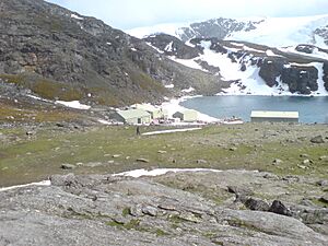
Signy Island base and panorama
|
|
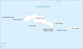
Map of the South Orkney Islands
|
|
| Geography | |
|---|---|
| Area | 620 km2 (240 sq mi) |
| Highest elevation | 4,153 ft (1,265.8 m) |
| Administration | |
|
Administered under the Antarctic Treaty System
|
|
| Demographics | |
| Population | approx. 53-55 (Summer) 14 (Winter) |
The South Orkney Islands are a group of islands in the Southern Ocean. They are about 604 kilometres (375 mi) north-east of the Antarctic Peninsula. These islands cover a total area of about 620 square kilometres (240 sq mi). Both Britain and Argentina claim these islands. However, under the 1959 Antarctic Treaty, these claims are put aside. This means countries agree to use the area for peaceful, scientific purposes only.
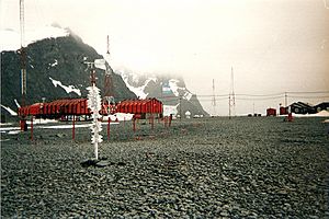
Both Britain and Argentina have research bases on the islands. Argentina's base, Orcadas, started in 1904 on Laurie Island. It can house up to 45 people in summer and about 14 in winter. The British Antarctic Survey has the Signy Research Station on Signy Island. It was built in 1947. This base is now open only during the southern hemisphere summer, from November to April. Other than the people working at these bases, no one lives on the islands permanently.
Contents
Discovering the South Orkney Islands
The South Orkney Islands were first seen in 1821. Two sealers, Nathaniel Brown Palmer from America and George Powell from Britain, discovered them. At first, they were called Powell's Group. The main island was named Coronation Island because it was the year King George IV was crowned.
In 1823, a man named James Weddell visited the islands. He gave them their current name, the South Orkney Islands. This name comes from the Orkney Islands in the north of Scotland. The South Orkney Islands are at about the same latitude south as the Orkney Islands are north.
Early Visitors and Research
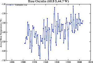
After their discovery, sealers and whalers often visited the islands. But no one fully explored them until 1903. That year, William Speirs Bruce arrived on his ship, the Scotia. He spent the winter on Laurie Island. Bruce mapped the islands and set up a weather station. When he left in 1904, he sold this station to the Argentine Government.
This base, now called Orcadas, is still working today[update]. It is the oldest research station in the Antarctic that has been used without a break.
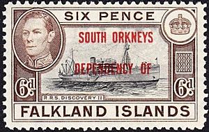
In 1908, the United Kingdom claimed the South Orkney Islands. They became part of the Falkland Islands Dependencies. Later, in 1947, the British Antarctic Survey built a research station on Signy Island. This station was used all year until 1996. Now, it's only open during the summer months. In 1962, the islands became part of the new British Antarctic Territory. Argentina also claims the islands. Their claim started in 1925 because they had a base on Laurie Island.
Geography and Climate of the Islands
The South Orkney Islands are located in the Southern Ocean. The group of islands is found at about 60°35′S 045°30′W / 60.583°S 45.500°W.
There are four main islands in this group. Coronation Island is the biggest, about 30 miles (48 km) long. Its highest point is Mount Nivea, which is 4,153 feet (1,266 m) tall. Laurie Island is the most eastern island. The other main islands are Powell and Signy. There are also smaller islands like Robertson Islands and the Saddle Islands. About 90 percent of the islands are covered in ice.
The Inaccessible Islands, about 15 nmi (17 mi; 28 km) to the west, are also considered part of the South Orkneys.
The weather in the South Orkneys is usually cold, wet, and windy. Summers are short and cold, from December to March. Average summer temperatures are around 3.5 °C (38.3 °F). In July, temperatures drop to about −12.8 °C (9 °F). The coldest it has ever been is −44 °C (−47.2 °F), and the warmest is 12 °C (53.6 °F). The seas around the islands are covered in ice from late April to November.
Plants and Animals of the South Orkneys
Even with the harsh weather, the islands have some plants and animals. They are part of the Scotia Sea Islands tundra ecoregion. This area includes other islands like South Georgia and the South Sandwich Islands and the South Shetland Islands. These islands are in the cold waters below the Antarctic convergence.
Here, you can find mosses, lichens, and algae. Many seabirds, penguins, and seals live and feed in the waters around the islands.
Close to the shore, there isn't much life. You might find amphipods and planarians under rocks, along with different types of algae, chitons, and some snails. As the water gets deeper, there is more variety of life. Starfish appear beyond 2–3 meters, along with sponges and sea urchins. Below 30 meters, there are huge groups of starfish. Two types of penguins, Chinstrap (Pygoscelis antarctica) and Adélie (Pygoscelis adeliae), live on the land.
Research Stations on the Islands
The two countries that claim the islands have research stations there:
 Argentina Orcadas Base, on Laurie Island. This station has been active since 1904. It was bought from Scottish scientist William Speirs Bruce.
 United Kingdom Signy Research Station, on Signy Island. This station has been active since 1947.
See also
 In Spanish: Islas Orcadas del Sur para niños
 | Victor J. Glover |
 | Yvonne Cagle |
 | Jeanette Epps |
 | Bernard A. Harris Jr. |


