Coronation Island facts for kids

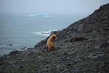
Leucistic Antarctic fur seal on Coronation Island
|
|
|
Location in Antarctica
|
|
| Geography | |
|---|---|
| Location | Antarctica |
| Coordinates | 60°37′S 45°35′W / 60.617°S 45.583°W |
| Archipelago | South Orkney Islands |
| Area | 450 km2 (170 sq mi) |
| Length | 46 km (28.6 mi) |
| Width | 5.6–14.8 km (3.5–9.2 mi) |
| Highest elevation | 1,265 m (4,150 ft) |
| Highest point | Mount Nivea |
| Administration | |
| Administered under the Antarctic Treaty System | |
| Demographics | |
| Population | 0 |
Coronation Island is the biggest island in the South Orkney Islands. It is about 46 kilometers (25 miles) long. It is also between 5.6 and 14.8 kilometers (3 to 8 miles) wide. The island mostly stretches from east to west. It is covered in ice and has many bays, glaciers, and tall mountains. The highest peak reaches 1,265 meters (4,150 feet) high.
Island History
Coronation Island was found in December 1821. Two seal hunters, Captain Nathaniel Palmer from America and Captain George Powell from Britain, discovered it together. Captain Powell named the island to honor the crowning of George IV. He had become the king of the United Kingdom in 1820.
Special Protected Area
A large part of north-central Coronation Island is a special protected area. It is called an Antarctic Specially Protected Area (ASPA 114). This area is about 92 square kilometers (35.5 square miles). It is kept very natural and untouched. Scientists use it to compare with other places that have been changed more by humans.
This protected area goes north from Brisbane Heights and Wave Peak. These are mountains in the center of the island. It reaches the coast between Conception Point in the west and Foul Point in the east. Most of this land is covered by glaciers. But there are small areas along the coast that are free of ice. Many birds live and have their babies here. These include chinstrap penguins, Cape petrels, and snow petrels.
Island Features
Many places on and around Coronation Island have been mapped and named. Different groups of explorers and surveyors have done this work.
The northwest tip of the island is called Penguin Point. There are also several named rock formations in the sea just west of Penguin Point. These include the Melsom Rocks, the Despair Rocks, and Lay-brother Rock.
Bays
The island's coast is not smooth. It has many bays that cut into the land.
- Iceberg Bay is on the south coast. It is located between Cape Hansen and Olivine Point.
- Ommanney Bay is on the north coast. It is found between Prong Point and Foul Point.
- Sandefjord Bay is on the west coast. It is near Monroe Island.
Other Features
- Cockscomb Buttress
- Endurance Ridge
- Norway Bight
See also
 In Spanish: Isla Coronación para niños
 | Leon Lynch |
 | Milton P. Webster |
 | Ferdinand Smith |


