
Ascension Island facts for kids
Quick facts for kids
Ascension Island
|
|||
|---|---|---|---|
|
Overseas territory of the UK
|
|||

The island viewed from atop Green Mountain.
|
|||
|
|||
| Anthem: God Save the Queen | |||

Location of Ascension Island in the Atlantic Ocean.
|
|||
| Country | |||
| Overseas territory | Saint Helena, Ascension and Tristan da Cunha | ||
| Island | Ascension | ||
| Capital | Georgetown | ||
| First inhabited | 1815 | ||
| Current constitution | 2009 | ||
| Named for | Ascension Day | ||
| Government | |||
| • Type | Monarchy | ||
| Area | |||
| • Total | 88 km2 (34 sq mi) | ||
| Highest elevation | 859 m (2,818 ft) | ||
| Lowest elevation | 0 m (0 ft) | ||
| Population | |||
| • Estimate
(2010)
|
880 | ||
| • Density | 10/km2 (30/sq mi) | ||
| Time zone | UTC+0 (GMT) | ||
| Area code(s) | +247 | ||
| Internet TLD | .ac | ||
| Currency | Saint Helena pound (SHP) (US$ accepted) |
||
| Website | www.ascension-island.gov.ac | ||

.svg)
Ascension Island is a small, volcanic island in the South Atlantic Ocean. It is about 100 kilometers (62 miles) west of the mid-Atlantic Ridge. The island is quite far from other land, for example, 1,504 kilometers (935 miles) from Liberia and 2,232 kilometers (1,387 miles) from Brazil. The closest land is Saint Helena, which is 1,296 kilometers (805 miles) to the southeast.
The island got its name because it was discovered on Ascension Day. It is part of a larger area called the British Overseas Territory of Saint Helena, Ascension and Tristan da Cunha. Saint Helena is the main island in this group.
Ascension Island is home to a Royal Air Force base and a United States Air Force presence. It also has a European Space Agency station and the BBC World Service Atlantic Relay Station. One of the five antennas that help the Global Positioning System (GPS) work is located here. The other antennas are on Kwajalein Island, Diego Garcia, Colorado Springs, and Hawaii.
History of Ascension Island
Early Discoveries and Naming
The island was first seen in 1501 by a Spanish explorer named João da Nova, who was working for Portugal. He called it ilha da Conceição (Conception Island). Later, in 1503, another Portuguese sailor, Afonso de Albuquerque, saw the island on Ascension Day. He then named it after this important church holiday.
British Settlement and Napoleon
People started living on Ascension Island in 1815. The British sent soldiers there to keep an eye on Napoleon I, who was imprisoned on Saint Helena to the southeast. This was a way to make sure he couldn't escape.
Charles Darwin's Visit
In 1836, the famous scientist Charles Darwin visited Ascension Island during his journey on the ship Beagle. He described the island as very dry and without many trees, especially near the coast. Inland, there was some plant life that supported animals like sheep, goats, cows, and horses. He also saw many guineafowl (a type of bird) that had been brought from the Cape Verde islands, along with rats, mice, and land crabs.
Making the Island Green
In 1843, a botanist (plant scientist) named Joseph Hooker visited the island. Four years later, he suggested a plan to the Royal Navy. He thought they should bring trees to Ascension Island with help from Kew Gardens in London. So, starting in 1850, ships brought different plants from botanical gardens in places like Argentina, Europe, and South Africa every year. By the late 1870s, trees like Norfolk pines, eucalyptus, bamboo, and banana trees were growing on the highest part of the island, Green Mountain. This created a tropical forest that was often covered in clouds.
Modern Connections and Government
In 1899, the Eastern Telegraph Company (which is now part of Vodafone) laid the first underwater cable from the island. This cable connected the UK with its colonies in South Africa. In 1922, Ascension Island became a dependency of Saint Helena. This meant it was managed by the head of the Eastern Telegraph Company on the island until 1964. After that, the British Government appointed an Administrator to represent the Governor of Saint Helena on Ascension.
In 1981, the British government changed the status of Saint Helena and other areas to "British Dependent Territories." Then, in 2009, Saint Helena and its two territories were given equal status under a new constitution. The whole area was renamed Saint Helena, Ascension and Tristan da Cunha.
Geography

Island Shape and Size
Ascension Island is roughly shaped like a triangle. It is about 13 kilometers (8 miles) wide and covers an area of 88 square kilometers (34 square miles). It has about 100 kilometers (62 miles) of coastline. The west and north-west sides of the island have sandy beaches. However, the south and southeast coasts have steep cliffs.
Mountains and Islets
The highest point on the island is Green Mountain, also known as The Peak. It is 859 meters (2,818 feet) high. Other tall mountains include Weather Post (680 m or 1,995 ft), White Hill (525 m or 1,722 ft), and Sisters Peak (445 m or 1,460 ft).
There are also several small islands, called islets, and rocks around Ascension Island. The largest of these is Boatswainbird Island, which is about 305 meters (1,000 feet) north of the eastern part of the main island.
Climate
Ascension Island has a tropical climate, but it is also affected by the ocean. This means the weather doesn't change much throughout the year. The island is in the path of the South-East Trade Winds, so winds from the southeast and east blow for more than half of every month.
The temperature stays fairly steady all year. The average highest temperatures near the sea are between 27 °C (81 °F) and 31 °C (88 °F). Up on Green Mountain, at 660 meters (2,165 feet) high, the highest temperatures are usually about 13 °C (23 °F) cooler. The air near the sea is usually around 70% humid.
The average temperature for the year in Georgetown is 25.6 °C (78.0 °F). The warmest month is usually March, with an average temperature of 27.8 °C (82.0 °F). The coolest month is typically August, with an average temperature of 24.4 °C (76.0 °F).
| Climate data for Georgetown, Ascension Island | |||||||||||||
|---|---|---|---|---|---|---|---|---|---|---|---|---|---|
| Month | Jan | Feb | Mar | Apr | May | Jun | Jul | Aug | Sep | Oct | Nov | Dec | Year |
| Mean daily maximum °C (°F) | 27 (81) |
28 (82) |
29 (84) |
29 (84) |
28 (82) |
27 (81) |
26 (79) |
26 (79) |
26 (79) |
26 (79) |
26 (79) |
27 (81) |
27 (81) |
| Mean daily minimum °C (°F) | 23 (73) |
25 (77) |
25 (77) |
25 (77) |
25 (77) |
23 (73) |
23 (73) |
22 (72) |
22 (72) |
22 (72) |
22 (72) |
23 (73) |
23 (74) |
| Source: Weatherbase.com [1] | |||||||||||||
Demographics

Population and Settlements
About 1,000 people live on Ascension Island. Most of them are civilians who work for the RAF (British Air Force) and the USAF (American Air Force). There are also a small number of military people. These residents are mainly from the UK, USA, and Saint Helena. No one lives on the island permanently.
There are five main places where people live:
- Georgetown is the main town and the capital of the island.
- Two Boats is a village for civilians, and it has the island's only school.
- Cat Hill is the main base for the United States on the island.
- Traveller's Hill is a base for the Royal Air Force.
- Wideawake Airfield is where the Royal Air Force station is located.
Two Boats School is the only school on Ascension Island. It provides education for all children living on the island, from 3½ to 16 years old.
Gallery
-
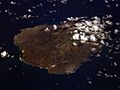
Ascension Island seen from space.
-
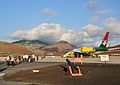
Wideawake Airfield, an important air base.
-
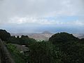
Georgetown from atop Green Mountain.
-
Ascension Government House.
-
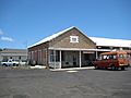
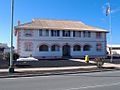
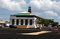
The island's post office in Georgetown.
-
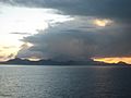
Ascension Island from the south.
-
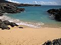
Comfortless Cove, a quiet beach.
-
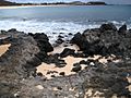
Black volcanic rocks on the island.

.JPG)


Images for kids
-
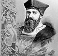
Portuguese-Galician navigator João da Nova discovered the island on Ascension Day 1501, naming it Ilha da Ascensão .
-
Royal Marine barracks (1830) in the former Royal Dockyard, Georgetown
-
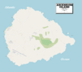
An enlargeable, detailed map of Ascension Island
-
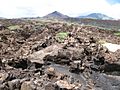
Lava fields
-
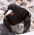
Male frigatebird with chick on Boatswain Bird Island
-
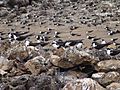
A few of the 130,000 Atlantic sooty terns at Mars Bay breeding grounds, Ascension Island
-
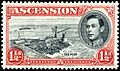
View of "The Pier" (1938)
-
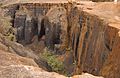
Devil's Ashpit
-
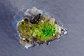
Satellite picture of Ascension Island in 2010


See also
 In Spanish: Isla Ascensión para niños
