
Diego Garcia facts for kids

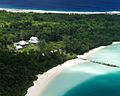
Aerial photograph of Diego Garcia
|
|

Diego Garcia
Location in Indian Ocean
Location of Diego Garcia
|
|
| Geography | |
|---|---|
| Coordinates | 7°18′48″S 72°24′40″E / 7.31333°S 72.41111°E |
| Archipelago | Chagos Archipelago |
| Adjacent bodies of water | Indian Ocean |
| Area | 30 km2 (12 sq mi) |
| Administration | |
| Territory | |
| Chagos Archipelago | |
| Demographics | |
| Population | 4,239 |
| Additional information | |
| Time zone | |
| Designated: | 4 July 2001 |
| Reference #: | 1077 |
Diego Garcia is the largest island in the Chagos Archipelago. It is part of the British Indian Ocean Territory (BIOT). Since the 1970s, the island has been a joint military base for the UK and the U.S. This happened after the UK government made its original inhabitants leave. In October 2024, the UK agreed to give the islands to Mauritius. However, the military base will stay under a 99-year lease.
This island is just south of the equator in the central Indian Ocean. It is about 3,535 km (2,197 mi) east of Tanzania. It is also 1,796 km (1,116 mi) southwest of India and 4,723 km (2,935 mi) northwest of Australia. Diego Garcia is part of an underwater mountain range called the Chagos–Laccadive Ridge. This ridge includes the Lakshadweep and Maldives islands. The island uses UTC+6 time all year.
Portuguese sailors found Diego Garcia in 1512. It was empty until the French started using it in the late 1700s. They used it as a place for people with leprosy and for coconut plantations. After the Napoleonic Wars, the British took control. The island was part of Mauritius until 1965. Then, it became part of the new BIOT.
In 1966, Diego Garcia had 924 people. Most were workers on coconut farms. But between 1968 and 1973, the local people, called Chagossians, were forced to leave. This was to make space for the military base. In 2019, the International Court of Justice said the UK's control of the Chagos Archipelago was against the law. The United Nations agreed. The UK said the ruling was not binding.
Diego Garcia is still the only island in the BIOT with people. Its population is made up of military staff and contractors. It is one of two important U.S. bomber bases in the Indo-Pacific area. The other is Andersen Air Force Base in Guam.
Contents
Island History: A Timeline
Early Days: Before Europeans Arrived
We don't have clear proof that people lived on Diego Garcia before Europeans came. Some think people from Austronesia visited around 700 AD. This is because an old Maldivian name for the islands might come from the Malagasy language. Arabs who reached Lakshadweep and Maldives around 900 AD might also have visited the Chagos. Old stories from the southern Maldives talk about traders and fishermen. They sometimes got stuck on unnamed Chagos islands and were later rescued.
European Discovery and Naming
The Portuguese explorer Pedro Mascarenhas found these empty islands in 1512. He first named it Dom Garcia. Another Portuguese trip with a Spanish explorer, Diego García de Moguer, found the island again in 1544. He named it after himself. Maps from the early 1500s showed the Maldives. But they did not clearly show the Chagos islands to the south.

The first map to show and name "Los Chagos" was by Pierre Desceliers in 1550. An island called "Don Garcia" appeared on a map by Abraham Ortelius in 1570. It was near "Dos Compagnos." Later, on a map by Jodocus Hondius in 1589, "Don Garcia" changed to "I. de Dio Gratia." The first map to use the name "Diego Garcia" was by Edward Wright in 1599. This name then spread to other maps.
First Settlements on the Island
Diego Garcia and the other Chagos islands were empty until the late 1700s. In 1778, the French Governor of Mauritius gave Diego Garcia to Monsieur Dupuit de la Faye. There is proof that French people visited to gather coconuts and fish. In 1786, some French people living in huts left Diego Garcia. This happened when the British East India Company tried to start a settlement.
The British settlement failed in October 1786. After the British left, the French colony of Mauritius started sending people with leprosy to the island. In 1793, the French set up a coconut plantation. They used slave labor to produce coconut fiber ropes and sea cucumbers.
Diego Garcia became a UK colony after the Napoleonic Wars. This was part of the Treaty of Paris (1814). From 1814 to 1965, Mauritius managed the island. The main plantations were at East Point, Minni Minni, and Pointe Marianne. Workers lived in these areas and in villages around the island. From 1881 to 1888, the island had two places for coaling stations. These helped steamships crossing the Indian Ocean.
Diego Garcia in the 20th Century


In 1914, a German warship, SMS Emden, visited the island during World War I. In 1942, the British opened RAF Station Diego Garcia. They set up a flying boat unit there. Catalina and Sunderland planes flew missions during World War II. They searched for Japanese and German submarines. Two large naval guns were also put in place to protect the base. The station closed in 1946 after the war.
In the early 1960s, the UK was reducing its military presence in the Indian Ocean. They agreed to let the United States build a naval communication station on one of their islands. The U.S. wanted an island with no people to avoid political problems. Both countries agreed that Diego Garcia was a good spot.
The UK Buys the Island

In November 1965, the UK bought the Chagos Archipelago, including Diego Garcia. They paid £3 million to Mauritius. The goal was to create the British Indian Ocean Territory (BIOT). This would be an empty British territory for U.S. military activities. In April 1966, the British government bought all the coconut plantation businesses in the BIOT. They leased them back for a short time. But the plantations were not making money.
On December 30, 1966, the U.S. and UK made a deal. The U.S. could use the BIOT for defense for 50 years. This agreement could be extended. The U.S. did not pay money directly. Instead, the UK got a $14 million discount on buying Polaris missiles from the U.S.
The U.S. saw Diego Garcia as a great place for a military base. It was far from threats and had few people. This made it ideal for security. Diego Garcia is sometimes called "Fantasy Island" because it is so isolated.

The main reason for choosing Diego Garcia was the idea that it had no native people. It was empty until the late 1700s. Its only residents were European managers and contract workers. These workers, called Chagossians, had African, Indian, and Malay roots. They had lived and worked on the plantations for generations. Before building the base, the British government told the U.S. that hundreds of people lived there. The actual number of Chagossians was around 1,000.
The Chagossians had to leave the island for the base to be built. In 1968, the first steps were taken to reduce the population. People who left the island for holidays or medical care were not allowed to return. Those who stayed had limited food and medical supplies. The hope was they would leave "willingly."
In March 1971, U.S. Navy construction teams arrived to build the communication station and airfield. To meet the agreement for an empty island, the plantation on Diego Garcia closed in October 1971. The workers and their families were moved to other islands. The Mauritian government did not want to take the islanders without payment. In 1974, the UK gave Mauritius £650,000 to help resettle them. Those who remained on Diego Garcia between 1971 and 1973 were forced onto cargo ships to Mauritius and the Seychelles.
By 1973, the Naval Communications Station was finished. The U.S. then asked to build a larger airfield and a place for ships. This was approved, and more workers came. After the Iran hostage crisis in 1979–1980, the U.S. got permission for a $400 million expansion. This included long runways, parking for bombers, new ship anchorages, and fuel storage. When U.S. bases in the Philippines closed in the 1990s, many workers moved to Diego Garcia.

Diego Garcia in the 21st Century
On June 23, 2017, the United Nations General Assembly (UNGA) voted to ask the International Court of Justice (ICJ) to look into the dispute over the Chagos Islands. In February 2019, the ICJ ruled that the UK should give the islands to Mauritius. The UK said this ruling was not legally binding. In May 2019, the UN General Assembly supported the ICJ's decision. It asked the UK to leave the islands and help Mauritian people return. The U.S. government said neither they nor the British planned to stop using the military base.
In June 2020, a Mauritian official said the U.S. could keep its base if Mauritius got control of the Chagos archipelago. On October 3, 2024, the UK Prime Minister Keir Starmer announced that the UK would hand over the Chagos islands to Mauritius. The joint base will remain, with the UK leasing it for 99 years. Mauritius can resettle people on other Chagos islands, but not on Diego Garcia because of the base. U.S. President Joe Biden welcomed this agreement.
Chagos Marine Protected Area
On April 1, 2010, the Chagos Marine Protected Area (MPA) was created. This protected the waters around the Chagos Archipelago. Mauritius disagreed, saying it went against their rights. In 2015, a court ruled that the MPA was illegal. This was because Mauritius had rights to fish and to any minerals or oil in the waters.
People of Diego Garcia
Diego Garcia had no permanent residents when it was found in the 1500s. This stayed true until the French settled it in 1793.
French Settlement and the Chagossians
Most people on Diego Garcia from 1793 to 1971 were plantation workers. There were also French-Mauritian managers, Indian-Mauritian administrators, and contract workers from Mauritius and Seychelles. Later, Chinese and Somali workers also came.
A unique culture called the Îlois developed from these workers. "Îlois" means "islanders" in French Creole. Now, they are called Chagos Islanders or Chagossians. They are mostly descendants of slaves brought from Madagascar by the French. Malay slaves from Pulo Nyas also came. The slave trade ended in 1833. The Îlois also developed their own French-based Creole dialect.
The Chagos Archipelago plantations usually had about 1,000 people. About two-thirds lived on Diego Garcia. The most people recorded was 1,142 in 1953. The main work was growing coconuts for copra or coconut oil. This continued until the plantations closed in 1971.
The Expulsion of 1971
All the people on Diego Garcia were forced to move by 1971. They went to other Chagos islands, Mauritius, or Seychelles. This was to meet the agreement between the UK and the U.S. to empty the island for the base. The UK and Mauritian governments agreed in 1972 that 426 families, totaling 1,151 people, should get money as exiled Îlois. By 1982, 1,579 people were officially recognized as Îlois.
Fifteen years after the last people were forced to leave, the Chagossians received some money from the British. Some got nothing. The British actions are still being discussed in courts. Today, many Chagossians are still poor. They live as "outsiders" in Mauritius and the Seychelles.
Life on the Island After 1971
From 1971 to 2001, only UK and U.S. military staff and civilian workers lived on Diego Garcia. This included contract workers from the Philippines and Mauritius. Some of these were even Îlois. During wars in Afghanistan and Iraq, soldiers from Australia, Japan, and South Korea were also based there.
Today, between 3,000 and 5,000 U.S. troops and support staff live on the island. The people living there now do not rely on the island for food. All food is brought in by ship or plane. Some fishing for fun is allowed. In 2004, U.S. Navy recruitment ads called Diego Garcia "one of the world's best-kept secrets." They praised its fun facilities and beautiful nature. Since October 2021, there have been asylum seekers on Diego Garcia.
Island Governance and Politics

Diego Garcia is the only inhabited island in the British Indian Ocean Territory (BIOT). The BIOT is an overseas territory of the United Kingdom. The BIOT government has a commissioner chosen by King Charles III. The commissioner works in London and is helped by an administrator.
The French first colonized Diego Garcia. It was given to the UK in 1814 after the Napoleonic Wars. Mauritius managed Diego Garcia and the Chagos Archipelago until 1965. Then, the UK bought them from Mauritius for £3 million. They became a separate British Overseas Territory.
Military Management of the Island
The UK handles the territory's international matters. There isn't a local government like you might expect. Instead, the British Forces commander on Diego Garcia, called the "Brit rep," represents the government. The commissioner makes laws, and the Brit rep enforces them.
A big concern for the BIOT government is its relationship with the U.S. military. They have an annual meeting in London called "The Pol-Mil Talks" to discuss issues. Neither the U.S. nor the UK agrees that Diego Garcia is part of the African Nuclear Weapons Free Zone Treaty. It is not publicly known if nuclear weapons have ever been stored on the island.
International Issues Affecting Diego Garcia
Two main international issues affect Diego Garcia:
- The island nation of Mauritius claims the Chagos Archipelago, including Diego Garcia. Mauritius also disagrees with the UK's decision in 2010 to make the BIOT a marine protected area. This area bans fishing and mining.
- The issue of paying and returning the former inhabitants, who were forced to leave in 1973, is still ongoing. Some groups say that Diego Garcia and its waters have been closed to the public since 1971.
On November 3, 2022, the British Foreign Secretary James Cleverly announced that the UK and Mauritius would start talks about who owns the British Indian Ocean Territory. Both countries agreed to keep the joint UK/U.S. military base on Diego Garcia running.
Nature and Environment
No plants, birds, amphibians, reptiles, molluscs, crustaceans, or mammals are found only on Diego Garcia. However, some fish and water creatures are unique to the area. All plants and wildlife are protected. Also, much of the lagoon is a protected wetland, called a Ramsar site. Large parts of the island are nature preserves. In 2004, the UK got Ramsar site status for the lagoon and waters of Diego Garcia.
Island Geography

Diego Garcia is the largest land area in the Chagos Archipelago. It covers about 174 square kilometers (67 sq mi). About 27.19 square kilometers (10.50 sq mi) is dry land. The island forms a ring that is about 64 km (40 mi) long. It surrounds a lagoon that is 21 km (13 mi) long and up to 11 km (6.8 mi) wide. There is a 6 km (3.7 mi) wide opening in the north. Three small islands are in this opening.
The island has the longest continuous dry land rim of any atoll in the world. This rim is from a few hundred meters to 2.4 km (1.5 mi) wide. Like other coral atolls, its highest point is about 9 meters (30 ft) above sea level on some sand dunes. The lagoon is about 19 km (12 mi) long and up to 8 km (5.0 mi) wide. The main island is the biggest of about 60 islands in the Chagos Archipelago. Besides the main island, there are three small islets at the lagoon's mouth: West Island, Middle Island, and East Island.
The total area of the atoll is about 170 square kilometers (66 sq mi). The lagoon is about 120 square kilometers (46 sq mi) and up to 25 meters (82 ft) deep. The total land area is about 30 square kilometers (12 sq mi). A coral reef surrounds the island on the ocean side. It is usually flat and shallow, about 1 meter (3.3 ft) deep. This reef is about 100 to 200 meters (330 to 660 ft) wide. Beyond the reef, the ocean floor drops very steeply.
Inside the lagoon, many coral heads make sailing tricky. The shallow reef on the ocean side does not allow ships to anchor. The channel and anchorage areas in the northern lagoon are deepened. There are also saltwater wetlands called barachois in the southern lagoon. These small lagoons fill with seawater at high tide and dry out at low tide. Scientists in 1996 and 2006 said the waters around Diego Garcia were "exceptionally unpolluted" and "pristine."
Diego Garcia often has earthquakes. These are caused by tectonic plate movement along the Carlsberg Ridge to the west. A strong earthquake in 1983 caused minor damage. In December 2004, a tsunami from Indonesia caused small changes to the shoreline.
Ocean and Climate
Diego Garcia is always affected by the South Equatorial Current. Ocean surface temperatures are warm, between 80–84°F (27–29°C) all year.

Diego Garcia has a tropical rainforest climate (Köppen Af). Temperatures are usually the same all year. The average high is 30°C (86°F) in March and April. From July to September, it's about 29°C (84°F). Night temperatures drop to around 27°C (81°F). Humidity is high, but a constant breeze makes it comfortable.
From December to March, winds are usually from the west. From June to September, strong winds from the southeast blow. All rain falls as showers. The island gets about 2,603.5 mm (102.50 in) of rain each year. January is the wettest month, and August is the driest. Thunderstorms often happen in the afternoon and evening during the summer (December to March).
Diego Garcia is at low risk from tropical cyclones. This is because it is close to the equator. Some weaker storms have hit the island. One in 1901 knocked down many coconut trees. Another in 1944 caused a plane wreck. A storm in 1990 destroyed a tent city for U.S. Air Force crews.

The island was somewhat affected by the tsunami in 2004. People on the western side saw only a small increase in waves. The island was mostly protected by its deep ocean features. A very deep underwater canyon, the Chagos Trench, is about 80 km (50 mi) east of the island. This trench makes it harder for big tsunami waves to form. Also, nearby coral reefs may have weakened the waves. A survey in 2005 showed some erosion from the tsunami. About 10% of the eastern shoreline was affected.
Fresh Water Supply
Diego Garcia is a coral atoll. Rainwater forms freshwater "lenses" that float on top of the saltwater underground. The island gets a lot of rain, about 260 cm (102.5 in) per year. This helps keep the freshwater supply full.
In the past, people used shallow wells and collected rainwater. Today, the military base uses over 100 shallow wells. They produce more than 560,000 liters (150,000 US gal) of water per day. This is enough for 3,500 people. This freshwater area holds about 19 million cubic meters (670 million cu ft) of water.
Taking too much fresh water can cause saltwater to mix in. Tsunamis and tropical storms can also spoil the water. Pollution from waste or spills can also harm the water. It can take years for the water to become clean again.
Some natural low areas on the island collect rainwater. These form freshwater wetlands. They are important for wildlife and help refill the freshwater lenses. There are also man-made ponds from digging during construction.
Island Plants and Trees

The first studies of the island's plants were in 1883. At that time, coconut plantations had been running for 100 years. So, we don't know much about the plants before humans arrived. Newer studies show that new plant species arrive quickly. On average, three new plant species arrived each year between 1993 and 2003.
In 1967, a study described the island's plants. It said the coast had a hedge of Scaevola taccada. Inland, Cocos nucifera (coconut) was the most common tree. It covered most of the island. Some areas were like parks, with short plants. Other areas were thick with young coconut trees and seedlings.

There are also areas of old tropical hardwood forests. These are found where old plantation villages were. There are also forests of Casuarina equisetifolia (iron wood pines). In 1997, a survey found about 280 types of land plants on Diego Garcia. None of these were found only on the island. Another survey in 2005 found only 36 species that were "native." This means they arrived without human help and are found elsewhere. No land plants are currently at risk of disappearing.
The 36 native plants include 12 trees, five shrubs, seven herbs, three grasses, four vines, and five ferns. Many other plant species are "weedy" or "naturalized alien species." These were brought by humans, either by accident or on purpose as garden plants or crops. They have now spread naturally.

In 2004, scientists recognized 10 main types of plant groups on the island:
- Calophyllum forest: Dominated by large Calophyllum inophyllum trees.
- Cocos forest: Mostly coconut trees.
- Cocos-Hernandia forest: A mix of coconut and Hernandia sonora trees.
- Cocos-Guettarda forest: A mix of coconut and Guettarda speciosa trees.
- Hernandia forest: Dominated by Hernandia sonora trees.
- Premna shrubland: Mostly Premna obtusifolia shrubs.
- Littoral scrub: Lines the seashore and lagoon. Dominated by Scaevola taccada.
- Maintained areas: Grasslands and park-like areas kept mowed by the military.
- Mixed native forest: No single dominant tree species.
- Marshes: Divided into cattail, wetland, and mixed species types.


Island Wildlife

All land and water animals on Diego Garcia are protected. The only exceptions are certain game fish, rats, and cats. There are big fines for harming protected animals.
Crabs and Other Crustaceans
The island is home to many types of crustaceans. "Warrior crabs" (Cardisoma carnifex) are everywhere in the jungle at night. The very large coconut crab (Birgus latro) is also found here in big numbers. Because they are protected, there are more coconut crabs here than almost anywhere else.
Mammals on the Island
No mammal species are native to Diego Garcia. There are no records of bats. All "wild" mammals are actually wild descendants of pets. In the past, Diego Garcia had many donkeys, horses, dogs, and cats. In 1971, the BIOT Commissioner ordered that all wild dogs be killed. Donkeys, which numbered over 400 in 1972, were down to only 20 in 2005. The last horse was seen in 1995. By 2005, only two cats were thought to have survived a program to remove them.
Native Birds of Diego Garcia

The Chagos Archipelago, including Diego Garcia, has 91 bird species. Sixteen species have large breeding groups. No birds are found only here. But there are important seabird colonies. Diego Garcia has many seabirds that are decreasing in other parts of the Indian Ocean. Large groups of brown noddies, bridled terns, lesser noddies, red-footed boobies, and lesser frigatebirds nest on Diego Garcia.
Other native birds that nest here include red-tailed tropicbirds, wedge-tailed shearwaters, Audubon's shearwater, black-naped terns, white terns, striated herons, and white-breasted waterhens. The 680-hectare Barton Point Nature Reserve is an Important Bird Area because of its large colony of red-footed boobies.
Introduced Bird Species
The island also has bird species brought from other places. These include cattle egrets (Bubulcus ibis), Indian barred ground doves (Geopelia striata), turtle doves (Nesoenas picturata), Indian mynahs (Acridotheres tristis), Madagascar fodies (Foudia madagascariensis), and chickens (Gallus gallus).
Reptiles and Amphibians
Currently, three types of lizards and one toad live on Diego Garcia. One snake might also be present. All are thought to have been brought by humans. These include the house gecko (Hemidactylus frenatus), the mourning gecko (Lepidodactylus lugubris), the garden lizard (Calotes versicolor), and the cane toad (Bufo marinus). A type of blind snake, probably the brahminy blind snake (Ramphotyphlops braminus), might also live here. This snake eats ant and termite larvae.
Sea Turtles
Diego Garcia is a good place for hawksbill turtles (Eretmochelys imbricata) and green turtles (Chelonia mydas) to feed and nest. Young hawksbills are common in the lagoon. Adult hawksbills and greens are common in the surrounding seas. They nest regularly on the ocean-side beaches. Hawksbills nest in June and July, and from November to March. Green turtles nest every month. An estimated 300–700 hawksbills and 400–800 green turtles nest in the Chagos.
Endangered Species
Four reptiles and six types of whales are endangered. They may or may not be found on or around Diego Garcia. These include the hawksbill turtle, leatherback turtle, green turtle, olive ridley turtle, sperm whale, sei whale, finback whale, Bryde's whale, blue whale, humpback whale, and southern right whale.
UK Military Presence
British Forces British Indian Ocean Territories (BFBIOT) is the official name for the British Armed Forces on Diego Garcia. The naval and airbase facilities are leased to the United States. But it works as a joint UK-U.S. base. The UK has full access. Diego Garcia is in a key location. It offers access to East Africa, the Middle East, and Southeast Asia. The base helps prepare or resupply military forces before operations. About 40–50 British military personnel are stationed on Diego Garcia. Most are from Naval Party 1002 (NP1002). NP1002 manages the island's civil administration.
U.S. Military Presence

During the Cold War, the U.S. wanted a military base in the Indian Ocean. This was to counter Soviet influence and protect oil routes. The U.S. saw the atoll as an "unsinkable aircraft carrier." It was useful during the Iranian revolution, the Iraqi invasion of Kuwait, Operation Desert Fox, Operation Enduring Freedom, and Operation Iraqi Freedom. Today, the atoll is still a key military hub for the U.S. in the Indian Ocean.
The U.S. military facilities on Diego Garcia are sometimes called Camp Justice or Camp Thunder Cove. Officially, it is Naval Support Facility Diego Garcia (U.S. name) or Permanent Joint Operating Base (PJOB) Diego Garcia (UK name).
U.S. military activities on Diego Garcia have sometimes caused tension with India. The CPI(M) in India has asked for the base to be removed. They saw the U.S. presence as a threat to peace. But in recent years, relations between India and the U.S. have gotten much better. Diego Garcia was used for naval exercises between the U.S. and Indian navies from 2001 to 2004.
Recent construction at the base includes a new 34-meter antenna and two new 13-meter radomes. Old power and telephone lines are also being moved underground.


Naval Support Facility Diego Garcia provides support services to commands on the island. Its job is to give "logistic support to operational forces" in the Indian Ocean and Persian Gulf. KBR has managed the base operations support services.
U.S. Air Force Units on Diego Garcia
- 36 MSG, Pacific Air Force
- Det 1, 730th Air Mobility Squadron, Air Mobility Command
- Det 1, 21st Space Operations Squadron, a Satellite Control Network Remote Tracking Station, Space Operations Command
- Det 2, a GEODSS facility, Space Operations Command
U.S. Pre-positioned Vessels

The atoll protects ships of the United States Marine Pre-positioning Squadron Two. These ships carry equipment and supplies for a large armed force. This includes tanks, armored vehicles, weapons, fuel, and even a mobile hospital. This equipment was used during the Persian Gulf War.
The ships in this squadron change. In August 2010, it had ships like the MV Capt. Steven L. Bennett and USNS SGT William R. Button. Five of these ships carry supplies for the U.S. Marine Corps. These supplies can support a Marine Air-Ground Task Force for 30 days.
Before 2001, the squadron had up to 20 ships. These included ships that carried barges with Army ammunition. There were also logistics vessels for the United States Air Force, United States Navy, and Defense Logistics Agency. These included container ships for Air Force weapons, a 500-bed hospital ship, and fuel tankers.
High Frequency Global Communications System
The U.S. Air Force runs a High Frequency Global Communications System site here. It is on the south end of the atoll. This site is controlled from Andrews Air Force Base and Grand Forks Air Force Base. Local staff maintain it.
Naval Computer and Telecommunications Station Far East Detachment Diego Garcia operates a unit on the island. This unit provides base phone services, network services, and satellite communication. It also maintains the Air Force's remote communication terminal. In July 2023, a new underwater fiber-optic cable was connected to Diego Garcia.
The Naval Security Group detachment Diego Garcia closed on September 30, 2005. Its remaining tasks were given to a contractor. A large antenna array has been taken down. But four satellite antenna radomes are still there.
Space Shuttle Landing Site
The island was chosen as one of the emergency landing sites worldwide for the NASA Space Shuttle. However, these facilities were never used during the shuttle program.
Cargo Services

All food and equipment are brought to Diego Garcia by sea or air. All waste that cannot break down is also shipped off the island. From 1971 to 1973, U.S. Navy ships provided this service. After 1973, civilian ships were hired. From 2004 to 2009, the U.S.-flagged container ship MV Baffin Strait delivered 250 containers every month from Singapore. It carried over 200,000 tons of cargo each year. On its way back to Singapore, it carried recyclable metals.
In 2004, TransAtlantic Lines won the transport contract. Their ship, the Baffin Straits, operated from January 2005 to September 2008.
Images for kids
-
Coconut plantation, East Point (former main settlement)

See also
 In Spanish: Diego García para niños
- James Horsburgh
- List of British Army installations
- List of United States military bases
- Robert Moresby
- Stealing a Nation
