
Edward Wright (mathematician) facts for kids
Quick facts for kids
Edward Wright
|
|
|---|---|

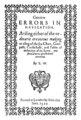
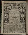
Title page of the first edition of Wright's Certaine Errors in Navigation (1599)
|
|
| Born |
Garveston, Norfolk, East Anglia, England
|
| Died | November 1615 (aged at least 54) London, England
|
| Nationality | English |
| Alma mater | Gonville and Caius College, Cambridge |
| Known for | Writing Certaine Errors in Navigation (1599) which first explained the mathematical basis for the Mercator projection, producing the Wright–Molyneux map (c. 1599), and translating John Napier's work on logarithms which was published as A Description of the Admirable Table of Logarithmes (1616) |
| Scientific career | |
| Fields | Mathematics; navigation; cartography |
| Influenced | Adriaan Metius, Richard Norwood, Willebrord Snellius |
Edward Wright (born 8 October 1561; died November 1615) was an English mathematician and mapmaker. He is famous for his book Certaine Errors in Navigation (1599). This book was the first to explain the math behind the Mercator projection. This special map type is super useful for sailors.
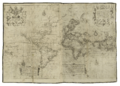
Wright was born in Garvestone in Norfolk, England. He studied at Gonville and Caius College, Cambridge. He was a fellow there from 1587 to 1596. In 1589, Queen Elizabeth I asked him to join a sea trip. This trip was led by the Earl of Cumberland to the Azores. Their goal was to capture Spanish ships. The map of this trip was the first to use Wright's new way of drawing maps. It was published in his book in 1599. That same year, Wright also made the first world map produced in England. It was also the first to use the Mercator projection since Gerardus Mercator's original map in 1569.
After 1600, Wright became a surveyor for the New River project. This project built a new channel to bring clean water to London. Around this time, Wright also taught math to sailors. From 1608, he tutored Prince Henry, the son of King James I. Wright was also great at designing math tools. He made models of an astrolabe and a pantograph. He also made a special armillary sphere for Prince Henry. In the 1610 edition of his book, he described cool inventions. These included the "sea-ring" for finding the compass variation. He also made a tool to find latitude using the North Star.
Wright also translated John Napier's important 1614 book. This book introduced the idea of logarithms. Wright translated it from Latin into English. It was published after Wright's death in 1616. Wright's work helped many other smart people. These included the Dutch astronomer Willebrord Snellius and the English mathematician Richard Norwood.
Contents
Early Life and Education
Edward Wright was the younger son of Henry and Margaret Wright. He was born in Garvestone, Norfolk. He was baptized on 8 October 1561. He went to Gonville and Caius College, Cambridge in 1576. He was a "sizar," meaning he paid lower fees. He often worked for the college to help pay for his studies.
Wright earned his first degree in 1580–1581. He stayed at Caius College and got his Master of Arts degree in 1584. He was a fellow there from 1587 to 1596. At Cambridge, he became good friends with Robert Devereux. He also met the mathematician Henry Briggs. Another friend was the soldier and astrologer Christopher Heydon. Heydon later used instruments Wright made for him to study the stars.
Adventures at Sea

In 1589, Queen Elizabeth I asked Wright to join a sea trip. This trip was organized by the Earl of Cumberland. They sailed to the Azores to capture Spanish ships. The college gave Wright special permission to go. He sailed with Cumberland from Plymouth on 8 June 1589. They returned on 27 December of the same year. Wright wrote about this trip in his book Certaine Errors of Navigation.
Some people thought Wright had been on an earlier trip with Sir Francis Drake. But there is no clear proof of this. Wright himself only talked about his trip with the Earl of Cumberland. He never mentioned any other sea voyages. After this trip, Wright went back to Cambridge. But he soon moved to London. In 1595, he married Ursula Warren. They had a son named Samuel and other children who sadly died young. Wright left his fellowship in 1596.
Mapping the World
Explaining the Mercator Map

Edward Wright helped a mapmaker named Emery Molyneux. He helped him draw coastlines on his globe. Wright also translated some of the globe's labels into Latin. Molyneux's globes were the first made in England. Wright explained how to use them in his 1599 book, Certaine Errors in Navigation. He gave the book to the Earl of Cumberland. He said the Earl encouraged him to use his math skills for navigation.
In his book, Wright fixed common errors in sea charts. He built on the ideas of Pedro Nunes. Nunes was a Portuguese mathematician. He had discussed how to follow a straight path on a curved globe. Gerardus Mercator created the Mercator projection in 1569. But he never explained how he made it. Wright's book finally explained the math behind it.
Wright showed how to divide the map's meridians (lines from pole to pole). He created a table to help mapmakers. On a globe, lines of latitude get shorter as they go towards the poles. On a Mercator map, these lines are stretched to be the same length as the Equator. This makes them farther apart as they get closer to the poles. Wright's table showed how far apart these lines should be. This made it easy for anyone to draw an accurate Mercator map.

The first edition of Wright's book had a short table. The second edition in 1610 had a much longer, more detailed table. This table was incredibly accurate. Wright also added other improvements to the second edition. He included ways to measure the Earth's size. He also corrected errors when using tools like the Jacob's staff. He added tables of sun and star positions. He also included a big table of compass variations around the world.
Wright decided to publish his book because others used his work without giving him credit. A Dutch mapmaker named Jodocus Hondius borrowed Wright's notes. Hondius promised not to publish them. But he used Wright's math for his own maps, including a world map in 1597. Wright was very upset by this. He wrote in his book's preface: "I wish I had been as wise as he [Mercator] in keeping it more charily to myself."
New Maps and Discoveries


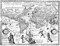
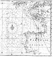
The first map made with Wright's method was in his book. It showed the route of Cumberland's trip to the Azores. Wright then created a new world map. This was the first world map made in England. It was also the first to use the Mercator projection since Mercator's original map. This map, often called the Wright–Molyneux Map, appeared in Richard Hakluyt's book in 1599. Unlike other maps of the time, Wright's map left blank areas where information was missing. This showed he was very honest about what was known. This map was also one of the first to use the name "Virginia".
Wright also translated a book by the Flemish mathematician Simon Stevin. It was called The Haven-Finding Art (1599). He also wrote the introduction to William Gilbert's famous book De Magnete (1600). This book explained that the Earth acts like a giant magnet. Wright also helped write a pamphlet about a tool called a "dip-compass." This tool could help sailors find their latitude. In 1602, he wrote The Description and Use of the Sphære, which was published later.
Bringing Water to London

Wright also became known as a land surveyor. He worked on a plan to bring a new river from Uxbridge to London. But this plan did not happen. However, in the early 1600s, he was hired by Sir Hugh Myddelton. Wright became the surveyor for the New River project. This project built a new channel to bring clean water from Ware to Islington, London.
The distance from Ware to London is about 20 miles in a straight line. But Wright had to plan a route over 40 miles long. This was because the river had to follow a specific height line. Water had to flow by gravity, with only a small drop in height per mile. This needed great surveying skill.
Work on the New River started in 1608. It stopped for a while due to money problems and landowners' objections. But it started again in 1611. The New River officially opened on 29 September 1613. It still supplies London with water today!
Cool Inventions and Logarithms
Wright often suggested that a special teaching position be created for sailors. This would help them learn navigation. He convinced Admiral Sir William Monson to support this idea. Wright became a math teacher for merchant sailors. Later, the English East India Company sponsored these lessons.
Wright also taught math to Prince Henry, King James I's son. This was from 1608 until the Prince's death in 1612. Wright dedicated the second edition of his book Certaine Errors to Prince Henry. He also drew many maps for the Prince. These included a map of the Northwest Passage.
Wright was a very talented designer of math tools. He made models of an astrolabe and a pantograph. He also made a special wooden armillary sphere for Prince Henry. This sphere showed how the sun, moon, and stars move. It could even show eclipses! Wright published a book about this sphere in 1613.
The 1610 edition of Certaine Errors also described other inventions. These included the "sea-ring." This tool helped sailors find the compass's magnetic variation. It could also tell them the sun's height and the time of day. He also invented a "sea-quadrant" for measuring heights. And a tool to find latitude using the North Star.

In 1614, Wright published a small book about making sundials. But his main focus was on John Napier's book about logarithms. Logarithms are a way to simplify complex calculations. Wright quickly saw how useful logarithms would be for navigation. He translated Napier's book from Latin into English. Napier himself approved Wright's translation.
Wright died in November 1615. He was buried on 2 December 1615 in London. His translation of Napier's book was finished by his son Samuel and Henry Briggs. It was published after Wright's death in 1616. It was called A Description of the Admirable Table of Logarithmes. In this book, Wright was praised as "England's great Pilot, Mariners Director."
Many later mathematicians used Wright's work. This shows how important his contributions were. He was praised by other writers for his work on navigation. One writer even said that Mercator's map should "more properly be called Wright's chart." Wright truly studied to help others more than himself.
Works
Authored

- Certaine Errors in Navigation. London: Printed ... [by Valentine Simmes and W. White] for Ed. Agas, 1599.
- Chapter 12 of book 4 of De Magnete, Magneticisque Corporibus, et de Magno Magnete Tellure (Latin). London: Petrus Short, 1600.
- The Making, Description and Use of the Two Instruments for Seamen to find out the Latitude ... First Invented by Dr. Gilbert, published in Thomas Blundeville's The Theoriques of the Seuen Planets. London: Printed by Adam Islip, 1602.
- The Description and Use of the Sphære. London: Printed by J. Beale for William Welby, 1613.
- A Short Treatise of Dialling: Shewing, the Making of All Sorts of Sun-dials. London: Printed by Humfrey Lownes, for George Busby, 1614.
Edited and translated

- Stevin, Simon. The Haven-Finding Art, or the Way to Find any Haven or Place at Sea, by the Latitude and Variation. London: Imprinted by G.B. R.N. and R.B. for Simon Waterson, 1599.
- Zamorano, Rodrigo. Compendio de la Arte de Navegar (Compendium of the Art of Navigation). Seville, 1581. Translated by Edward Wright.
- Napier, John. A Description of the Admirable Table of Logarithmes. London: Printed by Nicholas Okes, 1616.
Images for kids
-
Title page of the first edition of Wright's Certaine Errors in Navigation (1599)
-
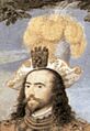
Hilliard's portrait of George, Earl of Cumberland (c. 1590). Wright dedicated his book Certaine Errors in Navigation to him.
-
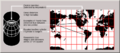
Wright explained the Mercator projection by imagining a globe inflating inside a cylinder. This makes the map flat and useful for sailors.
-
Hondius used Wright's math without saying so in his 1597 map. This made Wright publish his book.
-
Edward Wright's map for sailing to the Azores (c. 1595). This was the first map made using his new projection method.
-
Wright's "Chart of the World on Mercator's Projection" (c. 1599), also known as the Wright–Molyneux map.
-

The New River at Enfield Town Park in London.
-
The Scotsman John Napier (1550–1617), who invented logarithms.
-
Title page of Wright's Certaine Errors in Navigation (Second edition, 1610)
-
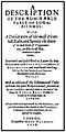
Title page of Admirable Table of Logarithmes (2nd ed., 1618)
