
Lakshadweep facts for kids
Quick facts for kids
Lakshadweep
|
|||||||||||||||||||
|---|---|---|---|---|---|---|---|---|---|---|---|---|---|---|---|---|---|---|---|
     Clockwise from top: Kadmat Island; Minicoy Island; Agatti Island with airport; Reefs in Laccadive Sea;and Kalpeni Island
|
|||||||||||||||||||
|
|||||||||||||||||||

Location of Lakshadweep in India
|
|||||||||||||||||||
| Country | |||||||||||||||||||
| Region | South India | ||||||||||||||||||
| Formation | 1 November 1956 | ||||||||||||||||||
| Capital | Kavaratti | ||||||||||||||||||
| Largest city | Andrott | ||||||||||||||||||
| Government | |||||||||||||||||||
| • Body | Government of Lakshadweep | ||||||||||||||||||
| National Parliament | Parliament of India | ||||||||||||||||||
| • Lok Sabha | 1 seat | ||||||||||||||||||
| High Court | Kerala High Court | ||||||||||||||||||
| Area | |||||||||||||||||||
| • Total | 32.62 km2 (12.59 sq mi) | ||||||||||||||||||
| Area rank | 36th | ||||||||||||||||||
| Population
(2011)
|
|||||||||||||||||||
| • Total | 64,473 | ||||||||||||||||||
| • Density | 1,976/km2 (5,120/sq mi) | ||||||||||||||||||
| Language | |||||||||||||||||||
| • Official | English | ||||||||||||||||||
| • Additional official | Malayalam | ||||||||||||||||||
| Time zone | UTC+05:30 (IST) | ||||||||||||||||||
| ISO 3166 code | IN-LD | ||||||||||||||||||
| Vehicle registration | LD | ||||||||||||||||||
| HDI (2019) | 0.751 (4th) | ||||||||||||||||||
| Literacy (2011) | 91.85% | ||||||||||||||||||
| Sex ratio (2011) | 947♀/1000 ♂ (1st) | ||||||||||||||||||
|
|||||||||||||||||||

Lakshadweep (Malayalam: [lɐkʂɐd̪βʷiːbɨ̆]) is a special group of islands in India. It is a union territory, which means it is directly governed by the central Indian government. This beautiful place is made up of 36 islands, though one island, Parali 1, has been covered by the sea. These islands are split into three main groups: the Amindivi Islands in the north, the Laccadive Islands, and Minicoy Island in the south.
The islands are located in the Arabian Sea and the Laccadive Sea. They are about 220 to 440 kilometers away from the mainland of India. Lakshadweep covers a small land area of about 32.62 square kilometers. In 2011, about 64,473 people lived on the ten islands that are inhabited. The islands have a long coastline of 132 kilometers and a huge lagoon area.
Lakshadweep is part of a long chain of islands. This chain includes the Maldives and Chagos islands. These islands are actually the tops of a massive underwater mountain range. The main city and capital of Lakshadweep is Kavaratti.
People have lived on these islands for a very long time. Evidence from Kalpeni shows settlements from at least 1500 BCE. Ancient stories and writings from India also mention the islands. Over centuries, different kingdoms ruled Lakshadweep, including the Cheras, Pallavas, and Cholas. Islam came to the islands in the 7th century CE. Later, the Portuguese and then the British controlled the islands. After India became independent in 1947, Lakshadweep became a union territory in 1956.
The name Lakshadweep means "one hundred thousand islands" in Malayalam and Sanskrit. Even though there are fewer islands, the name gives a sense of many. English is the official language. However, most people speak Jeseri, which is a type of Malayalam. On Minicoy Island, people mostly speak Dhivehi. The islands' legal matters are handled by the Kerala High Court. Fishing and farming are the main jobs for the people living here.
Contents
What's in a Name?
The name Lakshadweep comes from the words Lakṣadvīpa. This means "one hundred thousand islands" in Sanskrit or Malayalam. The name "Laccadive" was given by the British. It is an English version of the original name.
The Amindivi islands get their name from the Amindivi people. They were some of the first people to live on Amini Island. The local name for Minicoy Island is Maliku. The name "Minicoy" is an English version from a word used in the Andaman and Nicobar islands.
A Look at History
Early Times
Scientists once thought that early humans might have traveled through these islands. This was because of their location between Africa and India. But later studies showed that most people on the islands came from South Asia.
We know people lived here as early as 1500 BCE. This is based on things found on Kalpeni island. The islands are also mentioned in old Buddhist stories from the 3rd century CE. Some people believe that Sanghmitra, the daughter of Emperor Ashoka, visited the islands. Old Tamil writings also say that the Cheras, a powerful kingdom, ruled these islands.
Sailors knew about these islands since at least the 1st century CE. An old book called Periplus of the Erythraean Sea mentions them. It says the islands were a source of turtle shells. In the 2nd century CE, a Greek historian named Ptolemy wrote about 1378 islands. He even named some of them, like Kanathara (Kavaratti) and Ammine (Amini). The islands were part of trade routes with the Roman Empire. This is known from old items found on Kadamath and Androth islands. Other famous travelers also wrote about the islands.
Middle Ages
Local stories say that the first people settled here because of Cheraman Perumal. He was the last Chera king of Kerala. However, there is no strong historical proof for this. But old ways of organizing society, like the Hindu caste system, were present.
Local tradition says that Islam came to the islands in 661 CE. It was brought by a person named Ubaidullah. His grave is believed to be on Andrott island. In the late 7th century CE, the Pallavas from Kanchi took control of the islands. Later, in the 10th century CE, the Kadambas also ruled parts of the region.
In the 11th century CE, the islands became part of the Chola kingdom. Records show that Rajendra Chola I captured the region in 1018-19 CE. After that, it was part of a small Hindu kingdom. Then, in the early 12th century CE, it went to the Kingdom of Kannur. Famous travelers like Marco Polo and Ibn Battuta wrote about the islands in the 13th and 14th centuries.
European Control

In the late 15th century CE, the Portuguese took control. They used the islands to make coir, which is fiber from coconuts. But the local people fought back and forced the Portuguese out in 1545 CE.
In the mid-16th century CE, the islands were given to the ruling family of Kannur. This was done by the Chirakkal family to protect the islands from the Portuguese. Later, in 1787 CE, the Aminidivi islands came under the rule of Tipu Sultan of Mysore. The British then took these islands in 1799 CE after a war. The other islands stayed under the Arakkal family. They paid a yearly tribute to the British. In 1908 CE, the British took full control of these islands too. This was because the Arakkal family did not pay their taxes. The islands then became part of the Madras Presidency.
After Independence
After India became independent in 1947, the islands joined the new country. They first became part of the Madras State. In 1956, the islands were made a separate union territory. This meant they were governed directly by the Indian government.
The islands were first called Laccadive, Minicoy, and Amindivi Islands. On November 1, 1973, they were renamed Lakshadweep islands. The main office for the territory was in Kozhikode until 1964. Then, it moved to Kavaratti. Because of their location, the islands have become an important base for the Indian navy. They are near important shipping routes from India to the Middle East.
Island Geography


Lakshadweep is a group of 36 islands and smaller islets. It includes 12 atolls, which are ring-shaped coral reefs. There are also three reefs and five underwater banks. The total land area is about 32.62 square kilometers. Only ten of these islands have people living on them.
The islands are located in the Arabian Sea to the west and the Laccadive Sea to the east. They are about 220 to 440 kilometers off the coast of mainland India. The islands are divided into three main groups. The Amindivi islands are in the north. The Laccadive islands are in the middle. Minicoy island is in the south. The islands have a long coastline of 132 kilometers. They also have a large lagoon area of 4200 square kilometers.
These islands are the northernmost part of a huge underwater mountain range. This range is called the Chagos-Lakshadweep Ridge. Scientists are still studying how these atolls were formed. One idea, from Charles Darwin, is that they formed when a volcanic island slowly sank. The coral reef around it kept growing upwards.
The individual islands are quite small. None of them are more than 1.6 kilometers wide. Most of the islands where people live are on the eastern side. The soils are mostly sandy, made from coral. A report from 2017 showed that one island, Parali I, has completely disappeared under the sea. Other islands in the same atoll are also shrinking due to erosion.
Island Climate
The islands have a tropical monsoon climate. This means the weather is warm all year round. Temperatures usually range from 20 to 32 degrees Celsius. Tropical storms from the Arabian Sea rarely hit the islands directly. This is because the islands are small. However, the strong winds and waves from these storms can change the shape of the islands.
| Climate data for Lakshadweep 1981–2010, extremes 1996–2012 | |||||||||||||
|---|---|---|---|---|---|---|---|---|---|---|---|---|---|
| Month | Jan | Feb | Mar | Apr | May | Jun | Jul | Aug | Sep | Oct | Nov | Dec | Year |
| Record high °C (°F) | 35.3 (95.5) |
35.3 (95.5) |
38.0 (100.4) |
37.8 (100.0) |
37.0 (98.6) |
37.8 (100.0) |
32.7 (90.9) |
34.8 (94.6) |
33.3 (91.9) |
35.0 (95.0) |
35.0 (95.0) |
36.3 (97.3) |
38.0 (100.4) |
| Mean daily maximum °C (°F) | 31.2 (88.2) |
31.5 (88.7) |
32.4 (90.3) |
33.2 (91.8) |
32.8 (91.0) |
31.1 (88.0) |
30.4 (86.7) |
30.5 (86.9) |
30.5 (86.9) |
30.9 (87.6) |
31.4 (88.5) |
31.3 (88.3) |
31.4 (88.5) |
| Mean daily minimum °C (°F) | 25.8 (78.4) |
26.0 (78.8) |
27.0 (80.6) |
28.1 (82.6) |
27.6 (81.7) |
25.9 (78.6) |
25.7 (78.3) |
25.8 (78.4) |
25.8 (78.4) |
26.1 (79.0) |
26.1 (79.0) |
25.9 (78.6) |
26.3 (79.3) |
| Record low °C (°F) | 22.5 (72.5) |
23.5 (74.3) |
24.2 (75.6) |
23.2 (73.8) |
22.1 (71.8) |
22.3 (72.1) |
22.7 (72.9) |
22.5 (72.5) |
22.7 (72.9) |
22.2 (72.0) |
22.1 (71.8) |
22.8 (73.0) |
22.1 (71.8) |
| Average rainfall mm (inches) | 8.3 (0.33) |
2.0 (0.08) |
0.5 (0.02) |
5.6 (0.22) |
85.1 (3.35) |
260.5 (10.26) |
400.1 (15.75) |
395.5 (15.57) |
309.6 (12.19) |
99.1 (3.90) |
27.5 (1.08) |
9.1 (0.36) |
1,602.9 (63.11) |
| Average rainy days | 2.1 | 0.9 | 0.1 | 0.4 | 6.5 | 16.0 | 16.1 | 12.5 | 10.0 | 9.3 | 5.5 | 2.4 | 79.5 |
| Average relative humidity (%) (at 17:30 IST) | 69 | 68 | 67 | 67 | 72 | 79 | 80 | 78 | 78 | 77 | 75 | 70 | 73 |
| Source: India Meteorological Department | |||||||||||||
Plants and Animals


Lakshadweep is part of a special forest area. However, there are no large forests on the islands. Scientists have found almost 400 types of flowering plants here. These include sea grasses and other plants like coconut trees. You can also find fungi, algae, and lichens. Common plants on the coast include shrubs and seaweeds.
The waters around Lakshadweep are full of life. There are over 600 kinds of marine fish. You can also find 78 types of corals and 82 kinds of seaweed. Many crabs, lobsters, and other sea creatures live here. Lakshadweep is one of India's four main coral reef areas.
Many different whales and dolphins live near the Lakshadweep Islands. These include blue whales, sperm whales, and orcas. You can also see sharks, tuna, and manta rays. Octopuses, crabs, and turtles are common too. On land, you might see cattle and poultry, which were brought here by people.
There are 101 types of birds. Common birds include the brown noddy and sooty tern. Water birds like herons and gulls are also seen. Pitti island is a special bird sanctuary. It is an important place for sea turtles to lay eggs. Many sea birds also breed there.
| Animal | Butterfly fish (Chaetodon falcula) |  |
Bird | Sooty tern (Sterna fuscata) |  |
| Tree | Bread fruit (Artocarpus incisa) |  |
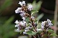
Flower | Neelakurinji (Strobilanthes kunthiana) |  |
People of Lakshadweep
In 2011, Lakshadweep had a population of 64,473 people. This included slightly more males than females. For every 1,000 males, there were 946 females. The islands also had the highest number of female births compared to male births in India in 2021. Most people, about 78%, live in towns. In 2017, the literacy rate was very high, at 92.28%. This means most people can read and write. The birth rate was also low, at 1.4 children per family.
Religions and Groups
| Religion in Lakshadweep (2011) | ||||
|---|---|---|---|---|
| Religion | Percent | |||
| Islam | 96.58% | |||
| Hinduism | 2.77% | |||
| Christianity | 0.49% | |||
| Others | 0.16% | |||
Most people on the islands follow Islam, about 96.6%. The main type of Islam is Sunni Islam. A smaller number of people are Hindu (2.8%) or Christian (0.5%). Most of the islanders are related to people who moved from the Malabar coast of Southwest India. They are similar to the Mappilas of Kerala.
Local stories say that Islam was brought to the islands by Ubaidullah in 661 CE. Even though Islam is the main religion now, the first people were probably Hindus. This is suggested by old social structures and family systems. On the southernmost island of Minicoy, people are called Mahls. This group also lives in the Maldives.
Languages Spoken
| Languages of Lakshadweep (2011) | ||||
|---|---|---|---|---|
| Language | Percent | |||
| Malayalam (Jeseri) | 84.17% | |||
| Dhivehi (Mahl) | 14.44% | |||
| Others | 1.39% | |||
English is the official language of Lakshadweep. Malayalam is also an official language. Most people in the Amindivi and Laccadive islands speak Jeseri. This is a type of Malayalam. On Minicoy, people speak Mahl, which is a type of Dhivehi. There are small differences in the language from island to island.
Malayalam, written in the Malayalam script, became the main language during British rule. Before that, people used an Arabic script to write Malayalam. Malayalam is still used as a common language across all the islands, including Minicoy.
How People Make a Living

The economy of Lakshadweep mostly depends on farming and fishing. Tourism is also growing. As of 2013, there were 72 small businesses. These businesses mainly made food products and furniture. The islands export coconut products, like coconut fiber (coir), and fish. Since there is little land for farming, coconuts are the main crop. The government runs factories that make coir fiber, yarn, and mats.


Fishing is a very important industry. The islands have a huge area of water where fishing is allowed. About 60% of the fish caught are tuna. Most of the fish caught are dried. The rest is eaten by local people. Fishing is done using modern boats and traditional boats. The government also has a factory that cans tuna.
Tourism in Lakshadweep started in 1974. That's when Bangaram atoll was opened for international visitors. In 2018, over 10,000 local tourists and over 1,300 foreign tourists visited. The government wants to use tourism to help local people earn more money. Bangaram and Kadmat islands are being promoted for tourism.
With beautiful marine life and coral reefs, many water sports are popular. These include scuba diving, windsurfing, and snorkeling. Kayaking, canoeing, and water skiing are also available. Tourists need special permission to visit the islands. Foreign visitors cannot go to some islands. The government is planning to improve tourism and facilities. There is also a discussion about how tourism might affect the environment.
Island Facilities

Each island in Lakshadweep has its own power supply. There is no single power grid connecting them all. Minicoy was the first island to get electricity in 1962. Kavaratti followed in 1964. Bitra was the last island to get electricity in 1982. In 2012, the islands had many diesel generators and solar power systems. These produced a total of 18.5 Mega Watts of power. A new solar power plant was started in January 2024 to make more electricity.
In 2005, the world's first special plant opened in Kavaratti. This plant can turn seawater into drinking water. It uses the temperature difference between warm surface water and cold deep water. This technology was developed by the National Institute of Ocean Technology. The government plans to build more such plants.
Mobile phone service is provided by BSNL on all inhabited islands. Airtel also provides service in Kavaratti and Agatti. In 2020, a project was announced to lay an underwater fiber optic cable. This cable will bring high-speed internet to 11 islands from Kochi. It was started in January 2024. India Post runs post offices for mail service. There are also four hospitals and many health centers run by the government.
Getting Around

The Agatti Airport on Agatti island is the only airport. Its runway is 1.2 kilometers long. It can only handle smaller planes. In early 2024, the government planned to make the runway longer. This would allow bigger planes to land. A new airport was also proposed for Minicoy Island. Two helicopters are used for passenger travel and medical emergencies.
As of 2019, there are 228 kilometers of paved roads. There are no railways. More roads are being planned, including a road around Kavaratti. As of 2023, seven ships carry passengers between Kochi and the islands. There are also seasonal boat services between the islands. In 2024, plans were announced to build three new ports. There are fifteen lighthouses on the islands. The Minicoy Island Lighthouse, built in 1885, was the first modern one.
The Indian Navy has a naval base called INS Dweeprakshak. It was opened in 2012. There are also ten small ports, one on each inhabited island.
Learning and Schools
The first public school in Lakshadweep opened in Amini in 1904. Elementary schools were opened in Kiltan in 1911 and Kadmat in 1925. The first high schools were started in the 1960s in Amini and Kalpeni. As of 2023, there are 50 schools with 8,350 students. There are also four government colleges linked to Pondicherry University. Two other colleges and three university centers are linked to Calicut University.
Images for kids
-
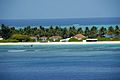
A beach resort on Kadmat Island.
-
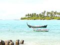
Boats docked at Kalpeni Island.
-
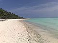
A view of Minicoy Island.
-
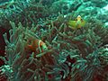
Anemone fish in the waters of Lakshadweep.
-
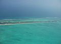
The airstrip on Agatti Island.
-
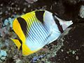
A Butterfly fish, the state animal of Lakshadweep.
-
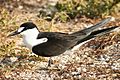
A Sooty tern, the state bird of Lakshadweep.
-
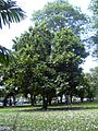
A Breadfruit tree, the state tree of Lakshadweep.
-
Neelakurinji flower, the state flower of Lakshadweep.
See also
 In Spanish: Laquedivas para niños
